METAR & TAF 56F
56F does not publish a METAR.
Showing the nearest reporting station: KSWW (AVENGER FLD) · 21.6 NM away. Conditions at 56F may differ.
METAR · KSWW
Observed 13:35Z
KSWW 271335Z AUTO 19011KT 10SM 27/20 A3003 RMK AO2 T02670197
- Wind
- 190° @ 11 kt
- Visibility
- 10 SM
- Temp / Dew
- 27°C / 20°C
- Altimeter
- 30.03 inHg
- Clouds
- Clear
- Density alt
- 3,710 ft
- Ceiling
- Unlimited
- Rules
- VFR
Airport info & contacts
Manager on record, flight service, ARTCC, attendance schedule and pattern altitude — published by the FAA and refreshed every 28 days.
Location
- From city
- 3 NM SE
- VFR sectional
- DALLAS-FT WORTH
- ARTCC
- ZFW · FORT WORTH
- NOTAM facility
- FTW (NOTAM-D)
Airport manager
- Name
- JUDGE KEN HOLT
- Phone
- 325-776-2151
- Address
- P.O. BOX 306, ROBY TX 79543
Flight service · Hours
- FSS FTW
- FORT WORTH1-800-WX-BRIEF
- Attendance
- Unattended
Frequencies
Tap any row to copy the frequency to your clipboard.
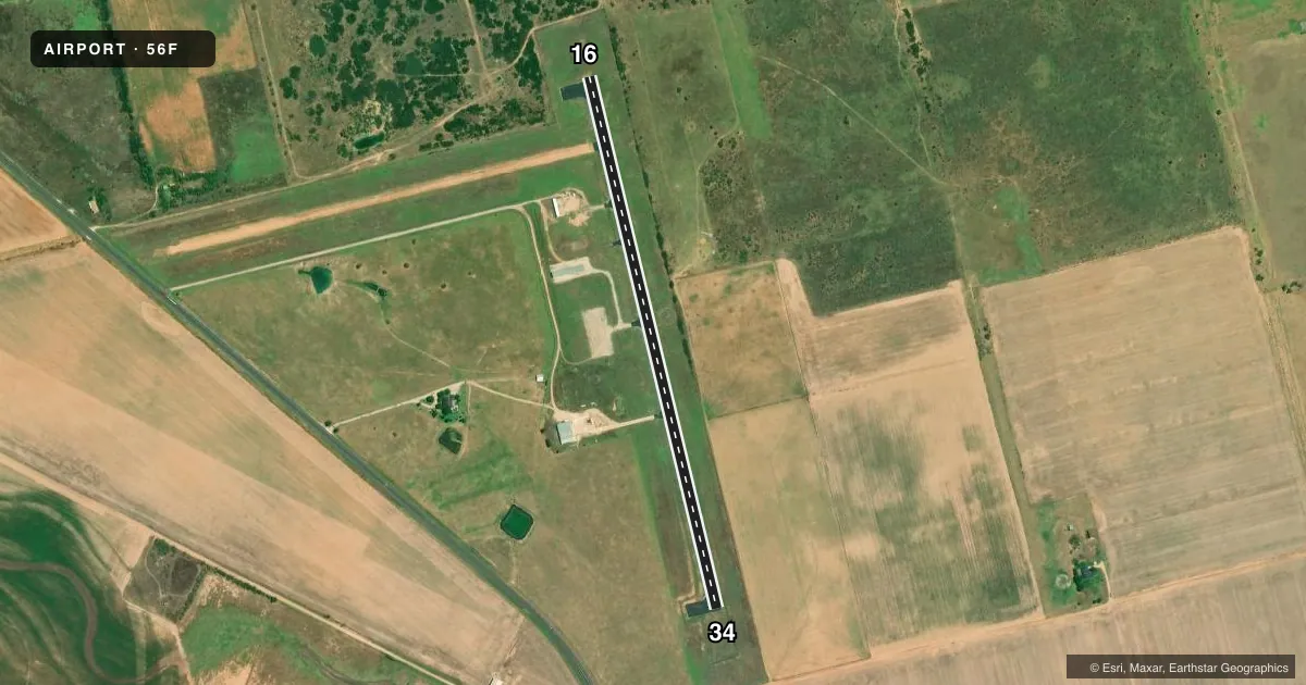
Runways & pattern
Full pagePattern entry · RWY 16
LEFT TRAFFICRunway end performance
| End | TORA | TODA | ASDA | LDA | VGSI | Approach lights | Obstruction |
|---|---|---|---|---|---|---|---|
| 16 | — | — | — | — | — | — | 20', trees, 440' from thr, 150' R of cntrln, slope 12 |
| 34 | — | — | — | — | — | — | 15', road, 500' from thr, 155' R of cntrln, slope 20 |
Declared distances in feet. TORA = takeoff run available, TODA = takeoff distance, ASDA = accelerate-stop, LDA = landing distance.
Airport sketch
Runways drawn to scale from FAA survey coordinates, rendered over satellite imagery. Not for navigation.
Approaches & charts
Services on the field
Fuel grades, oxygen, maintenance, ramp storage and lighting — as declared to the FAA by the airport operator.
Fuel & services
- Fuel
- Not available
- Oxygen (bottled)
- Not available
- Oxygen (bulk)
- Not available
- Airframe repair
- Not available
- Power plant repair
- Not available
- Other services
- AGRI
Ramp & ground
- Transient storage
- Tie-down
- Landing fee
- No fee published
- Customs
- Not available
- Lighting schedule
- SS-SR
- Beacon schedule
- SS-SR
- Beacon
- White / Green (civil land)(WG)
- Wind indicator
- Lighted
- Segmented circle
- Yes
Fuel & FBOs
Cheapest 100LL and Jet A on the field and nearby. Always confirm with the FBO before taxi.
Airport notes
Surface conditions, obstructions, local procedures, lighting outages and other notes published with each FAA cycle.
General notes
- AGRICULTURAL ACFT ACT INVOF ARPT.
- FOR CD CTC FORT WORTH ARTCC AT 817-858-7584.
VFR map & nearby airports
VFR sectional. Tap any ICAO chip to open that airport.
Key facts · 56F
Answer card- ICAO
- 56F
- Name
- FISHER COUNTY
- Location
- ROTAN/ROBY, TEXAS
- Elevation
- 1,941 ft MSL
- Traffic pattern altitude
- 2,941 ft MSL (1,000 AGL)
- Control tower
- Non-towered (use CTAF)
- Total runways
- 1
- Longest runway
- 16/34 · 3,300 ft
- Published ILS approaches
- 0
- Published frequencies
- 1
- Magnetic variation
- 8°
- Current flight rules
- VFR
- Current wind
- 190° at 11 kt
- Favored runway now
- RWY 16
Fisher County Airport sits near Rotan and Roby in west Texas. The field elevation is 1,941 ft MSL. It has one runway. Runway 16/34 is 3,300 ft of asphalt with magnetic headings 166° and 347°. There is no control tower. CTAF is 122.9.
No ILS approaches are published here. Pattern altitude is not published in the facts, so use the current FAA Chart Supplement before you go. The airport has no on-field FBOs listed, so plan on confirming services directly with the airport operator or by calling the field on CTAF before arrival. Published remarks note that clearance delivery is handled through Fort Worth ARTCC at 817-858-7584. Agricultural aircraft are active in the area, so expect low-level traffic near the airport. With the elevation close to 2,000 ft MSL, performance planning matters on warm days. Check density altitude before departure and keep an eye out for ag operations in the pattern and nearby airspace.