METAR & TAF KSWW
Current METAR
Observed 13:35Z
KSWW 271335Z AUTO 19011KT 10SM 27/20 A3003 RMK AO2 T02670197
- Wind
- 190° @ 11 kt
- Visibility
- 10 SM
- Temp / Dew
- 27°C / 20°C
- Altimeter
- 30.03 inHg
- Clouds
- Clear
- Density alt
- 4,254 ft
- Ceiling
- Unlimited
- Rules
- VFR
Airport info & contacts
Manager on record, flight service, ARTCC, attendance schedule and pattern altitude — published by the FAA and refreshed every 28 days.
Location
- From city
- 3 NM W
- VFR sectional
- DALLAS-FT WORTH
- ARTCC
- ZFW · FORT WORTH
- NOTAM facility
- SWW (NOTAM-D)
Airport manager
- Name
- LYNN BARRETT
- Phone
- 325-235-8478
- Address
- 317 HOMER K TAYLOR DR, P.O. BOX 450, SWEETWATER TX 79556
Flight service · Hours
- FSS FTW
- FORT WORTH1-800-WX-BRIEF
- Attendance
- M-TH · 0730-1730
- F · 0800-1200
Frequencies
Tap any row to copy the frequency to your clipboard.
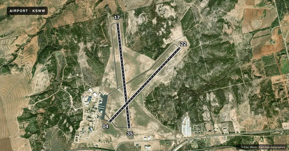
Runways & pattern
Full pagePattern entry · RWY 17
LEFT TRAFFIC| Runway | Heading (°M) | Length | Surface | Traffic |
|---|---|---|---|---|
| 17/35Favored | 166° / 346° | 5,840 ft | ASPH | Standard L |
| 04/22 | 35° / 215° | 5,658 ft | ASPH | Standard L |
Runway end performance
| End | TORA | TODA | ASDA | LDA | VGSI | Approach lights | Obstruction |
|---|---|---|---|---|---|---|---|
| 17 | — | — | — | — | PAPI 4-box left(3°) | — | 12', trees, 388' from thr, 270' R of cntrln, slope 15 |
| 35 | — | — | — | — | PAPI 4-box left(3°) | — | 37', pole, 820' from thr, 325' R of cntrln, slope 16 |
| 04 | — | — | — | — | PAPI 2-box left(3°) | — | 37', trees, 1060' from thr, 300' R of cntrln, slope 23 |
| 22 | — | — | — | — | PAPI 2-box left(3°) | — | 35', pole, 555' from thr, 245' R of cntrln, slope 10 |
Declared distances in feet. TORA = takeoff run available, TODA = takeoff distance, ASDA = accelerate-stop, LDA = landing distance.
Airport sketch
Runways drawn to scale from FAA survey coordinates, rendered over satellite imagery. Not for navigation.
Approaches & charts
Services on the field
Fuel grades, oxygen, maintenance, ramp storage and lighting — as declared to the FAA by the airport operator.
Fuel & services
- Fuel
- 100LLA1+
- Airframe repair
- Not available
- Power plant repair
- Not available
- Other services
- INSTR,RNTL
Ramp & ground
- Transient storage
- Tie-down
- Hangar
- Landing fee
- No fee published
- Customs
- Not available
- Lighting schedule
- SS-SR
- Beacon schedule
- SS-SR
- Beacon
- White / Green (civil land)(WG)
- Wind indicator
- Lighted
- Segmented circle
- Yes
Fuel & FBOs
Cheapest 100LL and Jet A on the field and nearby. Always confirm with the FBO before taxi.
Airport notes
Surface conditions, obstructions, local procedures, lighting outages and other notes published with each FAA cycle.
General notes
- FOR CD CTC FORT WORTH ARTCC AT 817-858-7584.
- RWY 04/22 & 17/35, ACFT NOT VSB FM OPPOSITE END OF RWY.
Fuel notes
- 100LLFUEL 24 HR SELF SERVE.
Approach & departure obstructions
- 2215 FT GRVL ROAD 199 FT DSTC, 236 FT L.
Other notes
- ARPT OPNSLENHOBBS122@GMAIL.COM
VFR map & nearby airports
VFR sectional. Tap any ICAO chip to open that airport.
Key facts · KSWW
Answer card- ICAO
- KSWW
- Name
- AVENGER FLD
- Location
- SWEETWATER, TEXAS
- Elevation
- 2,379.7 ft MSL
- Traffic pattern altitude
- 3,379.7 ft MSL (1,000 AGL)
- Control tower
- Non-towered (use CTAF)
- Total runways
- 2
- Longest runway
- 17/35 · 5,840 ft
- Published ILS approaches
- 0
- Published frequencies
- 4
- Magnetic variation
- 8°
- Current flight rules
- VFR
- Current wind
- 190° at 11 kt
- Favored runway now
- RWY 17
Avenger Fld sits in Sweetwater, Texas. Field elevation is 2,379.7 ft MSL. The airport has two asphalt runways. The longest is 17/35 at 5,840 ft. There is no control tower. CTAF and UNICOM are both 122.8. Approach and departure support is listed on 127.2 and 282.3 through Abilene. No ILS approaches are published, so plan with the current chart and your own weather minimums in mind.
Pattern altitude is not published. Use 1,000 ft AGL for light piston traffic unless the current Chart Supplement says otherwise. The field sits in west Texas, so density altitude can matter on warm days. That is worth planning for at this elevation. The published remarks also say aircraft on 04/22 and 17/35 are not visible from the opposite end of the runway. That makes good position reports more important than usual. There is also a 15-foot gravel road near runway 22, 199 feet out and 236 feet left of the centerline. Watch that side of the field on final.
Sweetwater Municipal Airport is on the field. It carries 100LL and Jet A. 100LL is available 24 hours self-serve. For clearance delivery, Fort Worth ARTCC is listed at 817-858-7584. Check the current FAA Chart Supplement before you go for any changes or local procedures.