METAR & TAF KABI
Current METAR
Observed 15:52Z
KABI 271552Z 19012KT 10SM CLR 32/21 A2999 RMK AO2 SLP125 T03170211 $
- Wind
- 190° @ 12 kt
- Visibility
- 10 SM
- Temp / Dew
- 32°C / 21°C
- Altimeter
- 29.99 inHg
- Clouds
- CLR
- Density alt
- 4,174 ft
- Ceiling
- Unlimited
- Rules
- VFR
Airport info & contacts
Manager on record, flight service, ARTCC, attendance schedule and pattern altitude — published by the FAA and refreshed every 28 days.
Location
- From city
- 3 NM SE
- VFR sectional
- DALLAS-FT WORTH
- ARTCC
- ZFW · FORT WORTH
- NOTAM facility
- ABI (NOTAM-D)
Airport manager
- Name
- DON GREEN
- Phone
- 325-676-6367
- Address
- 2933 AIRPORT BLVD SUITE 200, ABILENE TX 79602
Flight service · Hours
- FSS FTW
- FORT WORTH1-800-WX-BRIEF
- Attendance
- ALL
Frequencies
Tap any row to copy the frequency to your clipboard.
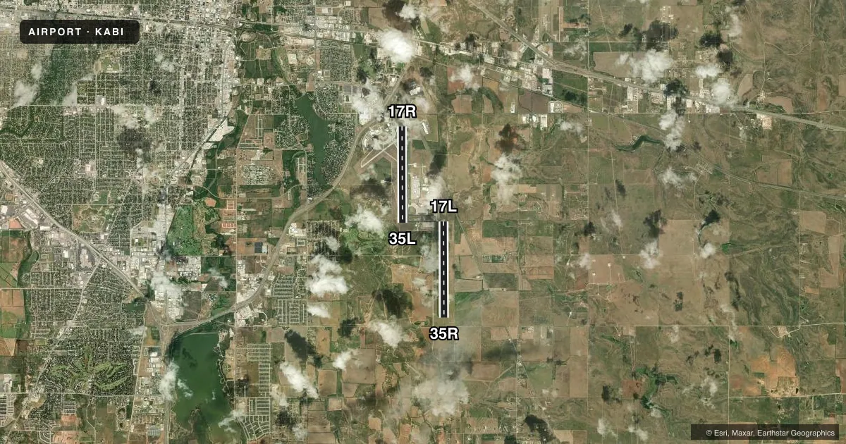
Runways & pattern
Full pagePattern entry · RWY 17R
RIGHT TRAFFIC| Runway | Heading (°M) | Length | Surface | Traffic |
|---|---|---|---|---|
| 17R/35LFavored | 175° / 355° | 7,208 ft | ASPH | 17R R |
| 17L/35R | 175° / 355° | 7,198 ft | ASPH | 35R R |
Runway end performance
| End | TORA | TODA | ASDA | LDA | VGSI | Approach lights | Obstruction |
|---|---|---|---|---|---|---|---|
| 17R | 7,202' | 7,202' | 7,202' | 7,202' | PAPI 4-box left(3°) | — | — |
| 35L | 7,202' | 7,202' | 7,202' | 7,202' | PAPI 4-box left(3°) | — | — |
| 17L | 7,198' | 7,198' | 7,198' | 7,198' | PAPI 4-box left(3°) | — | 2', gnd, 200' from thr, 0' R of cntrln, slope 0 |
| 35R | 7,198' | 7,198' | 7,198' | 7,198' | — | MALSR | — |
Declared distances in feet. TORA = takeoff run available, TODA = takeoff distance, ASDA = accelerate-stop, LDA = landing distance.
Airport sketch
Runways drawn to scale from FAA survey coordinates, rendered over satellite imagery. Not for navigation.
Approaches & charts
ILS · 2
Services on the field
Fuel grades, oxygen, maintenance, ramp storage and lighting — as declared to the FAA by the airport operator.
Fuel & services
- Fuel
- 100LLA
- Oxygen (bottled)
- Not available
- Oxygen (bulk)
- HIGH/LOW
- Airframe repair
- Major
- Power plant repair
- Major
- Other services
- AFRT,AVNCS,CHTR,INSTR,SALES
Ramp & ground
- Transient storage
- Tie-down
- Hangar
- Landing fee
- No fee published
- Customs
- Not available
- Lighting schedule
- SS-SR
- Beacon schedule
- SS-SR
- Beacon
- White / Green (civil land)(WG)
- Wind indicator
- Lighted
- Segmented circle
- Yes
Fuel & FBOs
Cheapest 100LL and Jet A on the field and nearby. Always confirm with the FBO before taxi.
Airport notes
Surface conditions, obstructions, local procedures, lighting outages and other notes published with each FAA cycle.
General notes
- UNCTLD ARPT 2 NM NE OF ARPT, PAT ALT 2300 FT.
- MIL AVN SVCS AVBL AT ARPT.
- HIGH BIRD ACTVTY ON AND INVOF ARPT.
Runway surface & condition
- 17L/35RPCR VALUE: 600/F/D/W/T
- 17R/35LPCR VALUE: 680/F/D/W/T
Other notes
- ABI IS ARFF INDEX B; ARFF INDEX C AVBL WITH PPR.
VFR map & nearby airports
VFR sectional. Tap any ICAO chip to open that airport.
Key facts · KABI
Answer card- ICAO
- KABI
- Name
- ABILENE RGNL
- Location
- ABILENE, TEXAS
- Elevation
- 1,790.6 ft MSL
- Traffic pattern altitude
- 2,790.6 ft MSL (1,000 AGL)
- Control tower
- Towered · 24
- Total runways
- 2
- Longest runway
- 17R/35L · 7,208 ft
- Published ILS approaches
- 2
- Published frequencies
- 16
- Magnetic variation
- 5°
- Current flight rules
- VFR
- Current wind
- 190° at 12 kt
- Favored runway now
- RWY 17R
Abilene Rgnl Airport sits in Abilene, Texas. Field elevation is 1,790.6 ft MSL. The airport has two asphalt runways. The longest is 7,208 ft. Tower service is available 24 hours. ILS approaches are published for runway ends 17R and 35R. Pattern altitude is not published. Use 1,000 ft AGL for light piston operations unless the current Chart Supplement says otherwise.
Freeman Jet Center - Abilene is on the field. It carries 100LL and Jet A. Call (325) 677-2601 for current service details before arrival. The airport also supports military aviation services. Published remarks note high bird activity on and near the airport. That matters here, especially during takeoff and landing.
The runways are 17L/35R at 7,198 ft and 17R/35L at 7,208 ft. Both are long enough for a wide range of general aviation traffic. The airport has ARFF Index B. Index C is available with prior permission required. There is also an uncontrolled airport 2 NM northeast with a pattern altitude of 2,300 ft. Watch the traffic picture carefully in the local area. If you need current noise, curfew, or airspace details, check the current FAA Chart Supplement before you go.