METAR & TAF F06
F06 does not publish a METAR.
Showing the nearest reporting station: KCDS (CHILDRESS MUNI) · 25.1 NM away. Conditions at F06 may differ.
METAR · KCDS
Observed 16:53Z
KCDS 271653Z AUTO 21011G14KT 10SM CLR 35/17 A2995 RMK AO2 SLP107 T03500172
- Wind
- 210° @ 11G14 kt
- Visibility
- 10 SM
- Temp / Dew
- 35°C / 17°C
- Altimeter
- 29.95 inHg
- Clouds
- CLR
- Density alt
- 4,854 ft
- Ceiling
- Unlimited
- Rules
- VFR
Airport info & contacts
Manager on record, flight service, ARTCC, attendance schedule and pattern altitude — published by the FAA and refreshed every 28 days.
Location
- From city
- 1 NM SE
- VFR sectional
- DALLAS-FT WORTH
- ARTCC
- ZFW · FORT WORTH
- NOTAM facility
- FTW (NOTAM-D)
Airport manager
- Name
- JON SESSIONS
- Phone
- 806-447-2544
- Address
- PO BOX 949, WELLINGTON TX 79095
Flight service · Hours
- FSS FTW
- FORT WORTH1-800-WX-BRIEF
- Attendance
- Unattended
Frequencies
Tap any row to copy the frequency to your clipboard.
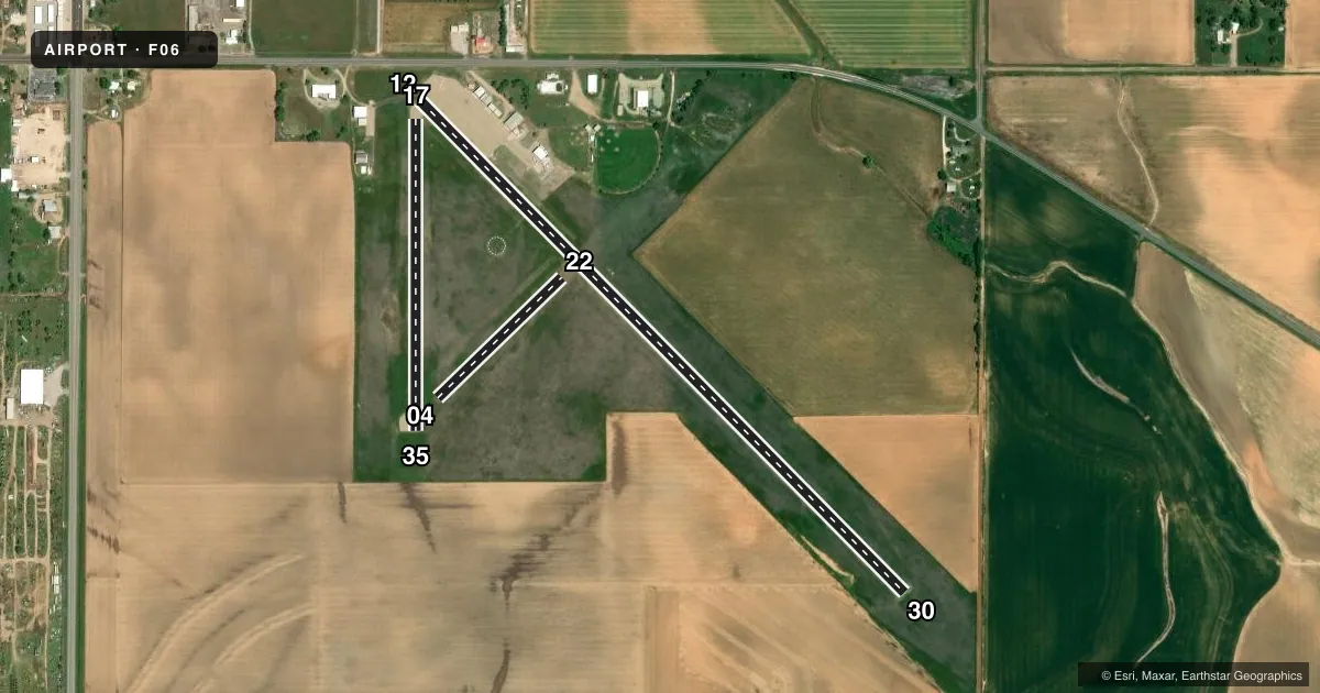
Runways & pattern
Full pagePattern entry · RWY 22
LEFT TRAFFIC| Runway | Heading (°M) | Length | Surface | Traffic |
|---|---|---|---|---|
| 12/30 | 127° / 307° | 4,035 ft | ASPH | Standard L |
| 17/35 | 172° / 352° | 1,819 ft | ASPH | Standard L |
| 04/22Favored | 38° / 218° | 1,010 ft | TURF | Standard L |
Runway end performance
| End | TORA | TODA | ASDA | LDA | VGSI | Approach lights | Obstruction |
|---|---|---|---|---|---|---|---|
| 12 | — | — | — | — | — | — | 18', road, 200' from thr, 87' R of cntrln, slope 0 |
| 30 | — | — | — | — | — | — | 10', road, 440' from thr, 145' R of cntrln, slope 24 |
| 17 | — | — | — | — | — | — | 20', road, 322' from thr, 0' R of cntrln, slope 6 |
| 22 | — | — | — | — | — | — | 60', pole, 686' from thr, 65' R of cntrln, slope 11 |
Declared distances in feet. TORA = takeoff run available, TODA = takeoff distance, ASDA = accelerate-stop, LDA = landing distance.
Airport sketch
Runways drawn to scale from FAA survey coordinates, rendered over satellite imagery. Not for navigation.
Approaches & charts
Services on the field
Fuel grades, oxygen, maintenance, ramp storage and lighting — as declared to the FAA by the airport operator.
Fuel & services
- Fuel
- 100LL
- Oxygen (bottled)
- Not available
- Oxygen (bulk)
- Not available
- Other services
- AGRI
Ramp & ground
- Transient storage
- Tie-down
- Landing fee
- No fee published
- Customs
- Not available
- Lighting schedule
- SEE RMK
- Wind indicator
- Lighted
- Segmented circle
- Yes
Fuel & FBOs
Cheapest 100LL and Jet A on the field and nearby. Always confirm with the FBO before taxi.
Airport notes
Surface conditions, obstructions, local procedures, lighting outages and other notes published with each FAA cycle.
General notes
- EXTENSIVE AG OPNS DURING SPRING/SUMMER.
- FOR CD CTC FORT WORTH ARTCC AT 817-858-7584.
Lighting notes
- MIRLS RY 12/30 PRESET TO LOW TO INCR INST AND ACTVT - CTAF.
Approach & departure obstructions
- 124 FT FENCE 150 FT DSTC 90 FT L.
- 12MARKINGS FADED, BARELY VSBL.
- 30MARKINGS FADED, BARELY VSBL.
- 04RWY 04/22 MKD WITH 3 FT BARREL HALVES PAINTED BLACK & WHITE.
- 12APCH SLOPE 32:1 TO DSPLCD THR OVR 18 FT RD 590 FT DSTC, 184 FT L
- 17APCH SLOPE 27:1 TO DSPLCD THR OVR 20 FT RD, 540 FT DSTC, 0B.
Other notes
- MANAGERCITY MANAGER.
VFR map & nearby airports
VFR sectional. Tap any ICAO chip to open that airport.
Key facts · F06
Answer card- ICAO
- F06
- Name
- MARIAN AIRPARK
- Location
- WELLINGTON, TEXAS
- Elevation
- 2,009 ft MSL
- Traffic pattern altitude
- 3,009 ft MSL (1,000 AGL)
- Control tower
- Non-towered (use CTAF)
- Total runways
- 3
- Longest runway
- 12/30 · 4,035 ft
- Published ILS approaches
- 0
- Published frequencies
- 1
- Magnetic variation
- 8°
- Current flight rules
- VFR
- Current wind
- 210° at 11 kt
- Favored runway now
- RWY 22
Marian Airpark is in Wellington, Texas. The field elevation is 2,009 ft MSL. It has three runways. The longest is runway 12/30 at 4,035 ft asphalt. Runway 17/35 is 1,819 ft asphalt. Runway 04/22 is 1,010 ft turf.
There is no control tower. CTAF is 122.9. No ILS approaches are published. Pattern altitude is not published, so use the standard 1,000 ft AGL for light piston operations unless the current FAA Chart Supplement says otherwise. The on-field FBO is Marian Airpark. It carries AVGAS 100LL. Call (806) 447-2544 before arrival if you need current fuel or ramp details.
The published remarks matter here. Runway 12 has faded markings. Runway 30 has faded markings too. Runway 04/22 uses black and white barrel halves for marking. Runway 12 has displaced-threshold obstacles nearby, including a fence and roads close to the approach path. The runway 12 lighting is medium intensity. It is preset low for instrument use and activates on CTAF. Spring and summer can bring extensive agricultural activity, so expect local traffic and field work near the airport. The field sits at 2,009 ft MSL, so density altitude can run high on warm days. Check the current FAA Chart Supplement for any operating notes before you go.