METAR & TAF KAEX
Current METAR
Observed 12:53Z
KAEX 271253Z 27006KT 8SM CLR 27/24 A3000 RMK AO2 SLP159 T02670244
- Wind
- 270° @ 6 kt
- Visibility
- 8 SM
- Temp / Dew
- 27°C / 24°C
- Altimeter
- 30.00 inHg
- Clouds
- CLR
- Density alt
- 1,450 ft
- Ceiling
- Unlimited
- Rules
- VFR
Airport info & contacts
Manager on record, flight service, ARTCC, attendance schedule and pattern altitude — published by the FAA and refreshed every 28 days.
Location
- From city
- 4 NM W
- VFR sectional
- HOUSTON
- Pattern altitude
- 1,200 ft AGL · 1,288 ft MSL
- ARTCC
- ZHU · HOUSTON
- NOTAM facility
- AEX (NOTAM-D)
Airport manager
- Name
- SCOTT GAMMEL
- Phone
- 318-427-6419
- Address
- 1611 ARNOLD DR, ALEXANDRIA LA 71303
Flight service · Hours
- FSS DRI
- DE RIDDER1-800-WX-BRIEF
- Attendance
- ALL
Frequencies
Tap any row to copy the frequency to your clipboard.
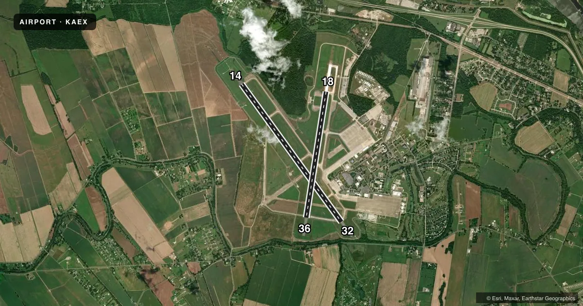
Runways & pattern
Full pagePattern entry · RWY 32
LEFT TRAFFIC| Runway | Heading (°M) | Length | Surface | Traffic |
|---|---|---|---|---|
| 14/32Favored | 141° / 321° | 9,352 ft | CONC | Standard L |
| 18/36 | 186° / 6° | 7,001 ft | ASPH-CONC | Standard L |
Runway end performance
| End | TORA | TODA | ASDA | LDA | VGSI | Approach lights | Obstruction |
|---|---|---|---|---|---|---|---|
| 14 | 9,352' | 9,352' | 9,352' | 9,352' | PAPI 4-box left(3°) | MALSR | — |
| 32 | 9,352' | 9,352' | 9,352' | 9,352' | PAPI 4-box left(3°) | — | — |
| 18 | 7,001' | 7,001' | 7,001' | 7,001' | PAPI 4-box left(3°) | — | — |
| 36 | 7,001' | 7,001' | 7,001' | 7,001' | PAPI 4-box left(3°) | — | 76', trees, 1798' from thr, 322' R of cntrln, slope 21 |
Declared distances in feet. TORA = takeoff run available, TODA = takeoff distance, ASDA = accelerate-stop, LDA = landing distance.
Airport sketch
Runways drawn to scale from FAA survey coordinates, rendered over satellite imagery. Not for navigation.
Approaches & charts
ILS · 1
Services on the field
Fuel grades, oxygen, maintenance, ramp storage and lighting — as declared to the FAA by the airport operator.
Fuel & services
- Fuel
- 100AMOGAS
- Oxygen (bottled)
- Low pressure
- Oxygen (bulk)
- Low pressure
- Airframe repair
- Major
- Power plant repair
- Major
- Other services
- CHTR,INSTR,RNTL,SALES
Ramp & ground
- Transient storage
- Tie-down
- Hangar
- Landing fee
- No fee published
- Customs
- Not available
- Lighting schedule
- SS-SR
- Beacon schedule
- SS-SR
- Beacon
- White / Green (civil land)(WG)
- Wind indicator
- Lighted
- Segmented circle
- Yes
Fuel & FBOs
Cheapest 100LL and Jet A on the field and nearby. Always confirm with the FBO before taxi.
Airport notes
Surface conditions, obstructions, local procedures, lighting outages and other notes published with each FAA cycle.
General notes
- LGT ACFT FREQ CROSS APCH ZONES TO RWY 14/32 BLW 2000 FT MSL.
- EXTV LGT ACFT TFC (CROPDUSTERS) BLW 900 FT TO CIV ARPT 3.5 NM WSW OF FIELD.
- EXTSV HEL TFC DURING MIL EXER.
- COML & LIFEGUARD ACFT ONLY ON COML TRML RAMP; ALL OTHER ACFT UTILIZE TWY A TO FBO.
Runway surface & condition
- 14/32PCR VALUE: 630/R/A/W/T
- 18/36PCR VALUE: 580/R/A/W/T
Other notes
- PRVDD VFR ONLY.
- RIGHT RETANGULAR 1200 FT AGL, LEFT OVERHEAD 1700 FT AGL.
- MULTICOM FREQ 130.00 AVBL.
- 18/36CENTER 75 FT OF FIRST 3000 FT OF RWY 18 CONC, REMAINDER IS ASPH.
VFR map & nearby airports
VFR sectional. Tap any ICAO chip to open that airport.
Key facts · KAEX
Answer card- ICAO
- KAEX
- Name
- ALEXANDRIA INTL
- Location
- ALEXANDRIA, LOUISIANA
- Elevation
- 88.1 ft MSL
- Traffic pattern altitude
- 1,288.1 ft MSL (1,200 AGL)
- Control tower
- Towered · 24
- Total runways
- 2
- Longest runway
- 14/32 · 9,352 ft
- Published ILS approaches
- 1
- Published frequencies
- 10
- Magnetic variation
- 3°
- Current flight rules
- VFR
- Current wind
- 270° at 6 kt
- Favored runway now
- RWY 32
Alexandria Intl is in Alexandria, Louisiana. The field elevation is 88.1 ft MSL. It has 2 runways. The longest is 9,352 ft on runway 14/32. The airport has a control tower that operates 24 hours. One ILS approach is published for runway 14.
Pattern altitude is 1,200 ft AGL. That is 1,288.1 ft MSL. Published remarks say the right rectangular pattern is used at 1,200 ft AGL. The left overhead pattern is at 1,700 ft AGL. This is a busy field with light aircraft traffic. Cropdusters and helicopter activity also show up during military exercises. Light aircraft also cross the runway 14/32 approach area below 2,000 ft MSL, so keep your scan tight.
Million Air Alexandria is on the field. It carries 100LL and Jet A. The airport remarks also say commercial and lifeguard aircraft use the commercial terminal ramp. All other aircraft use taxiway A to the FBO. The published remarks say the field is for VFR use only. If you are planning an arrival or departure here, check the current FAA Chart Supplement for any operational changes before you go. The airport sits in flat Louisiana terrain, so the main concerns are traffic flow, pattern discipline and staying alert for mixed aircraft activity.