METAR & TAF KBPT
Current METAR
Observed 06:53Z
KBPT 270653Z AUTO 22004KT 10SM SCT020 25/24 A2998 RMK AO2 SLP152 T02500244
- Wind
- 220° @ 4 kt
- Visibility
- 10 SM
- Temp / Dew
- 25°C / 24°C
- Altimeter
- 29.98 inHg
- Clouds
- SCT
- Density alt
- 1,144 ft
- Ceiling
- Unlimited
- Rules
- VFR
Airport info & contacts
Manager on record, flight service, ARTCC, attendance schedule and pattern altitude — published by the FAA and refreshed every 28 days.
Location
- From city
- 9 NM SE
- VFR sectional
- HOUSTON
- ARTCC
- ZHU · HOUSTON
- NOTAM facility
- BPT (NOTAM-D)
Airport manager
- Name
- ALEX RUPP
- Phone
- 409-719-4900
- Address
- 5000 JERRY WARE DR SUITE 100, BEAUMONT TX 77705
Flight service · Hours
- FSS CXO
- MONTGOMERY COUNTY1-800-WX-BRIEF
- Attendance
- ALL
Frequencies
Tap any row to copy the frequency to your clipboard.
Runways & pattern
Full pagePattern entry · RWY 16
LEFT TRAFFIC| Runway | Heading (°M) | Length | Surface | Traffic |
|---|---|---|---|---|
| 12/30 | 120° / 300° | 6,751 ft | CONC | Standard L |
| 16/34Favored | 165° / 345° | 5,071 ft | ASPH-CONC | Standard L |
Runway end performance
| End | TORA | TODA | ASDA | LDA | VGSI | Approach lights | Obstruction |
|---|---|---|---|---|---|---|---|
| 12 | 6,751' | 6,751' | 6,508' | 6,508' | — | MALSR | 46', tree, 1041' from thr, 618' R of cntrln, slope 18 |
| 30 | 6,751' | 6,751' | 6,751' | 6,751' | VASI 4-box left(3°) | — | 41', tree, 1024' from thr, 529' R of cntrln, slope 20 |
| 16 | 5,070' | 5,070' | 5,070' | 5,070' | PAPI 4-box right(3°) | — | — |
| 34 | 5,070' | 5,070' | 5,070' | 5,070' | VASI 4-box left(3°) | — | — |
Declared distances in feet. TORA = takeoff run available, TODA = takeoff distance, ASDA = accelerate-stop, LDA = landing distance.
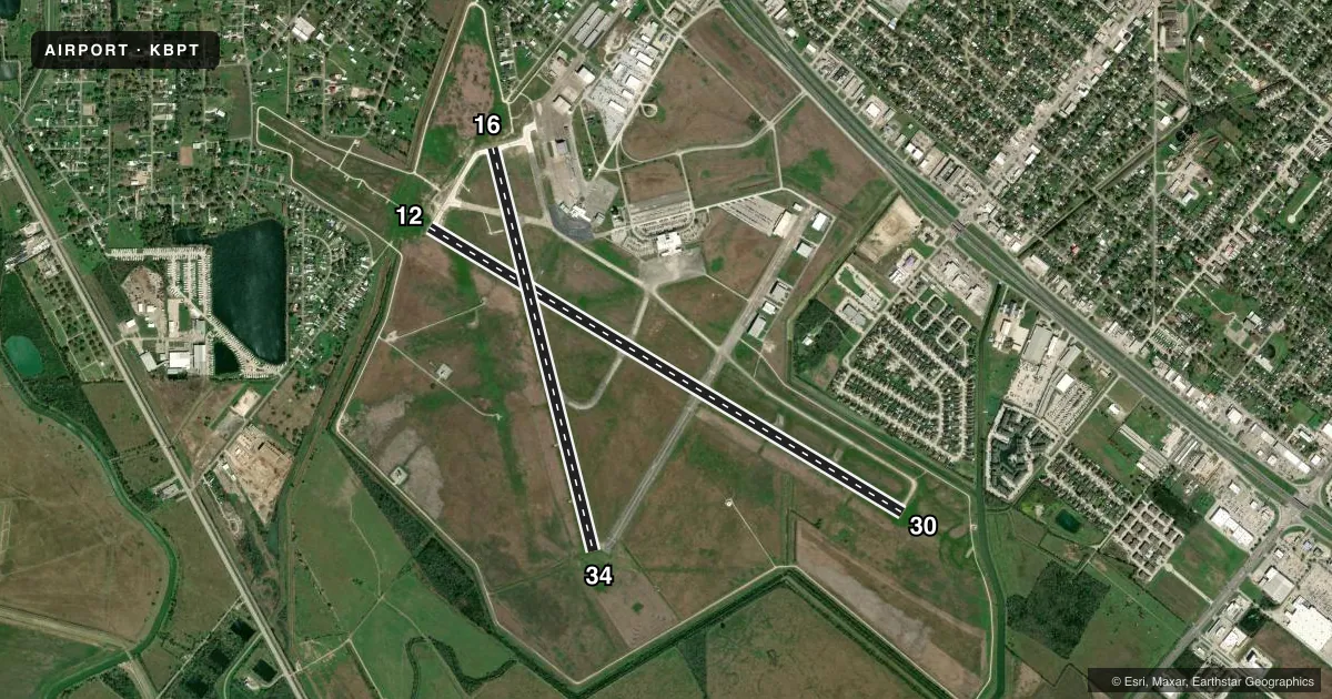
Airport sketch
Runways drawn to scale from FAA survey coordinates, rendered over satellite imagery. Not for navigation.
Approaches & charts
ILS · 1
Services on the field
Fuel grades, oxygen, maintenance, ramp storage and lighting — as declared to the FAA by the airport operator.
Fuel & services
- Fuel
- 100LLA
- Oxygen (bottled)
- Not available
- Oxygen (bulk)
- Low pressure
- Airframe repair
- Minor
- Power plant repair
- Minor
- Other services
- AFRT,CHTR,INSTR,RNTL
Ramp & ground
- Transient storage
- Tie-down
- Hangar
- Landing fee
- No fee published
- Customs
- Not available
- Lighting schedule
- SEE RMK
- Beacon schedule
- SS-SR
- Beacon
- White / Green (civil land)(WG)
- Wind indicator
- Lighted
- Segmented circle
- Yes
Fuel & FBOs
Cheapest 100LL and Jet A on the field and nearby. Always confirm with the FBO before taxi.
Airport notes
Surface conditions, obstructions, local procedures, lighting outages and other notes published with each FAA cycle.
General notes
- BIRD ACTVTY ON & INVOF ARPT.
- FOR CD WHEN ATCT IS CLSD CTC HOUSTON APCH AT 281-443-5844 TO CNL IFR AT 281-443-5888.
Lighting notes
- DUSK-DAWN. WHEN ATCT CLSD REIL RWYS 16, 30 & 34; HIRL RWY 12/30 & 16/34 PRESET MED INTST. ACTVT MALSR RWY 12 - CTAF.
Runway surface & condition
- 12/30PCR VALUE: 578/R/C/W/T
- 16/34PCR VALUE: 172/R/D/W/T
Other notes
- 16/34FIRST 1000 FT RWY 16 MUCH DARKER THAN REMAINDER OF RWY.
- 16/34FIRST 4271 FT OF RWY 34 GRVD.
VFR map & nearby airports
VFR sectional. Tap any ICAO chip to open that airport.
Key facts · KBPT
Answer card- ICAO
- KBPT
- Name
- JACK BROOKS RGNL
- Location
- BEAUMONT/PORT ARTHUR, TEXAS
- Elevation
- 14.8 ft MSL
- Traffic pattern altitude
- 1,014.8 ft MSL (1,000 AGL)
- Control tower
- Towered · 0600-2200
- Total runways
- 2
- Longest runway
- 12/30 · 6,751 ft
- Published ILS approaches
- 1
- Published frequencies
- 12
- Magnetic variation
- 1°
- Current flight rules
- VFR
- Current wind
- 220° at 4 kt
- Favored runway now
- RWY 16
Jack Brooks Rgnl sits in Beaumont/Port Arthur, Texas. Field elevation is 14.8 ft MSL. The airport has two runways. The longest is runway 12/30 at 6,751 ft. Runway 16/34 is 5,071 ft. The tower is open daily from 0600 to 2200.
Runway 12 has the published ILS approach. Pattern altitude is not published in the facts. Use the current Chart Supplement before you go. Jefferson County Fuel Service is on the field. It carries 100LL, Jet A and Jet A Prist. The field sits low and close to the Gulf Coast. Expect humid air and watch performance. Bird activity is reported on and near the airport. Keep a sharp scan on departure and arrival.
When the tower is closed, runway end identifier lights are available on runways 16, 30 and 34. The high intensity runway lights on both runways are preset to medium. The runway 12 approach lighting system can be activated on CTAF. Runway 16/34 has a grooved section on the first 4,271 ft of runway 34. The first 1,000 ft of runway 16 is darker than the rest of the pavement. If you are new to KBPT, brief the lighting setup and the runway layout before taxi.