METAR & TAF T78
Current METAR
Observed 20:35Z
KT78 242035Z AUTO 16008KT 9SM CLR 33/25 A3002 RMK AO2
- Wind
- 160° @ 8 kt
- Visibility
- 9 SM
- Temp / Dew
- 33°C / 25°C
- Altimeter
- 30.02 inHg
- Clouds
- CLR
- Density alt
- 2,122 ft
- Ceiling
- Unlimited
- Rules
- VFR
Airport info & contacts
Manager on record, flight service, ARTCC, attendance schedule and pattern altitude — published by the FAA and refreshed every 28 days.
Location
- From city
- 5 NM E
- VFR sectional
- HOUSTON
- ARTCC
- ZHU · HOUSTON
- NOTAM facility
- CXO (NOTAM-D)
Airport manager
- Name
- MARK BUSH
- Phone
- 936-352-1048
- Address
- 1829 SAM HOUSTON, LIBERTY TX 77575
Flight service · Hours
- FSS CXO
- MONTGOMERY COUNTY1-800-WX-BRIEF
- Attendance
- MON-FRI · 0800-1600
Frequencies
Tap any row to copy the frequency to your clipboard.
Runways & pattern
Full pagePattern entry · RWY 16
LEFT TRAFFICRunway end performance
| End | TORA | TODA | ASDA | LDA | VGSI | Approach lights | Obstruction |
|---|---|---|---|---|---|---|---|
| 16 | — | — | — | — | PAPI 2-box left(3°) | — | 40', trees, 220' from thr, 248' R of cntrln, slope 0 |
| 34 | — | — | — | — | — | — | 65', trees, 1250' from thr, 150' R of cntrln, slope 16 |
Declared distances in feet. TORA = takeoff run available, TODA = takeoff distance, ASDA = accelerate-stop, LDA = landing distance.
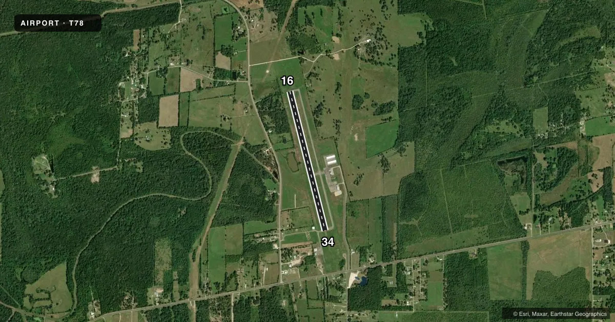
Airport sketch
Runways drawn to scale from FAA survey coordinates, rendered over satellite imagery. Not for navigation.
Approaches & charts
Services on the field
Fuel grades, oxygen, maintenance, ramp storage and lighting — as declared to the FAA by the airport operator.
Fuel & services
- Fuel
- 100LLA
- Oxygen (bottled)
- Not available
- Oxygen (bulk)
- Not available
- Airframe repair
- Major
- Power plant repair
- Major
- Other services
- AMB
Ramp & ground
- Transient storage
- Tie-down
- Landing fee
- No fee published
- Customs
- Not available
- Lighting schedule
- SEE RMK
- Beacon schedule
- SS-SR
- Beacon
- White / Green (civil land)(WG)
- Wind indicator
- Lighted
- Segmented circle
- Yes
Fuel & FBOs
Cheapest 100LL and Jet A on the field and nearby. Always confirm with the FBO before taxi.
Airport notes
Surface conditions, obstructions, local procedures, lighting outages and other notes published with each FAA cycle.
General notes
- FOR CD CTC HOUSTON APCH AT 281-443-5844 TO CNL IFR CALL 281-443-5888.
Lighting notes
- ACTVT MIRL RWY 16/34 - CTAF.
Fuel notes
- 100LL24 HR SELF-SVC FUEL.
Approach & departure obstructions
- 1610 FT FENCE, 0-199 FT DSTC, 245 FT R.
- 16OBSTN EXCEEDS 45 DEG ANGLE.
Other notes
- THIS AIRPORT HAS BEEN SURVEYED BY THE NATIONAL GEODETIC SURVEY.
VFR map & nearby airports
VFR sectional. Tap any ICAO chip to open that airport.
Key facts · T78
Answer card- ICAO
- T78
- Name
- LIBERTY MUNI
- Location
- LIBERTY, TEXAS
- Elevation
- 69.5 ft MSL
- Traffic pattern altitude
- 1,069.5 ft MSL (1,000 AGL)
- Control tower
- Non-towered (use CTAF)
- Total runways
- 1
- Longest runway
- 16/34 · 3,801 ft
- Published ILS approaches
- 0
- Published frequencies
- 3
- Magnetic variation
- 5°
- Current flight rules
- VFR
- Current wind
- 160° at 8 kt
- Favored runway now
- RWY 16
Liberty Muni sits in Liberty, Texas. Field elevation is 69.5 ft MSL. The airport has one runway. Runway 16/34 is 3,801 ft long and paved with asphalt. There is no control tower. CTAF is 122.9. The published pattern altitude is not listed, so use the standard 1,000 ft AGL for light piston operations unless the current Chart Supplement says otherwise.
No ILS approaches are published here. If you are planning an IFR arrival, work from the current approach chart package and coordinate with Houston Approach. Published remarks note medium intensity runway lights on 16/34 that activate on CTAF. They also note an obstruction issue near runway 16. Trees sit off the right side near the departure end, so give runway 16 a careful look before you commit. The field has been surveyed by the National Geodetic Survey.
Liberty Municipal Airport is on the field and carries AVGAS 100LL and Jet A Prist. It also has 24-hour self-serve 100LL fuel. For clearance delivery, Houston Approach uses 281-443-5844. For IFR cancellation, use 281-443-5888. If you are new to the airport, expect an uncontrolled field with Houston Approach frequencies in use and plan your arrival with the runway 16 obstruction note in mind.