METAR & TAF T41
Current METAR
Observed 07:35Z
KT41 270735Z AUTO 00000KT 10SM CLR 26/24 A2999 RMK AO2
- Wind
- 000° @ 0 kt
- Visibility
- 10 SM
- Temp / Dew
- 26°C / 24°C
- Altimeter
- 29.99 inHg
- Clouds
- CLR
- Density alt
- 1,264 ft
- Ceiling
- Unlimited
- Rules
- VFR
Airport info & contacts
Manager on record, flight service, ARTCC, attendance schedule and pattern altitude — published by the FAA and refreshed every 28 days.
Location
- From city
- 3 NM NW
- VFR sectional
- HOUSTON
- ARTCC
- ZHU · HOUSTON
- NOTAM facility
- CXO (NOTAM-D)
Airport manager
- Name
- RAY MAYO
- Phone
- 281-471-9650
- Address
- 2963 N 23RD STREET, LA PORTE TX 77571
Flight service · Hours
- FSS CXO
- MONTGOMERY COUNTY1-800-WX-BRIEF
- Attendance
- DALGT
Frequencies
Tap any row to copy the frequency to your clipboard.
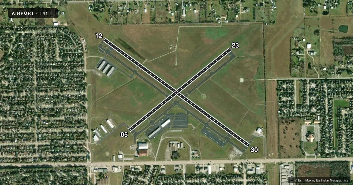
Runways & pattern
Full pagePattern entry · RWY 12
LEFT TRAFFIC| Runway | Heading (°M) | Length | Surface | Traffic |
|---|---|---|---|---|
| 12/30 | 121° / 301° | 4,165 ft | ASPH | Standard L |
| 05/23 | 46° / 226° | 2,998 ft | ASPH | Standard L |
Runway end performance
| End | TORA | TODA | ASDA | LDA | VGSI | Approach lights | Obstruction |
|---|---|---|---|---|---|---|---|
| 12 | — | — | — | — | PAPI 4-box left(3°) | — | 50', trees, 1115' from thr, 80' R of cntrln, slope 18 |
| 30 | — | — | — | — | — | — | 6', fence, 201' from thr, 236' R of cntrln, slope 0 |
| 05 | — | — | — | — | — | — | 44', pole, 915' from thr, 215' R of cntrln, slope 16 |
Declared distances in feet. TORA = takeoff run available, TODA = takeoff distance, ASDA = accelerate-stop, LDA = landing distance.
Airport sketch
Runways drawn to scale from FAA survey coordinates, rendered over satellite imagery. Not for navigation.
Approaches & charts
Services on the field
Fuel grades, oxygen, maintenance, ramp storage and lighting — as declared to the FAA by the airport operator.
Fuel & services
- Fuel
- 100LLA
- Airframe repair
- Major
- Power plant repair
- Major
- Other services
- AVNCS,INSTR,RNTL,SALES
Ramp & ground
- Transient storage
- Tie-down
- Landing fee
- No fee published
- Customs
- Not available
- Lighting schedule
- SEE RMK
- Beacon schedule
- SS-SR
- Beacon
- White / Green (civil land)(WG)
- Wind indicator
- Lighted
- Segmented circle
- Yes
Fuel & FBOs
Cheapest 100LL and Jet A on the field and nearby. Always confirm with the FBO before taxi.
Airport notes
Surface conditions, obstructions, local procedures, lighting outages and other notes published with each FAA cycle.
General notes
- FOR CD CTC HOUSTON APCH AT 281-443-5844. TO CNL IFR CTC HOUSTON APCH AT 281-443-5888.
Lighting notes
- ACTVT REIL RWY 12; PAPI RWY 12; MIRL RWYS 05/23 & 12/30 - CTAF.
Fuel notes
- 100LLFUEL 24 HR SELF SERVE.
Approach & departure obstructions
- 306 FT FENCE 199 FT DSTC 246 FT LEFT OF CNTRLN.
- 12PAPI RWY 12 UNUSBL BYD 8 DEG L OF RWY CNTRLN.
- 12OBSTN CLNC SLOPE 26:1 TO DSPLCD THLD OVR 30 FT POLES, 927 FT DSTC.
- 30OBSTN CLNC SLOPE 30:1 TO DSPLCD THLD.
Other notes
- THIS AIRPORT HAS BEEN SURVEYED BY THE NATIONAL GEODETIC SURVEY.
- PRE DATES THE ACT.
- MANAGERDIRECTOR OF PUBLIC WORKS.
VFR map & nearby airports
VFR sectional. Tap any ICAO chip to open that airport.
Key facts · T41
Answer card- ICAO
- T41
- Name
- LA PORTE MUNI
- Location
- LA PORTE, TEXAS
- Elevation
- 25.1 ft MSL
- Traffic pattern altitude
- 1,025.1 ft MSL (1,000 AGL)
- Control tower
- Non-towered (use CTAF)
- Total runways
- 2
- Longest runway
- 12/30 · 4,165 ft
- Published ILS approaches
- 0
- Published frequencies
- 5
- Magnetic variation
- 5°
- Current flight rules
- VFR
- Current wind
- 000° at 0 kt
- Favored runway now
- –
La Porte Muni sits in La Porte, Texas. Field elevation is 25.1 ft MSL. The airport has two asphalt runways. The longest is runway 12/30 at 4,165 ft. There is no control tower. Traffic uses CTAF 122.7. Pattern altitude is not published, so use the standard 1,000 ft AGL for light piston operations unless the current Chart Supplement says otherwise.
No ILS approaches are published here. Houston Approach handles IFR clearance delivery and IFR cancellation by phone. The field is low and coastal. Expect busy southeast Texas weather. Pay close attention to wind and visibility changes. Runway 12 has a PAPI. The published remarks say the PAPI is unusable beyond 8 degrees left of centerline. Runway 12 also has REILs. Both runways have medium intensity runway lights. There is a 6 ft fence near runway 30. The published obstacle notes also call out a slope issue on runway 12. That makes stabilized approaches important.
Tri-Star Aviation is on the field. It carries 100LL and Jet A with Prist. Harvey & Rihn Aviation is also on the field. It carries 100LL. 100LL is also available 24 hours self-serve. For a first-time arrival, the main things to brief are the non-towered pattern, the published lighting and PAPI notes and the lack of ILS support. Check the current FAA Chart Supplement for any noise or local operating notes before you go.