METAR & TAF T79
T79 does not publish a METAR.
Showing the nearest reporting station: KLVJ (PEARLAND RGNL) · 4.9 NM away. Conditions at T79 may differ.
METAR · KLVJ
Observed 14:53Z
KLVJ 261453Z AUTO VRB03KT 10SM CLR 30/24 A3008 RMK AO2 SLP183 T03000239 50006
- Wind
- VAR @ 3 kt
- Visibility
- 10 SM
- Temp / Dew
- 30°C / 24°C
- Altimeter
- 30.08 inHg
- Clouds
- CLR
- Density alt
- 1,670 ft
- Ceiling
- Unlimited
- Rules
- VFR
Airport info & contacts
Manager on record, flight service, ARTCC, attendance schedule and pattern altitude — published by the FAA and refreshed every 28 days.
Location
- From city
- 3 NM W
- VFR sectional
- HOUSTON
- ARTCC
- ZHU · HOUSTON
- NOTAM facility
- CXO (NOTAM-D)
Airport manager
- Name
- BERT WITHERS
- Phone
- 281-723-8403
- Address
- 2825 PIPER ROAD, PEARLAND TX 77584
Flight service · Hours
- FSS CXO
- MONTGOMERY COUNTY1-800-WX-BRIEF
- Attendance
- IREG
Frequencies
Tap any row to copy the frequency to your clipboard.
Runways & pattern
Full pagePattern entry · RWY 35
LEFT TRAFFICRunway end performance
| End | TORA | TODA | ASDA | LDA | VGSI | Approach lights | Obstruction |
|---|---|---|---|---|---|---|---|
| 17 | — | — | — | — | — | — | 16', road, 0' from thr, 54' R of cntrln, slope 0 |
| 35 | — | — | — | — | — | — | 50', trees, 0' from thr, 35' R of cntrln, slope 0 |
Declared distances in feet. TORA = takeoff run available, TODA = takeoff distance, ASDA = accelerate-stop, LDA = landing distance.
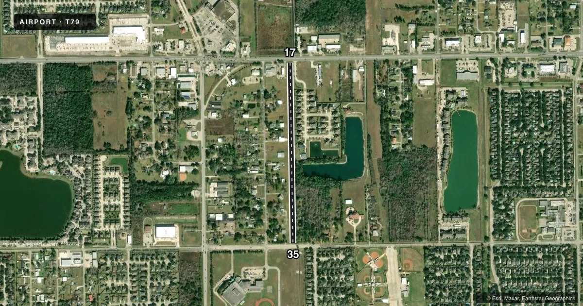
Airport sketch
Runways drawn to scale from FAA survey coordinates, rendered over satellite imagery. Not for navigation.
Approaches & charts
Services on the field
Fuel grades, oxygen, maintenance, ramp storage and lighting — as declared to the FAA by the airport operator.
Fuel & services
- Fuel
- Not available
Ramp & ground
- Transient storage
- Not published
- Landing fee
- No fee published
- Wind indicator
- Yes
- Segmented circle
- No
Fuel & FBOs
Cheapest 100LL and Jet A on the field and nearby. Always confirm with the FBO before taxi.
Airport notes
Surface conditions, obstructions, local procedures, lighting outages and other notes published with each FAA cycle.
General notes
- NMRS OBJECTS IN PRIM SFC ENTR RWY LEN - BLDGS, FENCES, TREES & BRUSH.
- NO TGLS.
- FOR CD CTC HOUSTON APCH AT 281-443-5844 TO CNL IFR CALL 281-443-5888.
Approach & departure obstructions
- 17CONTROLLING OBSTRUCTION EXCEEDS A 45 DEGREE SLOPE
- 17ALSO 45 FT POLE, 100 FT DSTC.
- 35ALSO 16 FT RD, 20 FT DSTC, 135 FT L/R.
Other notes
- PRVDD THRS DSPLD & MKD TO PRVD MIN 20:1 CLNC OVR PLINES & ANY/ALL OTR OBSTNS FINAL APCH; PLINES ADJT RWY ENDS OBSTN MKD IAW CHAPTER 3 AC 70/7460-2E. OWNER ENSURES PRESENCE OF OBSTNS IN RWY APCH AREAS ARE ADVERTISED TO ALERT TSNT PILOTS.
- MANAGERRESIDENTIAL AIRPARK - AMGR LIVES AT ARPT.
- 17/35SOFT WHEN WET.
VFR map & nearby airports
VFR sectional. Tap any ICAO chip to open that airport.
Key facts · T79
Answer card- ICAO
- T79
- Name
- SKYWAY MANOR
- Location
- PEARLAND, TEXAS
- Elevation
- 55 ft MSL
- Traffic pattern altitude
- 1,055 ft MSL (1,000 AGL)
- Control tower
- Non-towered (use CTAF)
- Total runways
- 1
- Longest runway
- 17/35 · 2,525 ft
- Published ILS approaches
- 0
- Published frequencies
- 1
- Magnetic variation
- 6°
- Current flight rules
- VFR
- Current wind
- 000° at 3 kt
- Favored runway now
- RWY 35
Skyway Manor (T79) is in Pearland, Texas. Field elevation is 55 ft MSL. It has one runway, 17/35, which is 2,525 ft long and surfaced in turf. The airport is non-towered. CTAF is 122.9. No ILS approaches are published here.
The pattern altitude is not published. Use the standard 1,000 ft AGL pattern unless the current Chart Supplement says otherwise. That works out to about 1,055 ft MSL at this field. The airport sits in a residential airpark. The manager lives on the field. That matters for arrivals and ground ops.
The published remarks are worth a close look before you go. There are displaced thresholds. The approach areas have power lines and other obstacles. The runway environment also includes buildings, fences, trees and brush in the primary surface. Runway 17/35 is soft when wet. No touch-and-go landings are allowed. If you need IFR coordination, Houston Approach handles clearance delivery. This is the kind of strip where a careful stabilized approach and a good obstacle scan matter more than usual.