METAR & TAF 6R5
6R5 does not publish a METAR.
Showing the nearest reporting station: KLVJ (PEARLAND RGNL) · 6.8 NM away. Conditions at 6R5 may differ.
METAR · KLVJ
Observed 00:53Z
KLVJ 250053Z AUTO 17006KT 8SM CLR 30/23 A3000 RMK AO2 SLP159 T03000233
- Wind
- 170° @ 6 kt
- Visibility
- 8 SM
- Temp / Dew
- 30°C / 23°C
- Altimeter
- 30.00 inHg
- Clouds
- CLR
- Density alt
- 1,754 ft
- Ceiling
- Unlimited
- Rules
- VFR
Airport info & contacts
Manager on record, flight service, ARTCC, attendance schedule and pattern altitude — published by the FAA and refreshed every 28 days.
Location
- From city
- 3 NM W
- VFR sectional
- HOUSTON
- ARTCC
- ZHU · HOUSTON
- NOTAM facility
- CXO (NOTAM-D)
Airport manager
- Name
- RANDY SMART
- Phone
- 713-208-8707
- Address
- 2102 CHERRY HILL DR, LEAGUE CITY TX 77573
Flight service · Hours
- FSS CXO
- MONTGOMERY COUNTY1-800-WX-BRIEF
- Attendance
- Unattended
Frequencies
Tap any row to copy the frequency to your clipboard.
Runways & pattern
Full pagePattern entry · RWY 12
LEFT TRAFFIC| Runway | Heading (°M) | Length | Surface | Traffic |
|---|---|---|---|---|
| 06/24 | 65° / 245° | 1,500 ft | TURF | Standard L |
| 03/21 | 35° / 215° | 1,420 ft | TURF | Standard L |
| 12/30Favored | 125° / 305° | 830 ft | TURF | Standard L |
Runway end performance
| End | TORA | TODA | ASDA | LDA | VGSI | Approach lights | Obstruction |
|---|---|---|---|---|---|---|---|
| 06 | — | — | — | — | — | — | 34', pline, 0' from thr, 55' R of cntrln, slope 0 |
| 24 | — | — | — | — | — | — | 50', trees, 0' from thr, 0' R of cntrln, slope 0 |
| 03 | — | — | — | — | — | — | 40', trees, 0' from thr, 45' R of cntrln, slope 0 |
| 21 | — | — | — | — | — | — | 40', trees, 0' from thr, 50' R of cntrln, slope 0 |
| 12 | — | — | — | — | — | — | 34', pline, 0' from thr, 0' R of cntrln, slope 0 |
| 30 | — | — | — | — | — | — | 50', trees, 0' from thr, 60' R of cntrln, slope 0 |
Declared distances in feet. TORA = takeoff run available, TODA = takeoff distance, ASDA = accelerate-stop, LDA = landing distance.
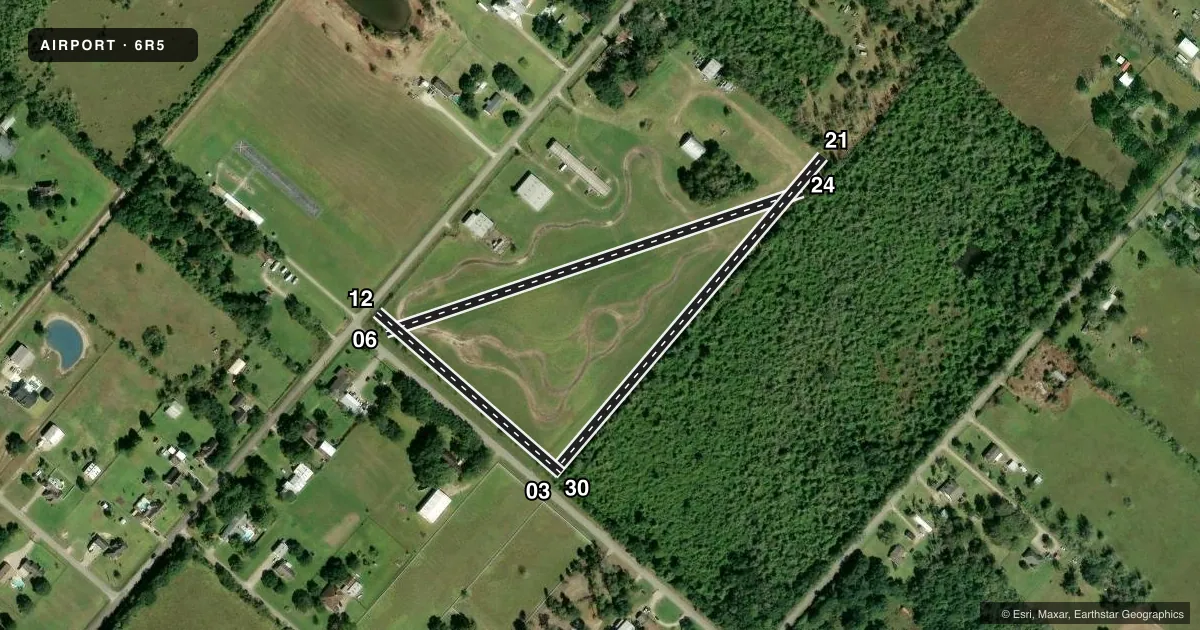
Airport sketch
Runways drawn to scale from FAA survey coordinates, rendered over satellite imagery. Not for navigation.
Approaches & charts
Services on the field
Fuel grades, oxygen, maintenance, ramp storage and lighting — as declared to the FAA by the airport operator.
Fuel & services
- Fuel
- Not available
Ramp & ground
- Transient storage
- Tie-down
- Hangar
- Landing fee
- No fee published
- Wind indicator
- Yes
- Segmented circle
- No
Fuel & FBOs
Cheapest 100LL and Jet A on the field and nearby. Always confirm with the FBO before taxi.
Airport notes
Surface conditions, obstructions, local procedures, lighting outages and other notes published with each FAA cycle.
General notes
- RWY 03, 6 FT FENCE 40 FT SE OF CNTRLN ALG SE EDGE. 50 FT TREES ALG RWY 03 RIGHT OF CNTRLN.
- RWY 21, 6 FT FENCE 20 FT DSTC, ACRS THE APCH. 30 FT TREES ALG RWY 21 LEFT OF CNTRLN.
- RADIO CONTROL MODEL ACFT OPRG AREA ADJ TO ARPT, NW.
- 6 FT ARPT SCTY FENCE. ALL GATES LOCKED. FOR INGRESS OR EGRESS, CTC AMGR.
- FOR CD CTC HOUSTON APCH AT 281-443-5844 TO CNL IFR CALL 281-443-5888.
Approach & departure obstructions
- 03CTLG OBSTN EXCEEDS 45 DEG SLP.
- 06CTLG OBSTN EXCEEDS 45 DEG SLP.
- 12CTLG OBSTN EXCEEDS 45 DEG SLP.
Other notes
- 03/21RWY DEFINED BY MOWING. DFCLT TO DTRM RWY DIMENSIONS. RWY SFC ROUGH & UNEVEN.
- 06/24RWY DEFINED BY MOWING. DFCLT TO DTRM RWY DIMENSIONS. RWY SFC ROUGH & UNEVEN.
- 12/30RWY DEFINED BY MOWING. DFCLT TO DTRM RWY DIMENSIONS. RWY SFC ROUGH & UNEVEN.
VFR map & nearby airports
VFR sectional. Tap any ICAO chip to open that airport.
Key facts · 6R5
Answer card- ICAO
- 6R5
- Name
- ALVIN AIRPARK
- Location
- ALVIN, TEXAS
- Elevation
- 43 ft MSL
- Traffic pattern altitude
- 1,043 ft MSL (1,000 AGL)
- Control tower
- Non-towered (use CTAF)
- Total runways
- 3
- Longest runway
- 06/24 · 1,500 ft
- Published ILS approaches
- 0
- Published frequencies
- 1
- Magnetic variation
- 6°
- Current flight rules
- VFR
- Current wind
- 170° at 6 kt
- Favored runway now
- RWY 12
Alvin Airpark sits in Alvin, Texas. The field elevation is 43 ft MSL. It has three turf runways. The longest is 1,500 ft on runway 06/24. This is an untowered field. CTAF is 122.9.
No ILS approaches are published here. Pattern altitude is not published, so use the standard 1,000 ft AGL for light piston operations unless the current FAA Chart Supplement says otherwise. The airport sits in a low coastal area near Houston. That means you should pay close attention to runway condition and obstacle clearance.
The published remarks matter here. Runway 06/24 is marked by mowing. Its dimensions are hard to judge from the air. The surface is rough and uneven. Runway 03 has a fence near the southeast side and trees along the right side. Runway 21 has a fence close to the threshold and trees along the left side. Runway 12 also has a listed obstruction near the departure path. There is also a radio control model aircraft area northwest of the airport. For IFR clearance delivery, Houston Approach is listed in the Chart Supplement. Gates are locked, so contact the airport manager for ingress or egress. No on-field FBOs are listed, so verify current fuel and service options before you go.