METAR & TAF KAXH
Current METAR
Observed 07:35Z
KAXH 270735Z AUTO 00000KT 24/23 A2999 RMK AO2 T02430227 PWINO
- Wind
- 000° @ 0 kt
- Visibility
- —
- Temp / Dew
- 24°C / 23°C
- Altimeter
- 29.99 inHg
- Clouds
- Clear
- Density alt
- 1,079 ft
- Ceiling
- Unlimited
- Rules
- VFR
Airport info & contacts
Manager on record, flight service, ARTCC, attendance schedule and pattern altitude — published by the FAA and refreshed every 28 days.
Location
- From city
- 15 NM SW
- VFR sectional
- HOUSTON
- ARTCC
- ZHU · HOUSTON
- NOTAM facility
- CXO (NOTAM-D)
Airport manager
- Name
- LEN FRANKLIN
- Phone
- 281-431-2581
- Address
- 503 MC KEEVER RD #1505, ARCOLA TX 77583
Flight service · Hours
- FSS CXO
- MONTGOMERY COUNTY1-800-WX-BRIEF
- Attendance
- ALL
Frequencies
Tap any row to copy the frequency to your clipboard.
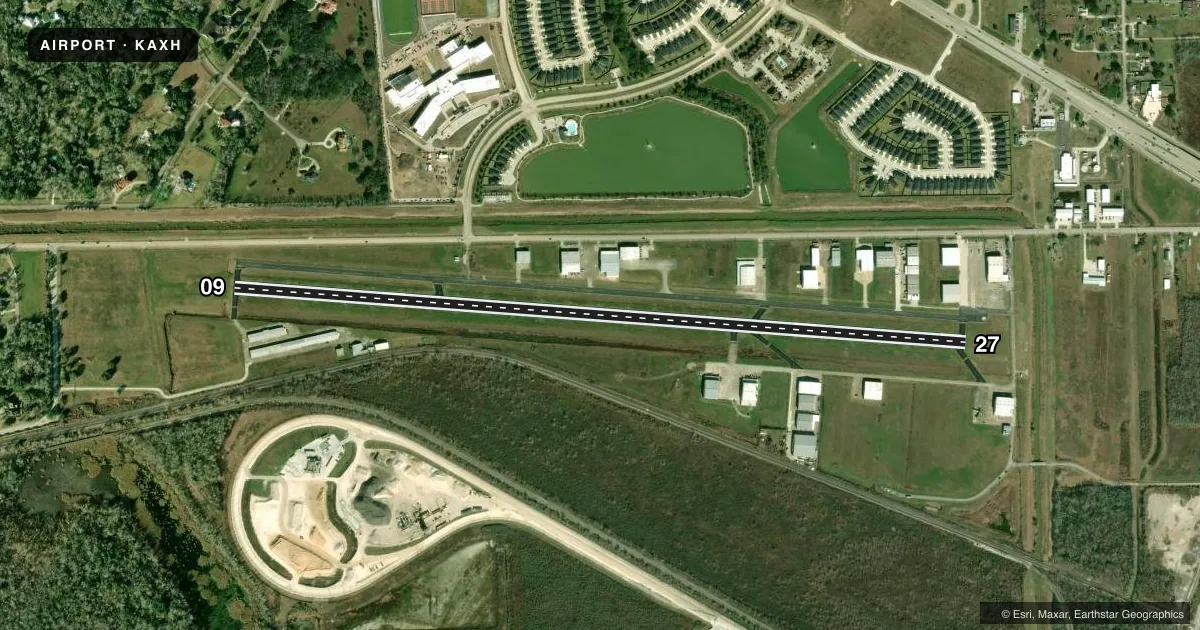
Runways & pattern
Full pagePattern entry · RWY 09
LEFT TRAFFICRunway end performance
| End | TORA | TODA | ASDA | LDA | VGSI | Approach lights | Obstruction |
|---|---|---|---|---|---|---|---|
| 09 | — | — | — | — | PAPI 2-box left(3.5°) | — | 15', road, 265' from thr, 260' R of cntrln, slope 4 |
| 27 | — | — | — | — | PAPI 2-box left(3°) | — | 15', road, 330' from thr, 0' R of cntrln, slope 8 |
Declared distances in feet. TORA = takeoff run available, TODA = takeoff distance, ASDA = accelerate-stop, LDA = landing distance.
Airport sketch
Runways drawn to scale from FAA survey coordinates, rendered over satellite imagery. Not for navigation.
Approaches & charts
ILS · 1
Services on the field
Fuel grades, oxygen, maintenance, ramp storage and lighting — as declared to the FAA by the airport operator.
Fuel & services
- Fuel
- 100LLA+
- Oxygen (bottled)
- High pressure
- Airframe repair
- Major
- Power plant repair
- Major
- Other services
- INSTR,RNTL
Ramp & ground
- Transient storage
- Tie-down
- Hangar
- Landing fee
- No fee published
- Customs
- Not available
- Lighting schedule
- SEE RMK
- Beacon schedule
- SS-SR
- Beacon
- White / Green (civil land)(WG)
- Wind indicator
- Lighted
- Segmented circle
- No
Fuel & FBOs
Cheapest 100LL and Jet A on the field and nearby. Always confirm with the FBO before taxi.
Airport notes
Surface conditions, obstructions, local procedures, lighting outages and other notes published with each FAA cycle.
General notes
- HEL TFC INVOF ARPT.
- FOR CD CTC HOUSTON APCH AT 281-443-5844. TO CNL IFR CTC HOUSTON APCH AT 281-443-5888.
- RWY 09 CALM WIND RWY.
Lighting notes
- MIRL RWY 09/27 PRESET LOW INTST SS-SR. TO INCR INTST & ACTVT REIL RWY 09 & 27- CTAF.
Other notes
- OWNERWILSON GRIFFITH
VFR map & nearby airports
VFR sectional. Tap any ICAO chip to open that airport.
Key facts · KAXH
Answer card- ICAO
- KAXH
- Name
- HOUSTON/SOUTHWEST
- Location
- HOUSTON, TEXAS
- Elevation
- 68.9 ft MSL
- Traffic pattern altitude
- 1,068.9 ft MSL (1,000 AGL)
- Control tower
- Non-towered (use CTAF)
- Total runways
- 1
- Longest runway
- 09/27 · 5,002 ft
- Published ILS approaches
- 1
- Published frequencies
- 5
- Magnetic variation
- 5°
- Current flight rules
- VFR
- Current wind
- 000° at 0 kt
- Favored runway now
- –
Houston/Southwest Airport sits in Houston, Texas. Field elevation is 68.9 ft MSL. The airport has one runway. Runway 09/27 is 5,002 ft long with asphalt pavement. There is no control tower.
The field has one ILS approach. It is published for runway 09. Pattern altitude is not published in the facts, so use the standard 1,000 ft AGL for light piston operations unless the current Chart Supplement says otherwise. Houston Approach handles clearance delivery and IFR coordination here. Helicopter traffic is reported in the vicinity of the airport. Runway 09 is the calm wind runway.
On the field, Houston Southwest Airport carries 100LL and Jet A with Prist available. If you are planning a stop, call the airport directly at (281) 431-2581 for current fuel and ramp details. The runway lights on 09/27 are preset to low intensity from dusk to dawn. Use CTAF to raise intensity and activate the runway end identifier lights.
For a first-time arrival, pay attention to the Houston area traffic flow and expect mixed traffic. Verify current procedures in the FAA Chart Supplement before you go. That is the best place to confirm any local noise or operational notes, especially if you are arriving IFR or at night.