METAR & TAF KLVJ
Current METAR
Observed 06:53Z
KLVJ 270653Z AUTO 00000KT 10SM CLR 26/24 A3000 RMK AO2 SLP157 T02610239
- Wind
- 000° @ 0 kt
- Visibility
- 10 SM
- Temp / Dew
- 26°C / 24°C
- Altimeter
- 30.00 inHg
- Clouds
- CLR
- Density alt
- 1,275 ft
- Ceiling
- Unlimited
- Rules
- VFR
Airport info & contacts
Manager on record, flight service, ARTCC, attendance schedule and pattern altitude — published by the FAA and refreshed every 28 days.
Location
- From city
- 17 NM S
- VFR sectional
- HOUSTON
- ARTCC
- ZHU · HOUSTON
- NOTAM facility
- LVJ (NOTAM-D)
Airport manager
- Name
- JASON PANOS
- Phone
- 281-482-7551
- Address
- 17622 AIRFIELD LN, PEARLAND TX 77581
Flight service · Hours
- FSS CXO
- MONTGOMERY COUNTY1-800-WX-BRIEF
- Attendance
- 0800-1900
Frequencies
Tap any row to copy the frequency to your clipboard.
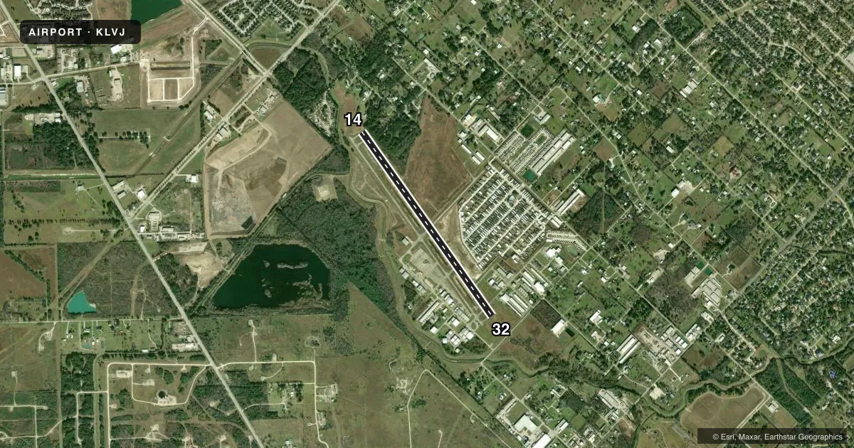
Runways & pattern
Full pagePattern entry · RWY 14
LEFT TRAFFICRunway end performance
| End | TORA | TODA | ASDA | LDA | VGSI | Approach lights | Obstruction |
|---|---|---|---|---|---|---|---|
| 14 | — | — | — | — | — | — | 50', trees, 201' from thr, 250' R of cntrln, slope 0 |
| 32 | — | — | — | — | — | — | 30', trees, 605' from thr, 40' R of cntrln, slope 13 |
Declared distances in feet. TORA = takeoff run available, TODA = takeoff distance, ASDA = accelerate-stop, LDA = landing distance.
Airport sketch
Runways drawn to scale from FAA survey coordinates, rendered over satellite imagery. Not for navigation.
Approaches & charts
Services on the field
Fuel grades, oxygen, maintenance, ramp storage and lighting — as declared to the FAA by the airport operator.
Fuel & services
- Fuel
- 100LLA
- Airframe repair
- Major
- Power plant repair
- Major
- Other services
- AVNCS,CHTR,INSTR,RNTL
Ramp & ground
- Transient storage
- Tie-down
- Hangar
- Landing fee
- No fee published
- Customs
- Not available
- Lighting schedule
- SEE RMK
- Beacon schedule
- SS-SR
- Beacon
- White / Green (civil land)(WG)
- Wind indicator
- Lighted
- Segmented circle
- Yes
Fuel & FBOs
Cheapest 100LL and Jet A on the field and nearby. Always confirm with the FBO before taxi.
Airport notes
Surface conditions, obstructions, local procedures, lighting outages and other notes published with each FAA cycle.
General notes
- RWY 14 25 FT LGTD POLES IN TREES 520 FT FM THR.
- BANNER TOWING SR-SS.
- LGTD OIL DERRICK 116 FT AGL .65 NM SE OF ARPT.
- HEL TFC INVOF ARPT.
- RWY 14 CALM WIND RWY.
- FOR CD CTC HOUSTON APCH AT 281-443-5844. TO CNL IFR CTC HOUSTON APCH AT 281-443-5888.
- RWY 14/32 SAFETY AREA IREG SFC IRRIGATION DITCHES E AND W SIDE ADJ 40 FT, 10 FT DROP.
Lighting notes
- MIRL RWY 14/32 SS-SR PRESET LOW INTST; INCR INTST & ACTVT - CTAF.
Approach & departure obstructions
- 1430 FT TREES, 0-72 FT DSTC, 90 FT L, 50 FT TREE, 150 FT DSTC, 240 R.
- 14HELS USE RIGHT-HAND TFC.
- 32HELS USE RIGHT-HAND TFC.
- 14CONTROLLING OBSTRUCTION EXCEEDS A 45 DEGREE SLOPE
- 14ALSO 13 FT RD, 418 FT DSTC, 150 FT L/R.
Other notes
- PREDATES ACT.
- ASST_MGRTREVOR@FLYPEARLAND.COM
VFR map & nearby airports
VFR sectional. Tap any ICAO chip to open that airport.
Key facts · KLVJ
Answer card- ICAO
- KLVJ
- Name
- PEARLAND RGNL
- Location
- HOUSTON, TEXAS
- Elevation
- 43.9 ft MSL
- Traffic pattern altitude
- 1,043.9 ft MSL (1,000 AGL)
- Control tower
- Non-towered (use CTAF)
- Total runways
- 1
- Longest runway
- 14/32 · 4,313 ft
- Published ILS approaches
- 0
- Published frequencies
- 5
- Magnetic variation
- 3°
- Current flight rules
- VFR
- Current wind
- 000° at 0 kt
- Favored runway now
- –
Pearland Rgnl is in Houston, Texas. Field elevation is 43.9 ft MSL. The airport has one runway, 14/32, which is 4,313 ft long. There is no control tower. No ILS approaches are published here.
Pattern altitude is not published. Use the standard 1,000 ft AGL for light piston traffic unless the current Chart Supplement or local procedures say otherwise. The on-field FBO is Pearland Regional Airport. It carries AVGAS 100LL and Jet A. For current service details, call the FBO directly at (281) 482-7551.
This is a non-towered field with Houston Approach handling IFR services. Clearance delivery is handled through Houston Approach. The published remarks also flag several items that matter on a first visit. There is a lighted oil derrick southeast of the airport. Runway 14 has trees and poles near the approach end. The runway safety area has irregular irrigation ditches on both sides with a drop adjacent to the pavement. Helicopters use right-hand traffic for both runway directions. Banner towing also occurs from sunrise to sunset. Check the current Chart Supplement before you go for any changes to procedures or local restrictions.