METAR & TAF 3T2
3T2 does not publish a METAR.
Showing the nearest reporting station: KLVJ (PEARLAND RGNL) · 5.1 NM away. Conditions at 3T2 may differ.
METAR · KLVJ
Observed 04:53Z
KLVJ 270453Z AUTO 20004KT 10SM CLR 27/24 A3001 RMK AO2 SLP162 T02720244
- Wind
- 200° @ 4 kt
- Visibility
- 10 SM
- Temp / Dew
- 27°C / 24°C
- Altimeter
- 30.01 inHg
- Clouds
- CLR
- Density alt
- 1,397 ft
- Ceiling
- Unlimited
- Rules
- VFR
Airport info & contacts
Manager on record, flight service, ARTCC, attendance schedule and pattern altitude — published by the FAA and refreshed every 28 days.
Location
- From city
- 2 NM NE
- VFR sectional
- HOUSTON
- ARTCC
- ZHU · HOUSTON
- NOTAM facility
- CXO (NOTAM-D)
Airport manager
- Name
- KRISTOFOR GIBER
- Phone
- 915-449-9100
- Address
- 8802 BELCHER, MANVEL TX 77578
Flight service · Hours
- FSS CXO
- MONTGOMERY COUNTY1-800-WX-BRIEF
- Attendance
- DALGT
Frequencies
Tap any row to copy the frequency to your clipboard.
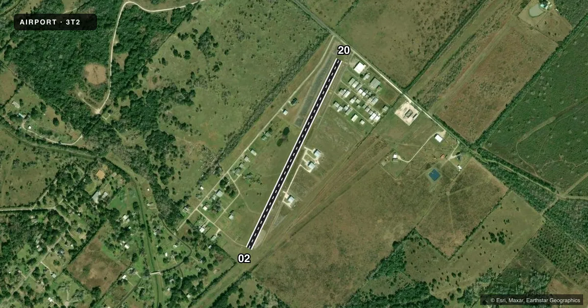
Runways & pattern
Full pagePattern entry · RWY 20
LEFT TRAFFICRunway end performance
| End | TORA | TODA | ASDA | LDA | VGSI | Approach lights | Obstruction |
|---|---|---|---|---|---|---|---|
| 02 | — | — | — | — | — | — | 20', trees, 0' from thr, 20' R of cntrln, slope 0 |
| 20 | — | — | — | — | — | — | 15', road, 143' from thr, 145' R of cntrln, slope 9 |
Declared distances in feet. TORA = takeoff run available, TODA = takeoff distance, ASDA = accelerate-stop, LDA = landing distance.
Airport sketch
Runways drawn to scale from FAA survey coordinates, rendered over satellite imagery. Not for navigation.
Approaches & charts
Services on the field
Fuel grades, oxygen, maintenance, ramp storage and lighting — as declared to the FAA by the airport operator.
Fuel & services
- Fuel
- Not available
- Airframe repair
- Not available
- Power plant repair
- Not available
Ramp & ground
- Transient storage
- Tie-down
- Hangar
- Landing fee
- No fee published
- Lighting schedule
- SS-SR
- Wind indicator
- Yes
- Segmented circle
- No
Fuel & FBOs
Cheapest 100LL and Jet A on the field and nearby. Always confirm with the FBO before taxi.
Airport notes
Surface conditions, obstructions, local procedures, lighting outages and other notes published with each FAA cycle.
General notes
- DITCH XNG RWY 20 THR.
- FIRST 400 FT OF EACH END OF RWY UNUSBL WHEN WET.
- FOR CD CTC HOUSTON APCH AT 281-443-5844 TO CNL IFR CALL 281-443-5888.
- NO TSNT TGLS.
Runway surface & condition
- 02/20SOLAR LGTS.
Approach & departure obstructions
- 20RWY 20 END MKD WITH WHITE "L" MARKERS.
- 02CONTROLLING OBSTRUCTION EXCEEDS A 45 DEGREE SLOPE.
VFR map & nearby airports
VFR sectional. Tap any ICAO chip to open that airport.
Key facts · 3T2
Answer card- ICAO
- 3T2
- Name
- WOLFE AIR PARK
- Location
- MANVEL, TEXAS
- Elevation
- 55 ft MSL
- Traffic pattern altitude
- 1,055 ft MSL (1,000 AGL)
- Control tower
- Non-towered (use CTAF)
- Total runways
- 1
- Longest runway
- 02/20 · 2,910 ft
- Published ILS approaches
- 0
- Published frequencies
- 1
- Magnetic variation
- 6°
- Current flight rules
- VFR
- Current wind
- 200° at 4 kt
- Favored runway now
- RWY 20
Wolfe Air Park sits in Manvel, Texas. Field elevation is 55 ft MSL. It has one runway. The longest runway is 2,910 ft of turf. There is no control tower. CTAF is 122.9. No ILS approaches are published here.
Pattern altitude is not published. Use the standard 1,000 ft AGL for light piston operations unless the current Chart Supplement says otherwise. The runway has solar lights. There is a ditch crossing the threshold of runway 20. The first 400 feet of each end of the runway is unusable when wet. Runway 02 also has a controlling obstruction that exceeds a 45 degree slope. That makes a careful look at the wind, surface condition and landing distance important before you commit.
No on-field FBOs are listed. Plan on confirming services with the airport operator before arrival. There is no transient touch-and-go traffic allowed. For IFR coordination, Houston Approach handles clearance delivery at the published phone number in the Chart Supplement. If you are flying this field for the first time, review the turf condition, the wet-field limits and the runway 20 threshold ditch before you go.