METAR & TAF 81D
81D does not publish a METAR.
Showing the nearest reporting station: KLBX (TEXAS GULF COAST RGNL) · 9.7 NM away. Conditions at 81D may differ.
METAR · KLBX
Observed 03:53Z
KLBX 270353Z AUTO 18005KT 10SM CLR 26/24 A3001 RMK AO1 SLP160 T02560244
- Wind
- 180° @ 5 kt
- Visibility
- 10 SM
- Temp / Dew
- 26°C / 24°C
- Altimeter
- 30.01 inHg
- Clouds
- CLR
- Density alt
- 1,246 ft
- Ceiling
- Unlimited
- Rules
- VFR
Airport info & contacts
Manager on record, flight service, ARTCC, attendance schedule and pattern altitude — published by the FAA and refreshed every 28 days.
Location
- From city
- 6 NM N
- VFR sectional
- HOUSTON
- ARTCC
- ZHU · HOUSTON
- NOTAM facility
- CXO (NOTAM-D)
Airport manager
- Name
- BRIAN BOHANNON
- Phone
- 281-731-1231
- Address
- 2720 COUNTY ROAD 49, ANGLETON TX 77515
Flight service · Hours
- FSS CXO
- MONTGOMERY COUNTY1-800-WX-BRIEF
- Attendance
- Unattended
Frequencies
Tap any row to copy the frequency to your clipboard.
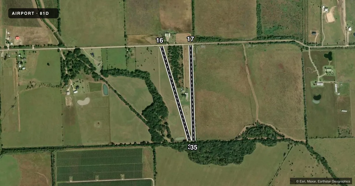
Runways & pattern
Full pagePattern entry · RWY 17
LEFT TRAFFIC| Runway | Heading (°M) | Length | Surface | Traffic |
|---|---|---|---|---|
| 16/34 | 157° / 337° | 2,261 ft | TURF | Standard L |
| 17/35Favored | 172° / 352° | 2,200 ft | TURF | Standard L |
Runway end performance
| End | TORA | TODA | ASDA | LDA | VGSI | Approach lights | Obstruction |
|---|---|---|---|---|---|---|---|
| 16 | — | — | — | — | — | — | 15', road, 18' from thr, 125' R of cntrln, slope 1 |
| 34 | — | — | — | — | — | — | 60', trees, 20' from thr, 125' R of cntrln, slope 0 |
| 17 | — | — | — | — | — | — | 15', road, 19' from thr, 125' R of cntrln, slope 1 |
| 35 | — | — | — | — | — | — | 60', trees, 20' from thr, 125' R of cntrln, slope 0 |
Declared distances in feet. TORA = takeoff run available, TODA = takeoff distance, ASDA = accelerate-stop, LDA = landing distance.
Airport sketch
Runways drawn to scale from FAA survey coordinates, rendered over satellite imagery. Not for navigation.
Approaches & charts
Services on the field
Fuel grades, oxygen, maintenance, ramp storage and lighting — as declared to the FAA by the airport operator.
Fuel & services
- Fuel
- Not available
Ramp & ground
- Transient storage
- Not published
- Landing fee
- No fee published
- Wind indicator
- Yes
- Segmented circle
- No
Fuel & FBOs
Cheapest 100LL and Jet A on the field and nearby. Always confirm with the FBO before taxi.
Airport notes
Surface conditions, obstructions, local procedures, lighting outages and other notes published with each FAA cycle.
General notes
- POWER LINES BURIED IN RWYS 16 & 17 APCH.
- RWY 16/34, 3 FT BERM AT SOUTH TH.
- RWY 16 & RWY 17, 15 FT RD ACRS RWY END.
- FOR CD CTC HOUSTON APCH AT 281-443-5844 TO CNL IFR CALL 281-443-5888.
VFR map & nearby airports
VFR sectional. Tap any ICAO chip to open that airport.
Key facts · 81D
Answer card- ICAO
- 81D
- Name
- FLYIN TIGER
- Location
- ANGLETON, TEXAS
- Elevation
- 30 ft MSL
- Traffic pattern altitude
- 1,030 ft MSL (1,000 AGL)
- Control tower
- Non-towered (use CTAF)
- Total runways
- 2
- Longest runway
- 16/34 · 2,261 ft
- Published ILS approaches
- 0
- Published frequencies
- 1
- Magnetic variation
- 6°
- Current flight rules
- VFR
- Current wind
- 180° at 5 kt
- Favored runway now
- RWY 17
FLYIN TIGER (81D) sits in Angleton, Texas. The field elevation is 30 ft MSL. It has two turf runways. The longest is runway 16/34 at 2,261 ft. Runway 17/35 is 2,200 ft. There is no control tower. CTAF is 122.9.
No ILS approaches are published here. Pattern altitude is not published, so use the standard 1,000 ft AGL for light piston operations unless the current FAA Chart Supplement says otherwise. That puts the normal pattern reference at 1,030 ft MSL based on the field elevation. Runway 16/34 has a 3-foot berm at the south threshold. Power lines are buried in the approaches to runways 16 and 17. There is also a 15-foot road across the runway end of runways 16 and 17, so pay close attention on short final and during rollout.
There are no on-field FBOs listed. Plan on verifying services with the airport operator or by phone before you go. For IFR work, clearance delivery is handled through Houston Approach at 281-443-5844. To cancel IFR, use 281-443-5888. This is a small turf field with short runways, so performance planning matters. Check the current FAA Chart Supplement for any updated remarks before departure.