METAR & TAF KLBX
Current METAR
Observed 06:53Z
KLBX 270653Z AUTO 00000KT 10SM CLR 26/24 A2999 RMK AO1 SLP153 T02560244
- Wind
- 000° @ 0 kt
- Visibility
- 10 SM
- Temp / Dew
- 26°C / 24°C
- Altimeter
- 29.99 inHg
- Clouds
- CLR
- Density alt
- 1,264 ft
- Ceiling
- Unlimited
- Rules
- VFR
Airport info & contacts
Manager on record, flight service, ARTCC, attendance schedule and pattern altitude — published by the FAA and refreshed every 28 days.
Location
- From city
- 4 NM SW
- VFR sectional
- HOUSTON
- ARTCC
- ZHU · HOUSTON
- NOTAM facility
- LBX (NOTAM-D)
Airport manager
- Name
- JEFF BILYEU
- Phone
- 979-849-5755
- Address
- 8000 AIRPORT WAY, ANGLETON TX 77515
Flight service · Hours
- FSS CXO
- MONTGOMERY COUNTY1-800-WX-BRIEF
- Attendance
- MON-FRI · 0630-1830
- SAT-SUN · 0800-1830
Frequencies
Tap any row to copy the frequency to your clipboard.
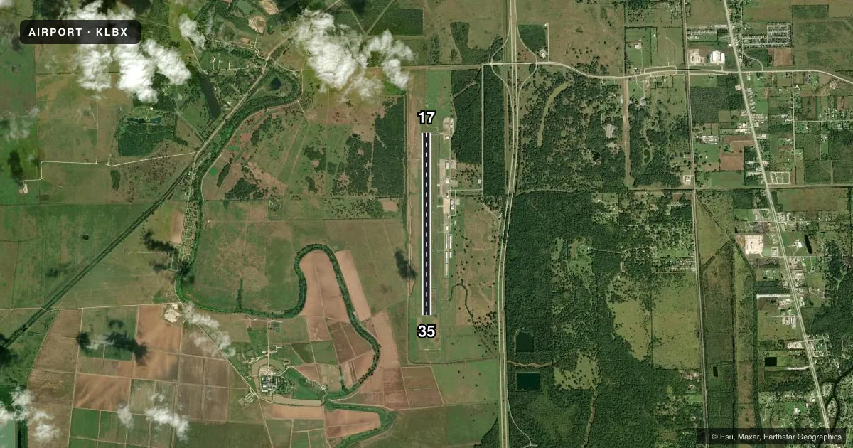
Runways & pattern
Full pagePattern entry · RWY 17
RIGHT TRAFFICRunway end performance
| End | TORA | TODA | ASDA | LDA | VGSI | Approach lights | Obstruction |
|---|---|---|---|---|---|---|---|
| 17 | 7,000' | 7,000' | 7,000' | 7,000' | PAPI 4-box left(3°) | MALSR | — |
| 35 | 7,000' | 7,000' | 7,000' | 7,000' | PAPI 4-box left(3°) | — | — |
Declared distances in feet. TORA = takeoff run available, TODA = takeoff distance, ASDA = accelerate-stop, LDA = landing distance.
Airport sketch
Runways drawn to scale from FAA survey coordinates, rendered over satellite imagery. Not for navigation.
Approaches & charts
ILS · 1
Services on the field
Fuel grades, oxygen, maintenance, ramp storage and lighting — as declared to the FAA by the airport operator.
Fuel & services
- Fuel
- 100LLA
- Oxygen (bottled)
- Low pressure
- Airframe repair
- Minor
- Power plant repair
- Major
- Other services
- CHTR,INSTR,RNTL
Ramp & ground
- Transient storage
- Tie-down
- Hangar
- Landing fee
- No fee published
- Lighting schedule
- SEE RMK
- Beacon schedule
- SS-SR
- Beacon
- White / Green (civil land)(WG)
- Wind indicator
- Lighted
- Segmented circle
- Yes
Fuel & FBOs
Cheapest 100LL and Jet A on the field and nearby. Always confirm with the FBO before taxi.
Airport notes
Surface conditions, obstructions, local procedures, lighting outages and other notes published with each FAA cycle.
General notes
- ACR OPNS INVOLVING ACFT WITH MORE THAN 30 PSGRS ARE NOT AUZD IN EXCESS OF 15 MIN BEFORE OR AFT SKED ARR OR DEP TIMES WITHOUT PRIOR COORDINATION WITH AMGR & CONFIRMATION THAT ARFF SVCS ARE AVBL PRIOR TO LNDG OR TKOF.
- FOR CD CTC HOUSTON APCH AT 281-443-5844. TO CNL IFR CTC HOUSTON APCH AT 281-443-5888.
Lighting notes
- MIRL RWY 17/35 PRESET LOW INTST; TO INCR INTST & ACTVT MALSR RWY 17 - CTAF. PAPI RWYS 17 & 35 OPR CONSLY.
Fuel notes
- 100LL100LL FUEL AVBL 24 HRS SELF SERVICE. FOR JET A FUEL AFT HRS CALL 979-319-2740.
Runway surface & condition
- 17/35PCR VALUE: 303/R/B/W/U
Other notes
- THIS AIRPORT HAS BEEN SURVEYED BY THE NATIONAL GEODETIC SURVEY.
- ARPT LCTD 4.6 NM NW OF LAKE JACKSON.
- MANAGERALSO 979-849-5756.
VFR map & nearby airports
VFR sectional. Tap any ICAO chip to open that airport.
Key facts · KLBX
Answer card- ICAO
- KLBX
- Name
- TEXAS GULF COAST RGNL
- Location
- ANGLETON/LAKE JACKSON, TEXAS
- Elevation
- 25.2 ft MSL
- Traffic pattern altitude
- 1,025.2 ft MSL (1,000 AGL)
- Control tower
- Non-towered (use CTAF)
- Total runways
- 1
- Longest runway
- 17/35 · 7,000 ft
- Published ILS approaches
- 1
- Published frequencies
- 5
- Magnetic variation
- 5°
- Current flight rules
- VFR
- Current wind
- 000° at 0 kt
- Favored runway now
- –
Texas Gulf Coast Rgnl is in Angleton and Lake Jackson, Texas. The field sits at 25.2 ft MSL. It has one runway. Runway 17/35 is 7,000 ft of concrete, so it gives you solid room for piston work and many light turbine arrivals. There is no control tower. Clearance delivery is handled through Houston Approach. The airport has one ILS approach on runway 17. Pattern altitude is not published, so use the standard 1,000 ft AGL for light piston traffic unless ATC or the current FAA Chart Supplement says otherwise.
The on-field FBO is Texas Gulf Coast Regional Airport. It carries 100LL, Jet A and Jet A Prist. Published remarks say 100LL is available 24 hours self service. They also note that after-hours Jet A support is available by phone. Runway 17/35 has medium intensity lights preset to low. Use CTAF to raise intensity and to activate the medium intensity approach lighting system with runway alignment indicator lights on runway 17. PAPI is available on both runway ends and operates continuously. This field is close to Lake Jackson. Expect local traffic and plan your arrival with the Houston Approach frequencies in mind. If you are bringing a larger aircraft with more than 30 passengers, check the airport manager before you go.