METAR & TAF 7R9
7R9 does not publish a METAR.
Showing the nearest reporting station: KLBX (TEXAS GULF COAST RGNL) · 4.7 NM away. Conditions at 7R9 may differ.
METAR · KLBX
Observed 18:53Z
KLBX 251853Z AUTO 21005KT 10SM CLR 33/22 A3009 RMK AO1 SLP189 T03280222
- Wind
- 210° @ 5 kt
- Visibility
- 10 SM
- Temp / Dew
- 33°C / 22°C
- Altimeter
- 30.09 inHg
- Clouds
- CLR
- Density alt
- 1,975 ft
- Ceiling
- Unlimited
- Rules
- VFR
Airport info & contacts
Manager on record, flight service, ARTCC, attendance schedule and pattern altitude — published by the FAA and refreshed every 28 days.
Location
- From city
- 2 NM E
- VFR sectional
- HOUSTON
- ARTCC
- ZHU · HOUSTON
- NOTAM facility
- CXO (NOTAM-D)
Airport manager
- Name
- CHARLIE WALKER
- Phone
- 979-551-4242
- Address
- 1518 SANDPIPER, ANGLETON TX 77515
Flight service · Hours
- FSS CXO
- MONTGOMERY COUNTY1-800-WX-BRIEF
- Attendance
- Unattended
Frequencies
Tap any row to copy the frequency to your clipboard.
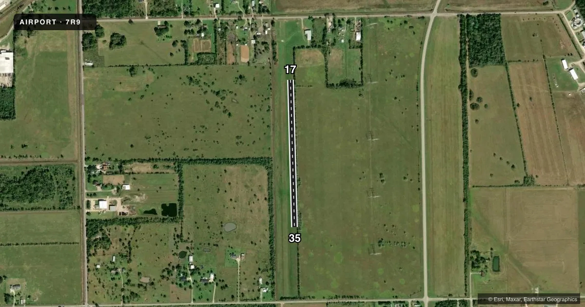
Runways & pattern
Full pagePattern entry · RWY 17
LEFT TRAFFICRunway end performance
| End | TORA | TODA | ASDA | LDA | VGSI | Approach lights | Obstruction |
|---|---|---|---|---|---|---|---|
| 17 | — | — | — | — | — | — | 32', tree, 184' from thr, 124' R of cntrln, slope 5 |
| 35 | — | — | — | — | — | — | 35', trees, 35' from thr, 125' R of cntrln, slope 1 |
Declared distances in feet. TORA = takeoff run available, TODA = takeoff distance, ASDA = accelerate-stop, LDA = landing distance.
Airport sketch
Runways drawn to scale from FAA survey coordinates, rendered over satellite imagery. Not for navigation.
Approaches & charts
Services on the field
Fuel grades, oxygen, maintenance, ramp storage and lighting — as declared to the FAA by the airport operator.
Fuel & services
- Fuel
- Not available
- Airframe repair
- Not available
- Power plant repair
- Not available
Ramp & ground
- Transient storage
- Tie-down
- Landing fee
- No fee published
- Customs
- Not available
- Wind indicator
- Yes
- Segmented circle
- No
Fuel & FBOs
Cheapest 100LL and Jet A on the field and nearby. Always confirm with the FBO before taxi.
Airport notes
Surface conditions, obstructions, local procedures, lighting outages and other notes published with each FAA cycle.
General notes
- FOR CD CTC HOUSTON APCH AT 281-443-5844 TO CNL IFR CALL 281-443-5888.
- RWY DEFINED BY MOWING. RWY ROUGH & UNEVEN.
Approach & departure obstructions
- 17RWY END MKD W/CONC.PAD.
Other notes
- 17/35RWY ROUGH & UNEVEN.
VFR map & nearby airports
VFR sectional. Tap any ICAO chip to open that airport.
Key facts · 7R9
Answer card- ICAO
- 7R9
- Name
- BAILES
- Location
- ANGLETON, TEXAS
- Elevation
- 21 ft MSL
- Traffic pattern altitude
- 1,021 ft MSL (1,000 AGL)
- Control tower
- Non-towered (use CTAF)
- Total runways
- 1
- Longest runway
- 17/35 · 2,060 ft
- Published ILS approaches
- 0
- Published frequencies
- 1
- Magnetic variation
- 6°
- Current flight rules
- VFR
- Current wind
- 210° at 5 kt
- Favored runway now
- RWY 17
BAILES (7R9) sits near Angleton, Texas. Field elevation is 21 ft MSL. The airport has one runway. Runway 17/35 is 2,060 ft of turf, so plan for a short-field surface and check conditions before you go. No control tower is published. CTAF is 122.9.
No ILS approaches are published here. Pattern altitude is not published in the facts, so use the current FAA Chart Supplement for the published traffic pattern information before arrival. The runway headings are magnetic. Runway 17 is marked at the end with a concrete pad. Runway 35 is marked with white tires north of the south boundary tree line. The runway markings are obscured by vegetation, so a first-time arrival should be ready to identify the strip visually before committing.
There are no on-field FBOs listed in the facts. Contact the airport operator directly before arrival, or call the field on CTAF or UNICOM for current FBO availability. For IFR work, clearance delivery is handled through Houston Approach at 281-443-5844. If you need to cancel IFR, use 281-443-5888. The field is low and coastal. Expect to pay attention to soft-field technique, runway condition and local visibility before you launch.