METAR & TAF KHPY
KHPY does not publish a METAR.
Showing the nearest reporting station: KEFD (ELLINGTON) · 15.2 NM away. Conditions at KHPY may differ.
METAR · KEFD
Observed 07:54Z
KEFD 270754Z 21003KT 10SM CLR 26/24 A2997
- Wind
- 210° @ 3 kt
- Visibility
- 10 SM
- Temp / Dew
- 26°C / 24°C
- Altimeter
- 29.97 inHg
- Clouds
- CLR
- Density alt
- 1,300 ft
- Ceiling
- Unlimited
- Rules
- VFR
Airport info & contacts
Manager on record, flight service, ARTCC, attendance schedule and pattern altitude — published by the FAA and refreshed every 28 days.
Location
- From city
- 3 NM N
- VFR sectional
- HOUSTON
- ARTCC
- ZHU · HOUSTON
- NOTAM facility
- CXO (NOTAM-D)
Airport manager
- Name
- CHARLES DANLEY
- Phone
- 713-303-8638
- Address
- 5600 BARKALOO ROAD, BAYTOWN TX 77521
Flight service · Hours
- FSS CXO
- MONTGOMERY COUNTY1-800-WX-BRIEF
- Attendance
- 0800-1700
Frequencies
Tap any row to copy the frequency to your clipboard.
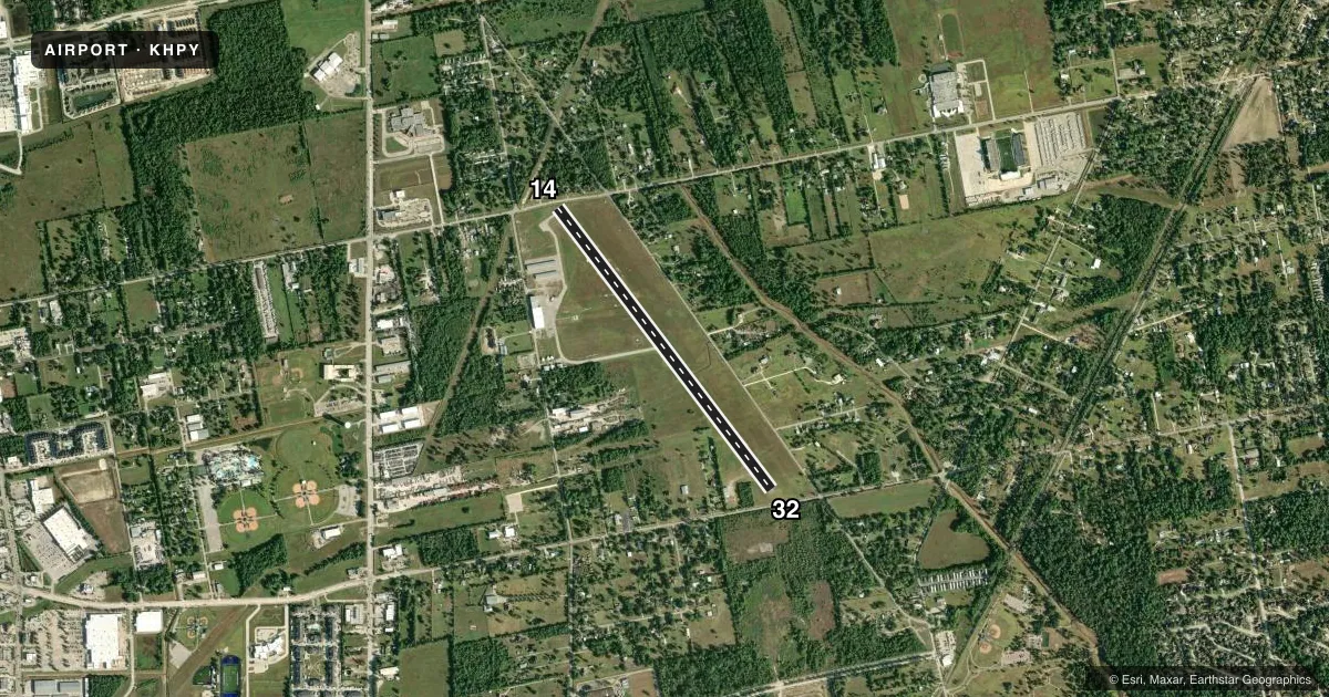
Runways & pattern
Full pagePattern entry · RWY 14
LEFT TRAFFICRunway end performance
| End | TORA | TODA | ASDA | LDA | VGSI | Approach lights | Obstruction |
|---|---|---|---|---|---|---|---|
| 14 | 4,088' | 4,088' | 4,088' | 3,320' | PAPI 2-box left(3°) | — | 15', road, 201' from thr, 131' R of cntrln, slope 0 |
| 32 | 4,003' | 4,003' | 4,003' | 3,283' | PAPI 2-box left(3°) | — | 20', pline, 200' from thr, 0' R of cntrln, slope 0 |
Declared distances in feet. TORA = takeoff run available, TODA = takeoff distance, ASDA = accelerate-stop, LDA = landing distance.
Airport sketch
Runways drawn to scale from FAA survey coordinates, rendered over satellite imagery. Not for navigation.
Approaches & charts
Services on the field
Fuel grades, oxygen, maintenance, ramp storage and lighting — as declared to the FAA by the airport operator.
Fuel & services
- Fuel
- 100LLA+
- Airframe repair
- Major
- Power plant repair
- Major
- Other services
- AMB,INSTR
Ramp & ground
- Transient storage
- Tie-down
- Hangar
- Landing fee
- No fee published
- Customs
- Not available
- Lighting schedule
- SEE RMK
- Beacon schedule
- SS-SR
- Beacon
- White / Green (civil land)(WG)
- Wind indicator
- Lighted
- Segmented circle
- Yes
Fuel & FBOs
Cheapest 100LL and Jet A on the field and nearby. Always confirm with the FBO before taxi.
Airport notes
Surface conditions, obstructions, local procedures, lighting outages and other notes published with each FAA cycle.
General notes
- FOR CD CTC HOUSTON APCH AT 281-443-5844 TO CNL IFR CALL 281-443-5888.
Lighting notes
- ACTVT REIL RWY 14 & 32; PAPI RWY 14 & 32; MIRL RWY 14/32 - CTAF.
Approach & departure obstructions
- 1415 FT RD 0 FT DSTC, 140 FT L ACRS APCH.
- 3215 FT RD 126 FT DSTC ACRS APCH.
- 14APCH SLOPE 12:1 TO DSPLCD THR OVR 40 FT TREES, 485 FT DSTC, 200 L.
- 32APCH SLOPE 13:1 TO DSPLCD THR OVR 33 FT TREES, 463 FT DSTC, 260 FT L.
Other notes
- THIS AIRPORT HAS BEEN SURVEYED BY THE NATIONAL GEODETIC SURVEY.
- PRE DATES THE ACT.
- MANAGER713-303-8638 MGR CELL.
VFR map & nearby airports
VFR sectional. Tap any ICAO chip to open that airport.
Key facts · KHPY
Answer card- ICAO
- KHPY
- Name
- BAYTOWN
- Location
- BAYTOWN, TEXAS
- Elevation
- 33.8 ft MSL
- Traffic pattern altitude
- 1,033.8 ft MSL (1,000 AGL)
- Control tower
- Non-towered (use CTAF)
- Total runways
- 1
- Longest runway
- 14/32 · 4,334 ft
- Published ILS approaches
- 0
- Published frequencies
- 4
- Magnetic variation
- 3°
- Current flight rules
- VFR
- Current wind
- 210° at 3 kt
- Favored runway now
- RWY 14
Baytown Airport (KHPY) sits in Baytown, Texas at 33.8 ft MSL. It has one runway, 14/32, which is 4,334 ft long. The field is non-towered. Pattern altitude is not published, so use the standard 1,000 ft AGL for light piston operations unless the current Chart Supplement says otherwise.
No ILS approaches are published here. IFR pilots should plan on Houston Approach for clearance delivery and approach control. The published remarks also note runway lighting on 14/32 with medium intensity lights controlled by CTAF. Runway end identifier lights and PAPI are installed on both ends. That helps at night. You still want to brief the runway environment before arrival.
Raceco is on the field. It carries 100LL, Jet A and Jet A Prist. If you need current ramp, fuel, or service details, call the FBO directly before departure. There are published obstructions near both runway ends. Runway 32 has trees, a road and a displaced-threshold slope note. Runway 14 has a road, a fence and trees on the approach path. First-time visitors should pay close attention to the runway picture and the latest Chart Supplement remarks before coming in.