METAR & TAF 54T
54T does not publish a METAR.
Showing the nearest reporting station: KEFD (ELLINGTON) · 18.7 NM away. Conditions at 54T may differ.
METAR · KEFD
Observed 04:54Z
KEFD 270454Z 19006KT 10SM CLR 27/25 A2999
- Wind
- 190° @ 6 kt
- Visibility
- 10 SM
- Temp / Dew
- 27°C / 25°C
- Altimeter
- 29.99 inHg
- Clouds
- CLR
- Density alt
- 1,394 ft
- Ceiling
- Unlimited
- Rules
- VFR
Airport info & contacts
Manager on record, flight service, ARTCC, attendance schedule and pattern altitude — published by the FAA and refreshed every 28 days.
Location
- From city
- 7 NM E
- VFR sectional
- HOUSTON
- ARTCC
- ZHU · HOUSTON
- NOTAM facility
- CXO (NOTAM-D)
Airport manager
- Name
- DENNIS J. COX
- Phone
- 512-825-9771
- Address
- 15506 SUNDOWNER, BEACH CITY TX 77523
Flight service · Hours
- FSS CXO
- MONTGOMERY COUNTY1-800-WX-BRIEF
- Attendance
- MON-FRI · 0800-1800
Frequencies
Tap any row to copy the frequency to your clipboard.
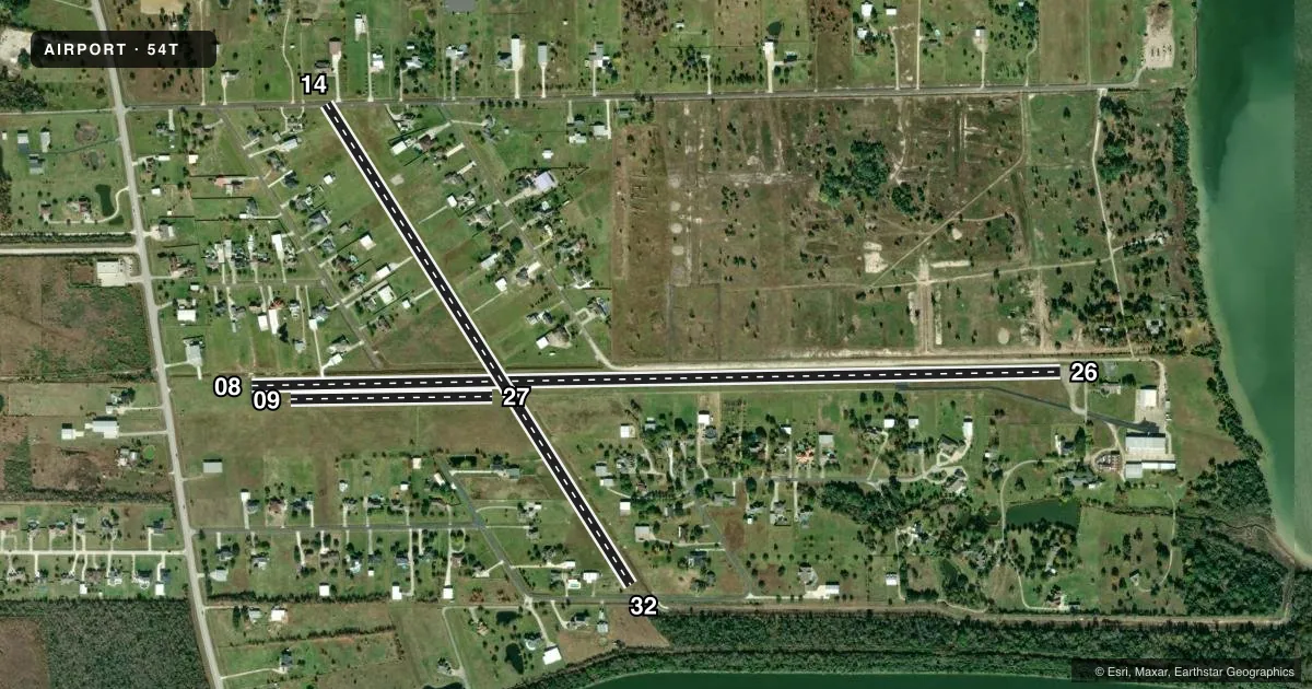
Runways & pattern
Full pagePattern entry · RWY 14
LEFT TRAFFIC| Runway | Heading (°M) | Length | Surface | Traffic |
|---|---|---|---|---|
| 08/26 | 84° / 264° | 5,035 ft | ASPH | Standard L |
| 14/32Favored | 143° / 323° | 3,532 ft | TURF | Standard L |
| 09/27 | 84° / 264° | 1,255 ft | TURF | Standard L |
Runway end performance
| End | TORA | TODA | ASDA | LDA | VGSI | Approach lights | Obstruction |
|---|---|---|---|---|---|---|---|
| 08 | — | — | — | — | — | — | 20', bldg, 300' from thr, 170' R of cntrln, slope 5 |
| 26 | — | — | — | — | — | — | 10', road, 201' from thr, 0' R of cntrln, slope 0 |
| 14 | — | — | — | — | — | — | 15', road, 0' from thr, 120' R of cntrln, slope 0 |
| 32 | — | — | — | — | — | — | 17', road, 25' from thr, 50' R of cntrln, slope 1 |
Declared distances in feet. TORA = takeoff run available, TODA = takeoff distance, ASDA = accelerate-stop, LDA = landing distance.
Airport sketch
Runways drawn to scale from FAA survey coordinates, rendered over satellite imagery. Not for navigation.
Approaches & charts
Services on the field
Fuel grades, oxygen, maintenance, ramp storage and lighting — as declared to the FAA by the airport operator.
Fuel & services
- Fuel
- 100LLA
- Airframe repair
- Major
- Power plant repair
- Major
- Other services
- SALES
Ramp & ground
- Transient storage
- Tie-down
- Hangar
- Landing fee
- No fee published
- Lighting schedule
- SS-SR
- Beacon schedule
- SS-SR
- Beacon
- White / Green (civil land)(WG)
- Wind indicator
- Yes
- Segmented circle
- No
Fuel & FBOs
Cheapest 100LL and Jet A on the field and nearby. Always confirm with the FBO before taxi.
Airport notes
Surface conditions, obstructions, local procedures, lighting outages and other notes published with each FAA cycle.
General notes
- PARTIAL PARALLEL TWY FR 26 DSPLCD THR NOT SUITABLE FOR ACFT.
- RWY 08 37 FT PLINE MKD & LGTD, 460 FT FM RWY END
- FOR CD CTC HOUSTON APCH AT 281-443-5844 TO CNL IFR CALL 281-443-5888.
Fuel notes
- AFOR FUEL CALL 281-383-2320.
Runway surface & condition
- 08/26LIRL LCTD 15 FT FM RWY EDGE WEST, 4000 FT LGTD.
- 08/26EAST 1100 FT 60 FT WIDE.
Approach & departure obstructions
- 2610 FT RD 0-200 FT DSTC, 60 FT R CNTRLN; 4 FT FENCE 0-200 FT DSTC 92 FT R CNTRLN.
- 08RWY MKGS NSTD, MKGS DO NOT MATCH PUBLISHED DIMENSIONS.
- 26DSPLCD THR MKGS NSTD, NO ARROWS, NO ARROWHEADS.
- 26OBSTN CLNC SLOPE 0:1 TO DSPLCD THR; 4 FT FENCE, 15 FT RD; 18:1 OVR 85 FT WATER TWR 1600 FT DSTC, 185 FT L.
VFR map & nearby airports
VFR sectional. Tap any ICAO chip to open that airport.
Key facts · 54T
Answer card- ICAO
- 54T
- Name
- RWJ AIRPARK
- Location
- BAYTOWN, TEXAS
- Elevation
- 33 ft MSL
- Traffic pattern altitude
- 1,033 ft MSL (1,000 AGL)
- Control tower
- Non-towered (use CTAF)
- Total runways
- 3
- Longest runway
- 08/26 · 5,035 ft
- Published ILS approaches
- 0
- Published frequencies
- 4
- Magnetic variation
- 5°
- Current flight rules
- VFR
- Current wind
- 190° at 6 kt
- Favored runway now
- RWY 14
RWJ Airpark sits in Baytown, Texas. Field elevation is 33 ft MSL. The airport has two runways. The longest is 08/26 at 5,035 ft. Runway 14/32 is turf at 3,532 ft. There is no control tower. No ILS approaches are published here. Pattern altitude is not published, so use the current Chart Supplement or local traffic advisories before you arrive.
Bay Area Aviation is on the field. It carries 100LL and Jet A. Call (281) 383-2320 for fuel service and current ramp details. The published remarks matter here. The taxiway is too narrow for some aircraft. Runway 08 also has a marked and lighted power line near the departure end. Runway 08/26 has low intensity lights on the west side. The runway is lighted for 4,000 ft.
This is a good airport to brief carefully before arrival. The field has nonstandard markings on both ends of 08/26. Runway 14 and 26 have displaced threshold obstacles in the published remarks. If you are bringing a larger airplane, check taxi width and runway condition before you commit. Houston Approach handles clearance delivery and IFR cancellation. For current noise or curfew rules, check the current FAA Chart Supplement before flying in.