METAR & TAF T90
T90 does not publish a METAR.
Showing the nearest reporting station: KBMT (BEAUMONT MUNI) · 18.8 NM away. Conditions at T90 may differ.
METAR · KBMT
Observed 07:15Z
KBMT 270715Z AUTO 00000KT 10SM CLR 24/23 A2998 RMK AO2 T02430232
- Wind
- 000° @ 0 kt
- Visibility
- 10 SM
- Temp / Dew
- 24°C / 23°C
- Altimeter
- 29.98 inHg
- Clouds
- CLR
- Density alt
- 1,036 ft
- Ceiling
- Unlimited
- Rules
- VFR
Airport info & contacts
Manager on record, flight service, ARTCC, attendance schedule and pattern altitude — published by the FAA and refreshed every 28 days.
Location
- From city
- 3 NM W
- VFR sectional
- HOUSTON
- ARTCC
- ZHU · HOUSTON
- NOTAM facility
- CXO (NOTAM-D)
Airport manager
- Name
- RONNIE BROWN
- Phone
- 409-267-2719
- Address
- PO BOX 938, ANAHUAC TX 77514
Flight service · Hours
- FSS CXO
- MONTGOMERY COUNTY1-800-WX-BRIEF
- Attendance
- Unattended
Frequencies
Tap any row to copy the frequency to your clipboard.
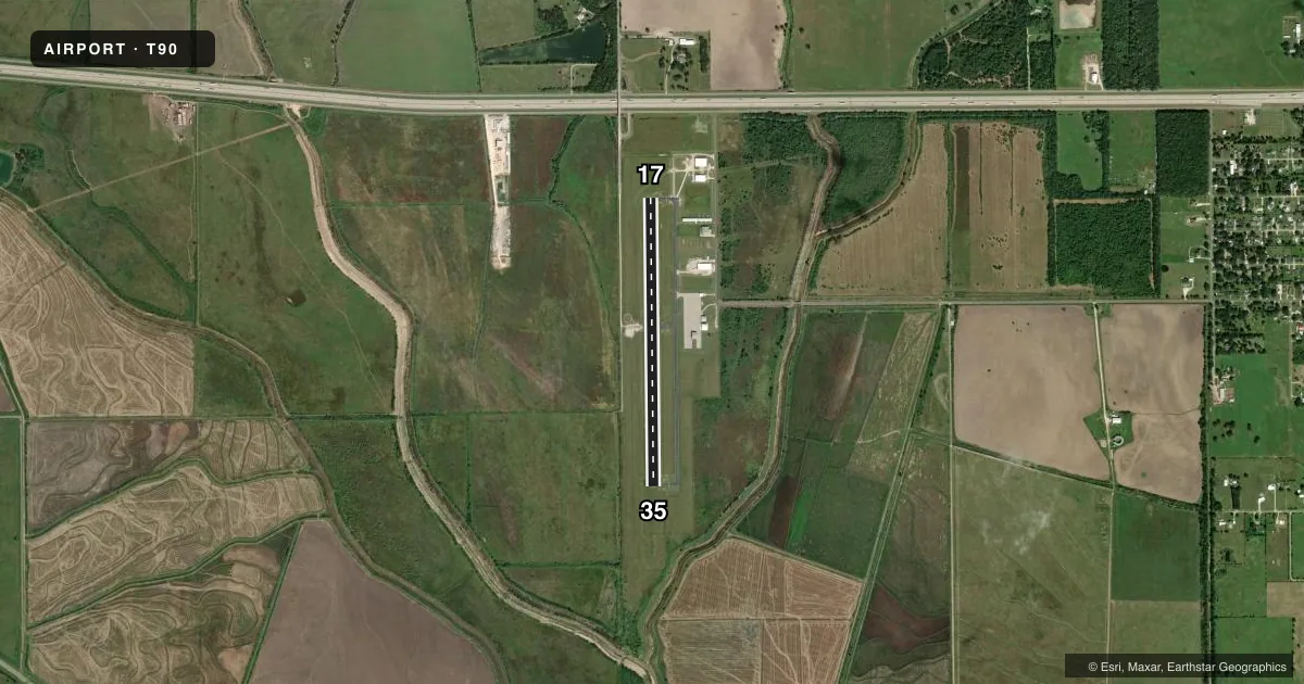
Runways & pattern
Full pagePattern entry · RWY 17
LEFT TRAFFICRunway end performance
| End | TORA | TODA | ASDA | LDA | VGSI | Approach lights | Obstruction |
|---|---|---|---|---|---|---|---|
| 17 | — | — | — | — | PAPI 2-box left(3°) | — | 70', trees, 1500' from thr, 250' R of cntrln, slope 18 |
| 35 | — | — | — | — | PAPI 2-box left(3°) | — | — |
Declared distances in feet. TORA = takeoff run available, TODA = takeoff distance, ASDA = accelerate-stop, LDA = landing distance.
Airport sketch
Runways drawn to scale from FAA survey coordinates, rendered over satellite imagery. Not for navigation.
Approaches & charts
Services on the field
Fuel grades, oxygen, maintenance, ramp storage and lighting — as declared to the FAA by the airport operator.
Fuel & services
- Fuel
- 100LLA+
- Other services
- AGRI
Ramp & ground
- Transient storage
- Tie-down
- Lighting schedule
- SEE RMK
- Beacon schedule
- SS-SR
- Beacon
- White / Green (civil land)(WG)
- Wind indicator
- Lighted
- Segmented circle
- Yes
Fuel & FBOs
Cheapest 100LL and Jet A on the field and nearby. Always confirm with the FBO before taxi.
Airport notes
Surface conditions, obstructions, local procedures, lighting outages and other notes published with each FAA cycle.
General notes
- FOR CD CTC HOUSTON APCH AT 281-443-5844. TO CNL IFR CALL 281-443-5888.
- EXTSV AERIAL AG OPS.
Lighting notes
- MIRL RWY 17/35 PRESET LOW INTST DUSK-2330, TO INCR INTST OR ACTVT AFT 2330 - CTAF.
Fuel notes
- 100LLFUEL SELF-SVC.
VFR map & nearby airports
VFR sectional. Tap any ICAO chip to open that airport.
Key facts · T90
Answer card- ICAO
- T90
- Name
- CHAMBERS COUNTY/WINNIE STOWELL
- Location
- WINNIE/STOWELL, TEXAS
- Elevation
- 24.2 ft MSL
- Traffic pattern altitude
- 1,024.2 ft MSL (1,000 AGL)
- Control tower
- Non-towered (use CTAF)
- Total runways
- 1
- Longest runway
- 17/35 · 3,600 ft
- Published ILS approaches
- 0
- Published frequencies
- 3
- Magnetic variation
- 1°
- Current flight rules
- VFR
- Current wind
- 000° at 0 kt
- Favored runway now
- –
Chambers County/Winnie Stowell sits in Winnie/Stowell, Texas. Field elevation is 24.2 ft MSL. The airport has one runway, 17/35, at 3,600 ft. It is not towered. Pattern altitude is not published, so use the standard 1,000 ft AGL for light piston operations unless the current Chart Supplement says otherwise.
No ILS approaches are published here. The field uses CTAF 122.9. Houston Approach handles clearance delivery and IFR coordination. The published remarks also say the runway lights on 17/35 are preset to low intensity from dusk to 2330. After 2330, or if you need brighter lights earlier, key the CTAF to change intensity. Fuel on the field is at Chambers County Airport. It carries self-serve 100LL and JET A. For a first-time arrival, watch the low field elevation and coastal Texas weather. This is a short single-runway airport, so plan your spacing early and verify the current Chart Supplement for any changes to local procedures or airspace before you go.