METAR & TAF KBMT
Current METAR
Observed 08:55Z
KBMT 270855Z AUTO 00000KT 10SM CLR 24/23 A2997 RMK AO2 T02440232
- Wind
- 000° @ 0 kt
- Visibility
- 10 SM
- Temp / Dew
- 24°C / 23°C
- Altimeter
- 29.97 inHg
- Clouds
- CLR
- Density alt
- 1,058 ft
- Ceiling
- Unlimited
- Rules
- VFR
Airport info & contacts
Manager on record, flight service, ARTCC, attendance schedule and pattern altitude — published by the FAA and refreshed every 28 days.
Location
- From city
- 6 NM W
- VFR sectional
- HOUSTON
- ARTCC
- ZHU · HOUSTON
- NOTAM facility
- CXO (NOTAM-D)
Airport manager
- Name
- CHRIS MEAUX
- Phone
- 409-866-0084
- Address
- 455 KEITH RD, BEAUMONT TX 77713
Flight service · Hours
- FSS CXO
- MONTGOMERY COUNTY1-800-WX-BRIEF
- Attendance
- 0700-1900
Frequencies
Tap any row to copy the frequency to your clipboard.
Runways & pattern
Full pagePattern entry · RWY 13
RIGHT TRAFFICRunway end performance
| End | TORA | TODA | ASDA | LDA | VGSI | Approach lights | Obstruction |
|---|---|---|---|---|---|---|---|
| 13 | — | — | — | — | PAPI 4-box left(3°) | — | 45', pline, 745' from thr, 300' R of cntrln, slope 12 |
| 31 | — | — | — | — | PAPI 4-box left(4°) | — | 15', road, 350' from thr, 260' R of cntrln, slope 10 |
Declared distances in feet. TORA = takeoff run available, TODA = takeoff distance, ASDA = accelerate-stop, LDA = landing distance.
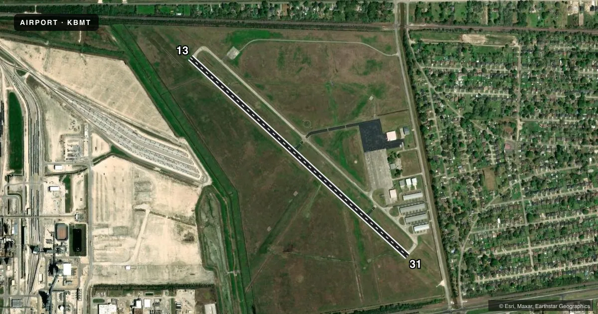
Airport sketch
Runways drawn to scale from FAA survey coordinates, rendered over satellite imagery. Not for navigation.
Approaches & charts
Services on the field
Fuel grades, oxygen, maintenance, ramp storage and lighting — as declared to the FAA by the airport operator.
Fuel & services
- Fuel
- 100LLA
- Oxygen (bulk)
- Not available
- Airframe repair
- Major
- Power plant repair
- Major
- Other services
- AMB,INSTR,RNTL
Ramp & ground
- Transient storage
- Tie-down
- Hangar
- Landing fee
- No fee published
- Customs
- Not available
- Lighting schedule
- SEE RMK
- Beacon schedule
- SS-SR
- Beacon
- White / Green (civil land)(WG)
- Wind indicator
- Lighted
- Segmented circle
- Yes
Fuel & FBOs
Cheapest 100LL and Jet A on the field and nearby. Always confirm with the FBO before taxi.
Airport notes
Surface conditions, obstructions, local procedures, lighting outages and other notes published with each FAA cycle.
General notes
- FOR CD CTC HOUSTON APCH AT 281-443-5844. TO CNL IFR CTC HOUSTON APCH AT 281-443-5888.
Lighting notes
- DUSK-DAWN. MIRL RWY 13/31 PRESET LOW INTST; TO INCR INTST ACTVT - CTAF.
Approach & departure obstructions
- 13APCH SLOPE 24:1 TO DSPLCD THR.
- 31APCH SLOPE 16:1 TO DSPLCD THR OVR 50 FT TREE, 817 FT DSTC.
- 1345 FT PLINE, 745 FT DSTC, 300 FT L.
Other notes
- PREDATES ACT.
- MANAGERAMGR CELL 409-679-0222
VFR map & nearby airports
VFR sectional. Tap any ICAO chip to open that airport.
Key facts · KBMT
Answer card- ICAO
- KBMT
- Name
- BEAUMONT MUNI
- Location
- BEAUMONT, TEXAS
- Elevation
- 31.9 ft MSL
- Traffic pattern altitude
- 1,031.9 ft MSL (1,000 AGL)
- Control tower
- Non-towered (use CTAF)
- Total runways
- 1
- Longest runway
- 13/31 · 4,001 ft
- Published ILS approaches
- 0
- Published frequencies
- 5
- Magnetic variation
- 4°
- Current flight rules
- VFR
- Current wind
- 000° at 0 kt
- Favored runway now
- –
Beaumont Muni sits in Beaumont, Texas at 31.9 ft MSL. The field has one runway. Runway 13/31 is 4,001 ft long with asphalt pavement. There is no control tower. Pattern altitude is not published, so use the standard 1,000 ft AGL for light piston traffic unless ATC or the Chart Supplement says otherwise.
No ILS approaches are published here. Houston Approach handles clearance delivery and IFR coordination. For clearance delivery, the published remarks direct you to Houston Approach. If you need to cancel IFR, use Houston Approach as well. The airport has one on-field FBO, Beaumont Municipal Airport. It carries 100LL, Jet A and Jet A Prist. 100LL is available 24 hours through self-service.
A few operational items matter here. Runway 13 has a power line near the approach path. Runway 31 has a tree near the approach path. The runway lights are preset to low intensity from dusk to dawn. Use the CTAF to increase lighting intensity. Deer are reported on and near the airport. Keep a sharp scan on taxi, takeoff and landing. If you are planning a first trip in, brief the runway environment. Watch the displaced threshold notes. Check the current FAA Chart Supplement for any updates before departure.