METAR & TAF T00
T00 does not publish a METAR.
Showing the nearest reporting station: KEFD (ELLINGTON) · 27.6 NM away. Conditions at T00 may differ.
METAR · KEFD
Observed 22:54Z
KEFD 262254Z 16013KT 10SM FEW040 33/25 A2996
- Wind
- 160° @ 13 kt
- Visibility
- 10 SM
- Temp / Dew
- 33°C / 25°C
- Altimeter
- 29.96 inHg
- Clouds
- FEW
- Density alt
- 2,137 ft
- Ceiling
- Unlimited
- Rules
- VFR
Airport info & contacts
Manager on record, flight service, ARTCC, attendance schedule and pattern altitude — published by the FAA and refreshed every 28 days.
Location
- From city
- 1 NM E
- VFR sectional
- HOUSTON
- ARTCC
- ZHU · HOUSTON
- NOTAM facility
- CXO (NOTAM-D)
Airport manager
- Name
- RONNIE BROWN
- Phone
- 409-267-2719
- Address
- 336 AIRPORT RD, PO BOX 938, ANAHUAC TX 77514
Flight service · Hours
- FSS CXO
- MONTGOMERY COUNTY1-800-WX-BRIEF
- Attendance
- MON-FRI · 0800-1700
Frequencies
Tap any row to copy the frequency to your clipboard.
Runways & pattern
Full pagePattern entry · RWY 17
LEFT TRAFFIC| Runway | Heading (°M) | Length | Surface | Traffic |
|---|---|---|---|---|
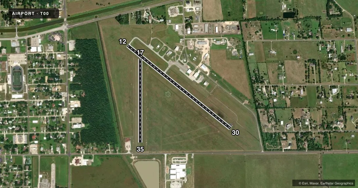
| 12/30 | 124° / 304° | 3,005 ft | ASPH | 30 R |
| 17/35Favored | 175° / 355° | 1,900 ft | TURF | 35 R |
Runway end performance
| End | TORA | TODA | ASDA | LDA | VGSI | Approach lights | Obstruction |
|---|---|---|---|---|---|---|---|
| 12 | — | — | — | — | PAPI 2-box left(4°) | — | 34', pole, 884' from thr, 160' R of cntrln, slope 20 |
| 30 | — | — | — | — | — | — | 30', tree, 880' from thr, 280' R of cntrln, slope 22 |
| 17 | — | — | — | — | — | — | 60', trees, 890' from thr, 90' R of cntrln, slope 14 |
| 35 | — | — | — | — | — | — | 17', road, 230' from thr, 0' R of cntrln, slope 13 |
Declared distances in feet. TORA = takeoff run available, TODA = takeoff distance, ASDA = accelerate-stop, LDA = landing distance.
Airport sketch
Runways drawn to scale from FAA survey coordinates, rendered over satellite imagery. Not for navigation.
Approaches & charts
Services on the field
Fuel grades, oxygen, maintenance, ramp storage and lighting — as declared to the FAA by the airport operator.
Fuel & services
- Fuel
- 100LLAA1+
- Oxygen (bottled)
- Not available
- Oxygen (bulk)
- Not available
- Other services
- AGRI
Ramp & ground
- Transient storage
- Tie-down
- Landing fee
- No fee published
- Customs
- Not available
- Lighting schedule
- SEE RMK
- Beacon schedule
- SS-SR
- Beacon
- White / Green (civil land)(WG)
- Wind indicator
- Lighted
- Segmented circle
- Yes
Fuel & FBOs
Cheapest 100LL and Jet A on the field and nearby. Always confirm with the FBO before taxi.
Airport notes
Surface conditions, obstructions, local procedures, lighting outages and other notes published with each FAA cycle.
General notes
- RWY 17/35 SOFT WHEN WET.
- RWY 17, PAPI RWY 12 IN RWY 17 APCH, DO NOT LAND BFR XNG RWY 12.
- FOR CD CTC HOUSTON APCH AT 281-443-5844 TO CNL IFR CALL 281-443-5888.
Lighting notes
- DUSK-DAWN. MIRL RWY 12/30 PRESET LOW INTST; TO INCR INTST ACTVT - CTAF.
Fuel notes
- 100LLFUEL 24 HR SELF-SERVE.
Runway surface & condition
- 17/35MARKED 1660 FT LONG.
Approach & departure obstructions
- 12MKGS FADED.
- 30MKGS FADED.
VFR map & nearby airports
VFR sectional. Tap any ICAO chip to open that airport.
Key facts · T00
Answer card- ICAO
- T00
- Name
- CHAMBERS COUNTY
- Location
- ANAHUAC, TEXAS
- Elevation
- 21.2 ft MSL
- Traffic pattern altitude
- 1,021.2 ft MSL (1,000 AGL)
- Control tower
- Non-towered (use CTAF)
- Total runways
- 2
- Longest runway
- 12/30 · 3,005 ft
- Published ILS approaches
- 0
- Published frequencies
- 3
- Magnetic variation
- 5°
- Current flight rules
- VFR
- Current wind
- 160° at 13 kt
- Favored runway now
- RWY 17
Chambers County Airport sits in Anahuac, Texas. Field elevation is 21.2 ft MSL. It has two runways. The longest is runway 12/30 at 3,005 ft. Runway 17/35 is 1,900 ft turf. This is an untowered field, so standard CTAF procedures matter. CTAF is 122.9. No ILS approaches are published here.
Pattern altitude is not published. Use the standard 1,000 ft AGL pattern unless the current Chart Supplement or ATC gives you something different. The field has Houston Approach frequencies listed for APCH and DEP. For IFR work, published remarks say to contact Houston Approach for clearance delivery. Call to cancel IFR.
Chambers County Airport is the on-field FBO. It carries AVGAS 100LL and Jet A. Fuel is available 24 hours by self-service. That matters if you are planning an early arrival or a late departure. Published remarks also note that runway 17/35 is soft when wet. Runway 12/30 has medium intensity lights from dusk to dawn. They start at low intensity. Use CTAF to increase them. One more runway note. The runway 17 approach has a PAPI for runway 12. Do not land before crossing runway 12.
For a first-time pilot, the main things are the short turf runway, the wet-field caution and the low-elevation coastal environment near Anahuac. Check the current Chart Supplement for any local restrictions before you go.