METAR & TAF KORG
Current METAR
Observed 10:15Z
KORG 271015Z AUTO 00000KT 10SM CLR 25/24 A2999 RMK AO2 T02480237 PWINO
- Wind
- 000° @ 0 kt
- Visibility
- 10 SM
- Temp / Dew
- 25°C / 24°C
- Altimeter
- 29.99 inHg
- Clouds
- CLR
- Density alt
- 1,130 ft
- Ceiling
- Unlimited
- Rules
- VFR
Airport info & contacts
Manager on record, flight service, ARTCC, attendance schedule and pattern altitude — published by the FAA and refreshed every 28 days.
Location
- From city
- 3 NM SW
- VFR sectional
- HOUSTON
- ARTCC
- ZHU · HOUSTON
- NOTAM facility
- ORG (NOTAM-D)
Airport manager
- Name
- MISSY PILLSBURY
- Phone
- 409-882-7861
- Address
- 2640 S. HWY 87, ORANGE TX 77630
Flight service · Hours
- FSS CXO
- MONTGOMERY COUNTY1-800-WX-BRIEF
- Attendance
- M-F · 0700-1730
Frequencies
Tap any row to copy the frequency to your clipboard.
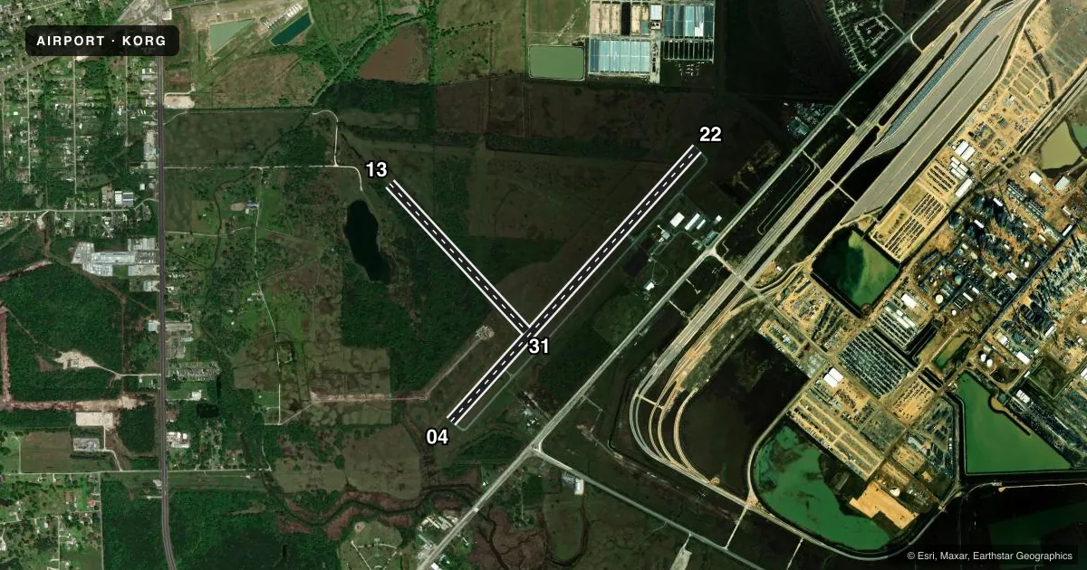
Runways & pattern
Full pagePattern entry · RWY 04
LEFT TRAFFIC| Runway | Heading (°M) | Length | Surface | Traffic |
|---|---|---|---|---|
| 04/22 | 40° / 220° | 5,500 ft | ASPH | Standard L |
| 13/31 | 135° / 315° | 3,000 ft | TURF | Standard L |
Runway end performance
| End | TORA | TODA | ASDA | LDA | VGSI | Approach lights | Obstruction |
|---|---|---|---|---|---|---|---|
| 04 | — | — | — | — | PAPI 2-box left(3°) | — | 35', trees, 425' from thr, 275' R of cntrln, slope 6 |
| 22 | — | — | — | — | PAPI 2-box left(3°) | — | 45', trees, 1000' from thr, 380' R of cntrln, slope 17 |
| 13 | — | — | — | — | — | — | 30', tree, 0' from thr, 50' R of cntrln, slope 0 |
| 31 | — | — | — | — | — | — | 60', trees, 800' from thr, 0' R of cntrln, slope 13 |
Declared distances in feet. TORA = takeoff run available, TODA = takeoff distance, ASDA = accelerate-stop, LDA = landing distance.
Airport sketch
Runways drawn to scale from FAA survey coordinates, rendered over satellite imagery. Not for navigation.
Approaches & charts
Services on the field
Fuel grades, oxygen, maintenance, ramp storage and lighting — as declared to the FAA by the airport operator.
Fuel & services
- Fuel
- 100LLA
- Airframe repair
- Not available
- Power plant repair
- Not available
Ramp & ground
- Transient storage
- Tie-down
- Landing fee
- No fee published
- Customs
- Not available
- Lighting schedule
- SEE RMK
- Beacon schedule
- SS-SR
- Beacon
- White / Green (civil land)(WG)
- Wind indicator
- Lighted
- Segmented circle
- Yes
Fuel & FBOs
Cheapest 100LL and Jet A on the field and nearby. Always confirm with the FBO before taxi.
Airport notes
Surface conditions, obstructions, local procedures, lighting outages and other notes published with each FAA cycle.
General notes
- FOR CD CTC HOUSTON APCH AT 281-443-5844 TO CNL IFR CALL 281-443-5888.
Lighting notes
- MIRL RWY 04/22 PRESET LOW INTST; TO INCR INTST & ACTVT REIL RWY 4 & 22 - CTAF.
Runway surface & condition
- 13/31RWY 13/31 CLSD PERM.
Other notes
- PREDATES ACT.
VFR map & nearby airports
VFR sectional. Tap any ICAO chip to open that airport.
Key facts · KORG
Answer card- ICAO
- KORG
- Name
- ORANGE COUNTY
- Location
- ORANGE, TEXAS
- Elevation
- 13.2 ft MSL
- Traffic pattern altitude
- 1,013.2 ft MSL (1,000 AGL)
- Control tower
- Non-towered (use CTAF)
- Total runways
- 2
- Longest runway
- 04/22 · 5,500 ft
- Published ILS approaches
- 0
- Published frequencies
- 4
- Magnetic variation
- 2°
- Current flight rules
- VFR
- Current wind
- 000° at 0 kt
- Favored runway now
- –
Orange County Airport sits in Orange, Texas. Field elevation is 13.2 ft MSL. It has two runways. The longest is 5,500 ft on runway 04/22. This is a non-towered field. CTAF and UNICOM are both 122.8. No ILS approaches are published here. Pattern altitude is not published, so use the standard 1,000 ft AGL for light piston traffic unless the current Chart Supplement says otherwise.
The on-field FBO is Orange County Airport. It carries 100LL and Jet A with Prist. Call (409) 882-7861 before you go if you need current ramp or fuel details. The published remarks matter here. Runway 13/31 is closed indefinitely. It is also listed as rough with deep ruts, so plan on using runway 04/22. Trees are noted as obstacles near the surface of runway 13/31. Runway 04/22 has medium intensity lights that default to low intensity. Use the CTAF to increase intensity and turn on the runway end identifier lights.
This is a low-elevation field, so density altitude is usually less of a factor than at higher airports. Still, check the current weather and runway condition before departure. For IFR work, Houston Approach handles clearance delivery and IFR cancel calls. If you need current operational details, verify with the airport operator or the FBO directly by phone.