METAR & TAF 45R
45R does not publish a METAR.
Showing the nearest reporting station: KBMT (BEAUMONT MUNI) · 16.1 NM away. Conditions at 45R may differ.
METAR · KBMT
Observed 11:35Z
KBMT 271135Z AUTO 00000KT 7SM SCT021 24/23 A2999 RMK AO2 T02370229
- Wind
- 000° @ 0 kt
- Visibility
- 7 SM
- Temp / Dew
- 24°C / 23°C
- Altimeter
- 29.99 inHg
- Clouds
- SCT
- Density alt
- 1,081 ft
- Ceiling
- Unlimited
- Rules
- VFR
Airport info & contacts
Manager on record, flight service, ARTCC, attendance schedule and pattern altitude — published by the FAA and refreshed every 28 days.
Location
- From city
- 3 NM SE
- VFR sectional
- HOUSTON
- ARTCC
- ZHU · HOUSTON
- NOTAM facility
- CXO (NOTAM-D)
Airport manager
- Name
- DALE WILLIFORD
- Phone
- 409-782-7620
- Address
- PO BOX 502, KOUNTZE TX 77625
Flight service · Hours
- FSS CXO
- MONTGOMERY COUNTY1-800-WX-BRIEF
- Attendance
- 0800-1730
Frequencies
Tap any row to copy the frequency to your clipboard.
Runways & pattern
Full pagePattern entry · RWY 13
LEFT TRAFFICRunway end performance
| End | TORA | TODA | ASDA | LDA | VGSI | Approach lights | Obstruction |
|---|---|---|---|---|---|---|---|
| 13 | — | — | — | — | PAPI 2-box left(3°) | — | 100', trees, 1550' from thr, 425' R of cntrln, slope 13 |
| 31 | — | — | — | — | PAPI 2-box left(4°) | — | 100', trees, 1700' from thr, 380' R of cntrln, slope 15 |
Declared distances in feet. TORA = takeoff run available, TODA = takeoff distance, ASDA = accelerate-stop, LDA = landing distance.
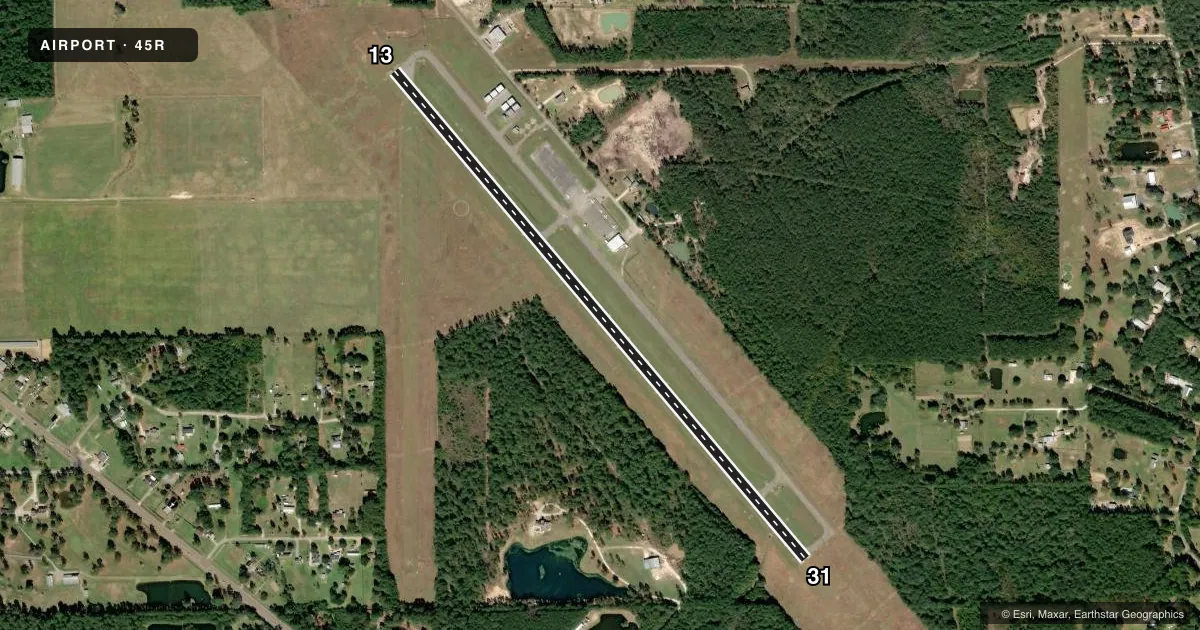
Airport sketch
Runways drawn to scale from FAA survey coordinates, rendered over satellite imagery. Not for navigation.
Approaches & charts
Services on the field
Fuel grades, oxygen, maintenance, ramp storage and lighting — as declared to the FAA by the airport operator.
Fuel & services
- Fuel
- 100LLA
- Other services
- INSTR,RNTL
Ramp & ground
- Transient storage
- Tie-down
- Landing fee
- No fee published
- Customs
- Not available
- Lighting schedule
- SEE RMK
- Beacon schedule
- SS-SR
- Beacon
- White / Green (civil land)(WG)
- Wind indicator
- Lighted
- Segmented circle
- Yes
Fuel & FBOs
Cheapest 100LL and Jet A on the field and nearby. Always confirm with the FBO before taxi.
Airport notes
Surface conditions, obstructions, local procedures, lighting outages and other notes published with each FAA cycle.
General notes
- FOR CD CTC HOUSTON APCH AT 281-443-5844 TO CNL IFR CALL 281-443-5888.
Lighting notes
- MIRL RWY 13/31 PRESET LOW INTST DUSK-DAWN; TO INCR INTST ACTVT - CTAF.
Fuel notes
- 100LL24 HR SELF SERVE FUEL.
Approach & departure obstructions
- 31PAPI OTS
VFR map & nearby airports
VFR sectional. Tap any ICAO chip to open that airport.
Key facts · 45R
Answer card- ICAO
- 45R
- Name
- HAWTHORNE FLD
- Location
- KOUNTZE/SILSBEE, TEXAS
- Elevation
- 70.8 ft MSL
- Traffic pattern altitude
- 1,070.8 ft MSL (1,000 AGL)
- Control tower
- Non-towered (use CTAF)
- Total runways
- 1
- Longest runway
- 13/31 · 4,303 ft
- Published ILS approaches
- 0
- Published frequencies
- 4
- Magnetic variation
- 4°
- Current flight rules
- VFR
- Current wind
- 000° at 0 kt
- Favored runway now
- –
HAWTHORNE FLD sits near Kountze and Silsbee in southeast Texas. Field elevation is 70.8 ft MSL. The airport has one runway, 13/31, which is 4,303 ft long and asphalt. There is no control tower. Pattern altitude is not published, so use 1,000 ft AGL for light piston traffic unless the current Chart Supplement says otherwise.
No ILS approaches are published here. Runway 31 has a PAPI that is out of service. The runway lights on 13/31 are medium intensity lights set to low from dusk to dawn. You can increase intensity by activating them on CTAF. Runway and taxiway markings on runway 13 are faded, so pay close attention on taxi and rollout.
Hardin County Aviation is on the field. It carries 100LL and Jet A. Twenty-four hour self-serve 100LL is available. CTAF and UNICOM are both 122.8. Houston Approach handles IFR on 121.3 or 377.1. For clearance delivery, contact Houston Approach directly. If you are coming in at night or in marginal weather, plan for an uncontrolled field with no published ILS and verify the current Chart Supplement before departure.