METAR & TAF KDWH
Current METAR
Observed 07:53Z
KDWH 270753Z AUTO 20003KT 9SM CLR 26/24 A2998 RMK AO2 SLP150 T02560239 $
- Wind
- 200° @ 3 kt
- Visibility
- 9 SM
- Temp / Dew
- 26°C / 24°C
- Altimeter
- 29.98 inHg
- Clouds
- CLR
- Density alt
- 1,435 ft
- Ceiling
- Unlimited
- Rules
- VFR
Airport info & contacts
Manager on record, flight service, ARTCC, attendance schedule and pattern altitude — published by the FAA and refreshed every 28 days.
Location
- From city
- 17 NM NW
- VFR sectional
- HOUSTON
- ARTCC
- ZHU · HOUSTON
- NOTAM facility
- DWH (NOTAM-D)
Airport manager
- Name
- AMY MOUNGER
- Phone
- 281-376-5436
- Address
- 20803 STEUBNER AIRLINE, NR 0, SPRING TX 77379
Flight service · Hours
- FSS CXO
- MONTGOMERY COUNTY1-800-WX-BRIEF
- Attendance
- ALL
Frequencies
Tap any row to copy the frequency to your clipboard.
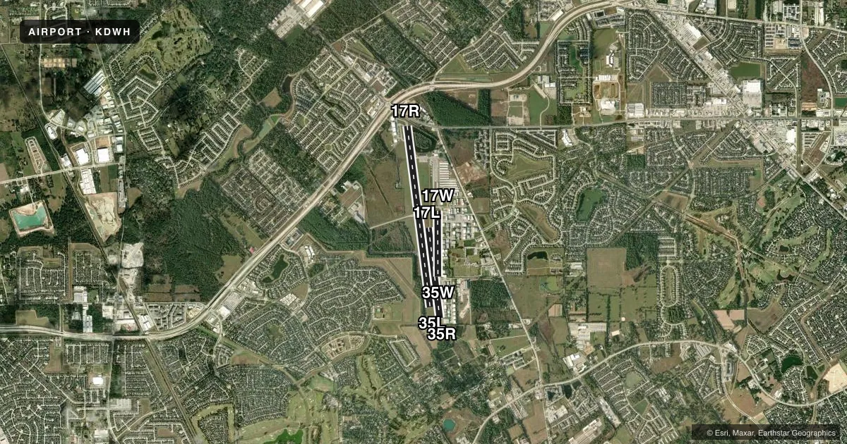
Runways & pattern
Full pagePattern entry · RWY 17W
LEFT TRAFFIC| Runway | Heading (°M) | Length | Surface | Traffic |
|---|---|---|---|---|
| 17R/35L | 168° / 348° | 7,009 ft | ASPH | Standard L |
| 17L/35R | 168° / 348° | 3,500 ft | ASPH | 35R R |
| 17W/35WFavored | 175° / 355° | 2,530 ft | WATER | 35W R |
Runway end performance
| End | TORA | TODA | ASDA | LDA | VGSI | Approach lights | Obstruction |
|---|---|---|---|---|---|---|---|
| 17R | 7,009' | 7,009' | 7,009' | 6,002' | PAPI 4-box right(3°) | — | 15', road, 200' from thr, 160' R of cntrln, slope 0 |
| 35L | 6,700' | 6,700' | 6,700' | 6,700' | PAPI 4-box left(3°) | — | 60', trees, 300' from thr, 260' R of cntrln, slope 1 |
| 35R | — | — | — | — | — | — | 60', trees, 300' from thr, 110' R of cntrln, slope 1 |
| 17W | — | — | — | — | — | — | 10', berm, 0' from thr, 0' R of cntrln, slope 0 |
| 35W | — | — | — | — | — | — | 4', berm, 0' from thr, 0' R of cntrln, slope 0 |
Declared distances in feet. TORA = takeoff run available, TODA = takeoff distance, ASDA = accelerate-stop, LDA = landing distance.
Airport sketch
Runways drawn to scale from FAA survey coordinates, rendered over satellite imagery. Not for navigation.
Approaches & charts
ILS · 1
Services on the field
Fuel grades, oxygen, maintenance, ramp storage and lighting — as declared to the FAA by the airport operator.
Fuel & services
- Fuel
- 100LLA1+
- Oxygen (bulk)
- Low pressure
- Airframe repair
- Major
- Power plant repair
- Major
- Other services
- AVNCS,CHTR,INSTR,RNTL
Ramp & ground
- Transient storage
- Tie-down
- Hangar
- Landing fee
- No fee published
- Customs
- Not available
- Lighting schedule
- SEE RMK
- Beacon schedule
- SS-SR
- Beacon
- White / Green (civil land)(WG)
- Wind indicator
- Lighted
- Segmented circle
- Yes
Fuel & FBOs
Cheapest 100LL and Jet A on the field and nearby. Always confirm with the FBO before taxi.
Airport notes
Surface conditions, obstructions, local procedures, lighting outages and other notes published with each FAA cycle.
General notes
- TWYS UNLGTD.
- AFT SS LRG ACFT USE TWY P BTN TWYS E & C.
- HEL PRACTICE AREA WEST OF ATCT AT OR BLW 600 FT.
- FOUR HEL PRKG PADS LCTD EAST OF TWY K.
- TWY K RSTRD TO PISTON ACFT ONLY.
- TWYS A & B CLSD EAST OF RWY 17R.
- NOISE SENSITIVE AREA SW OF ARPT. ALL MIL ACFT DEPARTING RWY 17R CLIMB RWY HDG TO 650 FT MSL PRIOR TO TURNS OR REJOIN.
- ACFT 25000 LBS & OVR ARE RSTRD TO TWYS C, P, E (BTN TWYS P & G), TWY G (NORTH OF TWY E), RAMPS A AND C AND THE TOMBALL JET CNTR RAMP. ALL OTHER TWYS RSTRD TO ACFT BLW 25000 LBS.
- TWYS D & K RSTRD TO ACFT 12500 LBS AND BLW.
- INT WHERE TWYS PAPA, ECHO, JULIETTE & KILO MEET IS REFERRED TO AS THE TRIANGLE.
- FOR CD WHEN ATCT CLSD, CTC HOUSTON APCH ON CD FREQ OR CALL 281-443-5844. FOR IFR CANCELLATION WHEN ATCT CLSD, CALL 281-443-5888.
- WILDLIFE ON & INVOF ARPT.
- RAPID RFL AVBL HEL DURG FBO HRS, PPR 24 HRS. CTC OPNS MGR 832-953-8572 OR FREQ 122.95 PRIOR TO LNDG.
Lighting notes
- WHEN ATCT CLSD ACTVT REIL RWYS 17R & 35L; HIRL RWY 17R/35L - CTAF.
Approach & departure obstructions
- 17R8 FT FENCE, 0 FT DSTC, 240 L, 15 FT RD, 145 FT DSTC, 238 FT L.
- 17RREIL LCTD 126 FT BYD DSPLCD THR.
- 17WBUOY
- 35WBUOY
- 17RAPCH RATIO 26:1 AT DSPLCD THR OVR 100 FT TREES 2600 FT DSTC.
- 35ROBSTN CLNC SLOPE 7:1 AT DSPLCD THLD.
- 17WALSO 25 FT HGRS, 185 FT DSTC, 135 FT L, 7:1.
Other notes
- THIS AIRPORT HAS BEEN SURVEYED BY THE NATIONAL GEODETIC SURVEY.
- OWNERNORTHWEST ARPT MANAGEMENT, L.P.
- MANAGERRSCHMIDT@HOOKSAIRPORT.COM
VFR map & nearby airports
VFR sectional. Tap any ICAO chip to open that airport.
Key facts · KDWH
Answer card- ICAO
- KDWH
- Name
- DAVID WAYNE HOOKS MEML
- Location
- HOUSTON, TEXAS
- Elevation
- 152.4 ft MSL
- Traffic pattern altitude
- 1,152.4 ft MSL (1,000 AGL)
- Control tower
- Towered · 0700-2200
- Total runways
- 3
- Longest runway
- 17R/35L · 7,009 ft
- Published ILS approaches
- 1
- Published frequencies
- 11
- Magnetic variation
- 5°
- Current flight rules
- VFR
- Current wind
- 200° at 3 kt
- Favored runway now
- RWY 17W
David Wayne Hooks Meml Airport is in Houston, Texas. Field elevation is 152.4 ft MSL. It has three runways. The longest is 7,009 ft on 17R/35L. The airport is towered from 0700 to 2200. One ILS is published for runway 17R. Pattern altitude is not published, so use the standard 1,000 ft AGL for light piston traffic unless ATC or the current Chart Supplement says otherwise.
Gill Aviation is on the field. It carries 100LL and Jet A Prist. Call them at (281) 376-5436 for current service details. The airport also has published notes that matter for planning. There is a noise sensitive area southwest of the field. Large aircraft have taxi restrictions, so verify taxi routing if you are operating a heavier airplane. Taxiways are unlighted. Birds and deer are reported in and around the airport.
Runway 17R has published obstruction notes near the threshold. There is also a displaced-threshold note on 35R with trees near the approach path. If you are planning a night arrival or a heavier arrival, review the current Chart Supplement and brief the airport carefully before you go. The field sits in a busy Houston environment, so expect normal towered-airport sequencing and keep the local procedures in mind.