METAR & TAF KSGR
Current METAR
Observed 09:53Z
KSGR 270953Z AUTO 00000KT 10SM CLR 24/24 A2997 RMK AO2 SLP150 T02440244 $
- Wind
- 000° @ 0 kt
- Visibility
- 10 SM
- Temp / Dew
- 24°C / 24°C
- Altimeter
- 29.97 inHg
- Clouds
- CLR
- Density alt
- 1,119 ft
- Ceiling
- Unlimited
- Rules
- VFR
Airport info & contacts
Manager on record, flight service, ARTCC, attendance schedule and pattern altitude — published by the FAA and refreshed every 28 days.
Location
- From city
- 17 NM SW
- VFR sectional
- HOUSTON
- ARTCC
- ZHU · HOUSTON
- NOTAM facility
- SGR (NOTAM-D)
Airport manager
- Name
- MITCHELL T. DAVIES
- Phone
- 281-275-2100
- Address
- 12888 B HWY 6 SOUTH, SUGAR LAND TX 77498
Flight service · Hours
- FSS CXO
- MONTGOMERY COUNTY1-800-WX-BRIEF
- Attendance
- 0500-2300
Frequencies
Tap any row to copy the frequency to your clipboard.
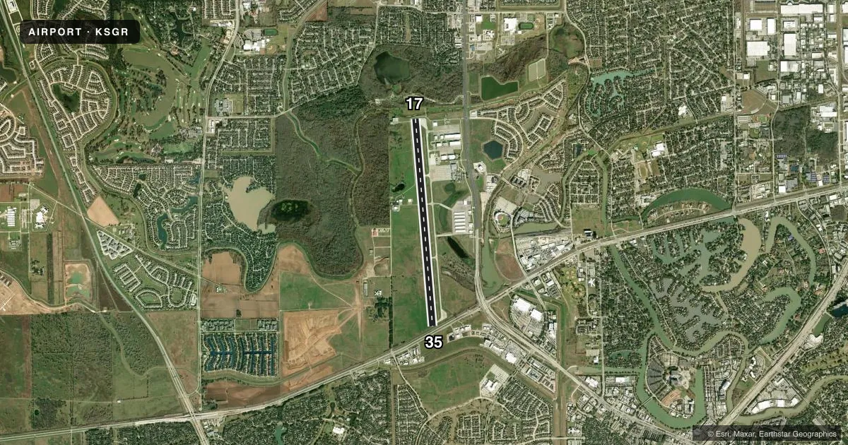
Runways & pattern
Full pagePattern entry · RWY 17
LEFT TRAFFICRunway end performance
| End | TORA | TODA | ASDA | LDA | VGSI | Approach lights | Obstruction |
|---|---|---|---|---|---|---|---|
| 17 | — | — | — | — | PAPI 2-box right(3.5°) | — | 56', trees, 500' from thr, 360' R of cntrln, slope 5 |
| 35 | — | — | — | — | PAPI 4-box left(3°) | — | 30', pline, 201' from thr, 200' R of cntrln, slope 0 |
Declared distances in feet. TORA = takeoff run available, TODA = takeoff distance, ASDA = accelerate-stop, LDA = landing distance.
Airport sketch
Runways drawn to scale from FAA survey coordinates, rendered over satellite imagery. Not for navigation.
Approaches & charts
ILS · 1
Services on the field
Fuel grades, oxygen, maintenance, ramp storage and lighting — as declared to the FAA by the airport operator.
Fuel & services
- Fuel
- 100LLA+
- Oxygen (bottled)
- Not available
- Oxygen (bulk)
- HIGH/LOW
- Airframe repair
- Major
- Power plant repair
- Major
- Other services
- AMB,CHTR,INSTR,RNTL
Ramp & ground
- Transient storage
- Tie-down
- Hangar
- Landing fee
- Yes
- Customs
- Not available
- Lighting schedule
- SEE RMK
- Beacon schedule
- SS-SR
- Beacon
- White / Green (civil land)(WG)
- Wind indicator
- Lighted
- Segmented circle
- Yes
Fuel & FBOs
Cheapest 100LL and Jet A on the field and nearby. Always confirm with the FBO before taxi.
Airport notes
Surface conditions, obstructions, local procedures, lighting outages and other notes published with each FAA cycle.
General notes
- NO TGLS AFT TWR CLOSES.
- MIL AND CORPORATE GND TRANSPORTATION PRVDD.
- BIRDS ON & INVOF ARPT.
- NOISE ABATEMENT PROC: NOISE SENSITIVE AREAS - INFO AVBL AT TRML.
- NO INT DEPS FOR MULTI-ENGINE ACFT.
- FOR CD WHEN ATCT IS CLSD CTC HOUSTON APCH AT 281-443-5844 TO CNL IFR AT 281-443-5888.
- SFC CONDS NOT RPRTD 10:00 PM - 6:00 AM DLY.
- LRA M-F 0800-1200 & 1300-1700. OTR TIMES BY APPT.
Lighting notes
- WHEN ATCT CLSD ACTVT REIL RWY 17 & 35; HIRL RWY 17/35 - CTAF.
Fuel notes
- 100LL100LL AVBL 24 HRS SELF SERVE. FOR JET A+ AFT HRS CALL 281-275-2400 DURG ATNDD HRS.
Approach & departure obstructions
- 1710 FT RD 0-57 FT DSTC; 50 FT TREES, 0-100 FT DSTC, 488 FT L.
- 3527 FT RR 90 FT DSTC ON CNTRLN; 17 FT RD, 30 PLINE.
- 17OBSTN CLNC SLOPE 14:1 TO DSPLCD THR.
- 35OBSTN CLNC SLOPE 50:1 TO DSPLCD THLD OVR 27 FT RR TRACKS 2074 FT DSTC.
Other notes
- PRVDD THRS DSPLCD TO MAINTAIN CLEAR 20:1 APCH SLOPE OVER ALL OBSTNS AT RWY ENDS.
- NITROGEN AVBL DURG BUSINESS HRS.
- RAMP FEE FOR CIVIL ACFT; WAIVED WITH FUEL PURCHASE.
- CHTRJASU - 1(MD-3) 1(C-26) 1(MA-1A)
- 17/35RWY NOT GRVD.
VFR map & nearby airports
VFR sectional. Tap any ICAO chip to open that airport.
Key facts · KSGR
Answer card- ICAO
- KSGR
- Name
- SUGAR LAND RGNL
- Location
- HOUSTON, TEXAS
- Elevation
- 81.1 ft MSL
- Traffic pattern altitude
- 1,081.1 ft MSL (1,000 AGL)
- Control tower
- Towered · 0600-2200
- Total runways
- 1
- Longest runway
- 17/35 · 8,000 ft
- Published ILS approaches
- 1
- Published frequencies
- 10
- Magnetic variation
- 5°
- Current flight rules
- VFR
- Current wind
- 000° at 0 kt
- Favored runway now
- –
Sugar Land Rgnl sits in Houston, Texas at 81.1 ft MSL. It has one runway, 17/35, which is 8,000 ft long and paved with concrete. The tower is open daily from 0600 to 2200. One ILS approach is published for runway 35. The pattern altitude is not published in the facts, so use the standard 1,000 ft AGL for light piston traffic unless ATC or the current Chart Supplement says otherwise.
Global Select is on the field. It carries 100LL and Jet A. 100LL is available 24 hours self-serve. For Jet A after hours, call the FBO during attended hours at (281) 275-2400. The airport remarks also note birds on and near the field. That is worth keeping in mind on arrival and departure.
There are a few runway details to brief before you go. Runway 17/35 is not grooved. The published remarks also call out displaced thresholds and obstruction issues on both ends. Runway 35 has railroad tracks, trees, a road and a powerline noted near the approach path. Noise sensitive areas are published at the terminal. No touch-and-go landings are allowed after the tower closes. Surface conditions are not reported from 2200 to 0600. Check the current FAA Chart Supplement before departure for the latest runway and noise notes.