METAR & TAF KIWS
KIWS does not publish a METAR.
Showing the nearest reporting station: KTME (HOUSTON EXEC) · 11.8 NM away. Conditions at KIWS may differ.
METAR · KTME
Observed 07:35Z
KTME 270735Z AUTO 18005KT 10SM 25/25 A3000 RMK AO2
- Wind
- 180° @ 5 kt
- Visibility
- 10 SM
- Temp / Dew
- 25°C / 25°C
- Altimeter
- 30.00 inHg
- Clouds
- Clear
- Density alt
- 1,238 ft
- Ceiling
- Unlimited
- Rules
- VFR
Airport info & contacts
Manager on record, flight service, ARTCC, attendance schedule and pattern altitude — published by the FAA and refreshed every 28 days.
Location
- From city
- 13 NM W
- VFR sectional
- HOUSTON
- ARTCC
- ZHU · HOUSTON
- NOTAM facility
- CXO (NOTAM-D)
Airport manager
- Name
- WOODY LESIKAR
- Phone
- 281-492-2130
- Address
- BOX 941789, HOUSTON TX 77094-8789
Flight service · Hours
- FSS CXO
- MONTGOMERY COUNTY1-800-WX-BRIEF
- Attendance
- ALL
Frequencies
Tap any row to copy the frequency to your clipboard.
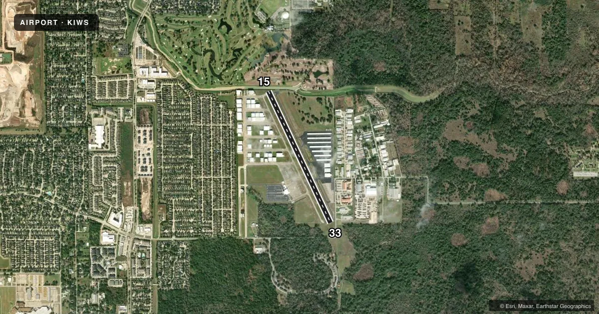
Runways & pattern
Full pagePattern entry · RWY 15
LEFT TRAFFICRunway end performance
| End | TORA | TODA | ASDA | LDA | VGSI | Approach lights | Obstruction |
|---|---|---|---|---|---|---|---|
| 15 | — | — | — | — | PAPI 2-box right(3.7°) | — | 50', trees, 600' from thr, 60' R of cntrln, slope 8 |
| 33 | — | — | — | — | PAPI 2-box left(3.7°) | — | 15', road, 200' from thr, 60' R of cntrln, slope 0 |
Declared distances in feet. TORA = takeoff run available, TODA = takeoff distance, ASDA = accelerate-stop, LDA = landing distance.
Airport sketch
Runways drawn to scale from FAA survey coordinates, rendered over satellite imagery. Not for navigation.
Approaches & charts
Services on the field
Fuel grades, oxygen, maintenance, ramp storage and lighting — as declared to the FAA by the airport operator.
Fuel & services
- Fuel
- 100LLA+
- Oxygen (bottled)
- HIGH/LOW
- Oxygen (bulk)
- HIGH/LOW
- Airframe repair
- Major
- Power plant repair
- Major
- Other services
- AVNCS,INSTR,RNTL,SALES
Ramp & ground
- Transient storage
- Tie-down
- Hangar
- Landing fee
- Yes
- Lighting schedule
- SEE RMK
- Beacon schedule
- SS-SR
- Beacon
- White / Green (civil land)(WG)
- Wind indicator
- Lighted
- Segmented circle
- Yes
Fuel & FBOs
Cheapest 100LL and Jet A on the field and nearby. Always confirm with the FBO before taxi.
Airport notes
Surface conditions, obstructions, local procedures, lighting outages and other notes published with each FAA cycle.
General notes
- 20 FT DEEP, 25 FT WIDE DITCH, 0-166 FT DSTC ACRS APCH.
- NO TGLS BTN 2200-0600.
- NO NGT HEL TRNG.
- NO MULT TRNG FLTS BY HELS.
- WX INFO AVBL ON 125.575, 281-579-9820. ASRI 129.875.
- FOR CD CTC HOUSTON APCH AT 281-443-5844. TO CNL IFR CTC HOUSTON APCH AT 281-443-5888.
Lighting notes
- DUSK-DAWN. HIRL RWY 15/33 PRESET LOW INTST; TO INCR INTST & ACTVT REIL RWYS 15 & 33 - CTAF.
Approach & departure obstructions
- 3315 FT ROAD 150 FT EAST OF THR.
- 15NSTD NPI MARKINGS DUE TO RWY LEN. NO AIMING POINT.
- 33NSTD NPI MARKINGS DUE TO RWY LEN. NO AIMING POINT.
Other notes
- FACILITY FEE CHARGED TO NON-PATRONS, WAIVED WITH MINIMUM PURCHASE.
VFR map & nearby airports
VFR sectional. Tap any ICAO chip to open that airport.
Key facts · KIWS
Answer card- ICAO
- KIWS
- Name
- WEST HOUSTON
- Location
- HOUSTON, TEXAS
- Elevation
- 111 ft MSL
- Traffic pattern altitude
- 1,111 ft MSL (1,000 AGL)
- Control tower
- Non-towered (use CTAF)
- Total runways
- 1
- Longest runway
- 15/33 · 3,953 ft
- Published ILS approaches
- 0
- Published frequencies
- 5
- Magnetic variation
- 5°
- Current flight rules
- VFR
- Current wind
- 180° at 5 kt
- Favored runway now
- RWY 15
West Houston Airport (KIWS) sits in Houston, Texas at 111 ft MSL. It has one asphalt runway, 15/33, at 3,953 ft. There is no control tower. Pattern altitude is not published, so use the standard 1,000 ft AGL for light piston traffic unless ATC or the current Chart Supplement says otherwise. No ILS approaches are published here.
The on-field FBO is West Houston Airport. It carries 100LL and Jet A. Call the FBO directly at (281) 492-2130 for current service details before you go. Published remarks matter here. Runway 15/33 has high intensity lights that sit at low intensity from dusk to dawn. Use CTAF to bring the lights up and to activate the runway end identifier lights. Runway 33 has a road 150 ft east of the threshold. There is also a ditch that runs across part of the approach area.
This is a non-towered field in the Houston area. Expect to work the CTAF and monitor Houston Approach when needed. The published remarks also say no touch-and-go landings are allowed between 2200 and 0600. Helicopter training is restricted too. Check the current FAA Chart Supplement for any other local procedures before you fly in.