METAR & TAF KIAH
Current METAR
Observed 09:53Z
KIAH 270953Z 20004KT 10SM FEW020 FEW180 SCT250 27/24 A2997 RMK AO2 SLP148 T02670244
- Wind
- 200° @ 4 kt
- Visibility
- 10 SM
- Temp / Dew
- 27°C / 24°C
- Altimeter
- 29.97 inHg
- Clouds
- SCT
- Density alt
- 1,497 ft
- Ceiling
- Unlimited
- Rules
- VFR
Airport info & contacts
Manager on record, flight service, ARTCC, attendance schedule and pattern altitude — published by the FAA and refreshed every 28 days.
Location
- From city
- 15 NM N
- VFR sectional
- HOUSTON
- ARTCC
- ZHU · HOUSTON
- NOTAM facility
- IAH (NOTAM-D)
Airport manager
- Name
- CLIFF PRICE
- Phone
- 281-233-1131
- Address
- PO BOX 60106, HOUSTON TX 77205
Flight service · Hours
- FSS CXO
- MONTGOMERY COUNTY1-800-WX-BRIEF
- Attendance
- ALL
Frequencies
Tap any row to copy the frequency to your clipboard.
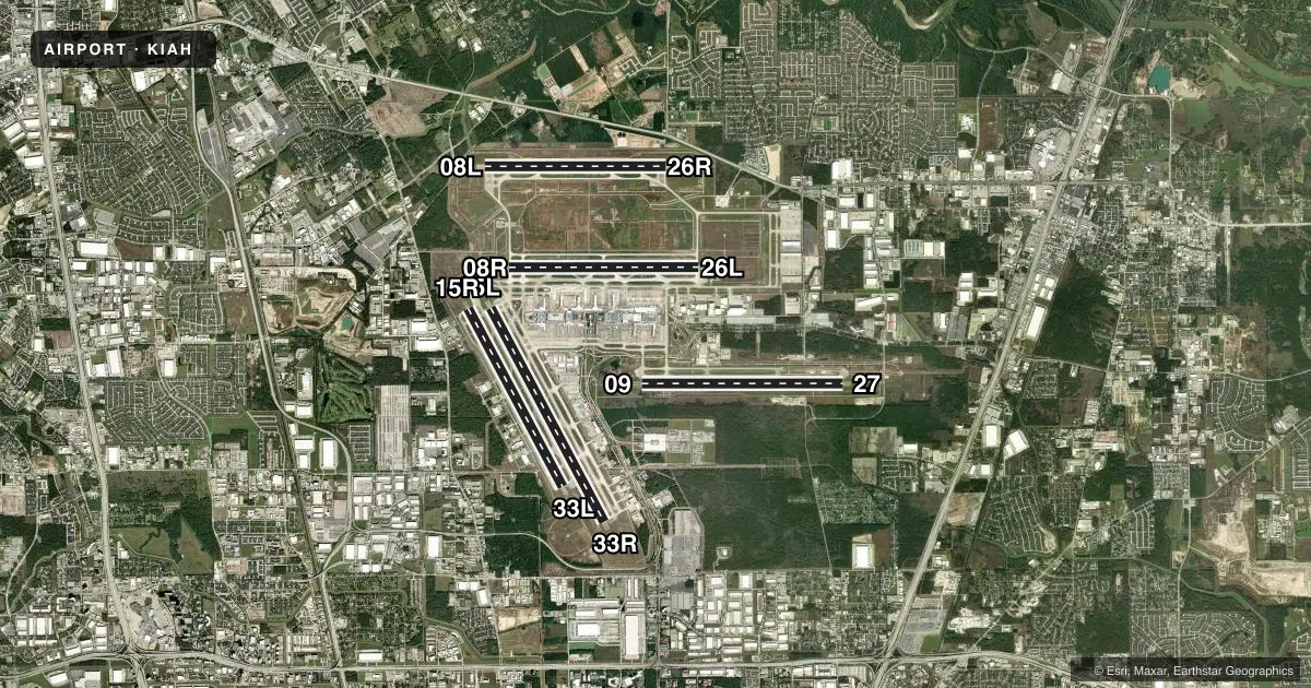
Runways & pattern
Full pagePattern entry · RWY 15L
LEFT TRAFFIC| Runway | Heading (°M) | Length | Surface | Traffic |
|---|---|---|---|---|
| 15L/33RFavored | 149° / 329° | 12,001 ft | CONC | Standard L |
| 09/27 | 87° / 267° | 10,000 ft | CONC | Standard L |
| 15R/33L | 149° / 329° | 10,000 ft | CONC | Standard L |
| 08R/26L | 87° / 267° | 9,402 ft | CONC | Standard L |
| 08L/26R | 87° / 267° | 9,000 ft | CONC | Standard L |
Runway end performance
| End | TORA | TODA | ASDA | LDA | VGSI | Approach lights | Obstruction |
|---|---|---|---|---|---|---|---|
| 15L | 12,001' | 12,001' | 12,001' | 12,001' | PAPI 4-box right(3°) | — | — |
| 33R | 12,001' | 12,001' | 12,001' | 12,001' | — | MALSR | — |
| 09 | 10,000' | 10,000' | 10,000' | 10,000' | PAPI 4-box right(3°) | MALSR | — |
| 27 | 10,000' | 10,000' | 10,000' | 10,000' | PAPI 4-box left(3°) | ALSF2 | — |
| 15R | 10,000' | 10,000' | 10,000' | 10,000' | PAPI 4-box left(3°) | MALSR | — |
| 33L | 10,000' | 10,000' | 10,000' | 10,000' | PAPI 4-box right(3°) | — | — |
| 08R | 9,402' | 9,402' | 9,402' | 9,402' | PAPI 4-box left(3°) | MALSR | — |
| 26L | 9,402' | 9,402' | 9,402' | 9,402' | PAPI 4-box right(3°) | ALSF2 | — |
| 08L | 9,000' | 9,000' | 9,000' | 9,000' | — | ALSF2 | — |
| 26R | 9,000' | 9,000' | 9,000' | 9,000' | — | ALSF2 | — |
Declared distances in feet. TORA = takeoff run available, TODA = takeoff distance, ASDA = accelerate-stop, LDA = landing distance.
Airport sketch
Runways drawn to scale from FAA survey coordinates, rendered over satellite imagery. Not for navigation.
Approaches & charts
ILS · 8
Services on the field
Fuel grades, oxygen, maintenance, ramp storage and lighting — as declared to the FAA by the airport operator.
Fuel & services
- Fuel
- 100LLA
- Oxygen (bottled)
- Not available
- Oxygen (bulk)
- Low pressure
- Airframe repair
- Major
- Power plant repair
- Major
- Other services
- AFRT,AVNCS,CARGO
Ramp & ground
- Transient storage
- Tie-down
- Hangar
- Customs
- Not available
- Lighting schedule
- SS-SR
- Beacon schedule
- SS-SR
- Beacon
- White / Green (civil land)(WG)
- Wind indicator
- Lighted
- Segmented circle
- No
Fuel & FBOs
Cheapest 100LL and Jet A on the field and nearby. Always confirm with the FBO before taxi.
Airport notes
Surface conditions, obstructions, local procedures, lighting outages and other notes published with each FAA cycle.
General notes
- DUAL TWY OPNS TWY NJ BTN TWY NB & TERMINAL C RAMP; WEST CNTRLN RSTRD TO ACFT MAX WING SPANS 118 FT & EAST CNTRLN MAX WING SPANS 118 FT.
- PILOTS CONDUCTING EFVS OPS; BE AWARE LED ALS IN USE RWY 09 & 33R.
- TWY RC CLSD TO ACFT WITH WINGSPAN GTR THAN 118 FT.
- BIRDS ON & INVOF ARPT.
- TXLN 'RA', 'RB', 'RC', 'R2', AND TWY 'SC' NORTH OF TWY 'SB' ARE DSGND NON-MOVEMENT AREAS OPERD BY UAL RAMP CTL.
- 9 FT AGL UNMKD SECURITY FENCE ADJ TO FBO & CORPORATE BASE OPR RAMPS AND NONMOV AREA TXLS.
- TWY 'NR' CLSD TO ACFT WITH WING SPANS GREATER THAN 125 FT BTN TWY 'WD' & TWY 'WB'.
- TWY 'SF' BTN TWY 'NB' AND TXL 'RA' IS DSGND NON-MOV AREA.
- DUAL TWY OPNS TWY NK BTN TWY NB & NORTH RAMP; WEST CNTRLN RSTRD TO ACFT MAX WING SPANS 125 FT & EAST CNTRLN MAX WING SPANS 214 FT.
- THE FLWG MOV AREAS ARE NOT VSB FM THE ATCT: PORTIONS OF TWYS 'WA' & 'WB' FM TWY 'WH' TO THE AER 33R; TWYS 'WA' & 'WB' FM TWY 'WD' NORTH FOR 400 FT; TWY 'WD' FM TWY 'WA' TO TWY 'NR'; TWY 'NR'; TWY 'WL' FM RWY 15L TO TWY 'WB' & TWY 'WM'.
- RWY 15L/33R MAGNETIC ANOMALIES MAY AFFECT COMPASS HDG FOR TKOF.
- TWYS WA & WB MAGNETIC ANOMALIES MAY AFFECT COMPASS HDG.
- APRON TERMINAL ALPHA NORTH RAMP NORTH-SOUTH TXL CLSD TO ACFT WINGSPAN MORE THAN 125 FT.
- TWY WC WEST OF RWY 15R/33L RSTRD TO ACFT WITH 118 FT WING SPAN AND BLW.
- NOISE SENSITIVE AREA N, E AND W OF ARPT.
- RWY STATUS LGTS ARE IN OPN.
- TWY WW RUN UP PAD FOR RWY 15L CLSD TO ACFT WITH WINGSPAN 135 FT & OVER.
- RWY 09/27 CLSD TO ACFT WITH WINGSPAN 215 FT & ABOVE.
- TWY SF BTN RWY 09/27 UP TO AND INCLUDING THE EAST BRIDGE CLSD TO ACFT WITH WINGSPAN 215 FT & OVER.
- TWY NR BTN TWY NC AND TWY WW CLSD TO ACFT WINGSPAN MORE THAN 214 FT.
- TWY WW BTN TWY NR AND TWY WB CLSD TO ACFT WINGSPAN MORE THAN 214 FT.
- TWY NR BTN WW AND TWY WB DSGND NON-MOVEMENT AREA.
- TWY NK BTN TWY NB AND TERMINAL D RAMP SIMULTANEOUS ACFT OPS PROHIBITED WHEN MIDDLE TAXILANE IN USE.
- HEL HOVER/TAXI RSTRD TO HARD SFC MOV AREAS ONLY.
- GBAS APCH SVC VOL 20NM FR THR, ALL GLS APCHS.
- TWY NA LGT ALL BTN TWY WP AND TWY NP NOT STD
- PILOTS & CREWS SHOULD BE AWARE OF DEP TURNS ON CRS IN EXCESS OF 180 DEGS. PILOT READ BACK OF DRCTN OF TURN IS HIGHLY ENCOURAGED.
- WILDLIFE HAZ BATS INVOF IAH.
- APRON TERMINAL ALPHA NORTH RAMP SPOT 5 CLSD TO ACFT WINGSPAN MORE THAN 118 FT.
- APRON TERMINAL ALPHA NORTH RAMP EAST-WEST TXL CLSD TO ACFT WINGSPAN MORE THAN 118 FT.
- APRON TERMINAL ALPHA NORTH RAMP SPOT 6 CLSD TO ACFT WINGSPAN MORE THAN 125 FT.
- TWY WD BTN TWY NR AND TWY WB CLSD TO ACFT WINGSPAN MORE THAN 171 FT.
- TWY NJ BTN TWY NB AND TERMINAL C RAMP SIMULTANEOUS ACFT OPS PROHIBITED WHEN MIDDLE TAXILANE IN USE, MIDDLE TAXILANE CLSD TO ACFT WINGSPAN MORE THAN 214FT.
Runway surface & condition
- 08R/26LPCR VALUE: 1090/R/A/W/T
- 15L/33RPCR VALUE: 870/R/B/W/T
- 15R/33LPCR VALUE: 980/R/A/W/T
- 08L/26RPCR VALUE: 1100/R/A/W/T
- 09/27PCR VALUE: 690/R/A/W/T
Other notes
- OWNERDEPT OF AVIATION, ADMIN OFFICE.
VFR map & nearby airports
VFR sectional. Tap any ICAO chip to open that airport.
Key facts · KIAH
Answer card- ICAO
- KIAH
- Name
- GEORGE BUSH INTCNTL/HOUSTON
- Location
- HOUSTON, TEXAS
- Elevation
- 95.8 ft MSL
- Traffic pattern altitude
- 1,095.8 ft MSL (1,000 AGL)
- Control tower
- Towered · 24
- Total runways
- 5
- Longest runway
- 15L/33R · 12,001 ft
- Published ILS approaches
- 8
- Published frequencies
- 24
- Magnetic variation
- 3°
- Current flight rules
- VFR
- Current wind
- 200° at 4 kt
- Favored runway now
- RWY 15L
George Bush Intcntl/Houston is in Houston, Texas. The field elevation is 95.8 ft MSL. KIAH has 5 runways. The longest is 15L/33R at 12,001 ft. The tower is open 24 hours. Eight ILS approaches are published here, with runway ends including 08L, 08R, 09, 15R, 26L, 26R, 27 and 33R. Pattern altitude is not published in the facts, so use 1,000 ft AGL for light piston unless the current Chart Supplement says otherwise.
This is a busy Class B airport, so plan for close sequencing and standard big-airport radio work. Atlantic Aviation and Signature Aviation are on the field. Both carry 100LL and Jet A. The airport remarks also flag wildlife activity, including bats and birds in the area. That matters on departure. It matters on arrival and taxi. A few taxiways and ramp areas have wingspan limits or closures, so larger aircraft should check the current Chart Supplement and coordinate with the airport operator or FBO before arrival. Runway 15L/33R also has published magnetic anomaly notes, so be ready for an unusual compass picture on takeoff. If you are new to KIAH, brief the taxi carefully and expect ramp control procedures in some areas.