METAR & TAF KELA
Current METAR
Observed 07:15Z
KELA 270715Z AUTO 19003KT 10SM CLR 25/24 A2999 RMK AO2 T02450242
- Wind
- 190° @ 3 kt
- Visibility
- 10 SM
- Temp / Dew
- 25°C / 24°C
- Altimeter
- 29.99 inHg
- Clouds
- CLR
- Density alt
- 1,341 ft
- Ceiling
- Unlimited
- Rules
- VFR
Airport info & contacts
Manager on record, flight service, ARTCC, attendance schedule and pattern altitude — published by the FAA and refreshed every 28 days.
Location
- From city
- 1 NM NE
- VFR sectional
- HOUSTON
- ARTCC
- ZHU · HOUSTON
- NOTAM facility
- ELA (NOTAM-D)
Airport manager
- Name
- CHARLES "TINK" JACKSON
- Phone
- 979-234-2640
- Address
- 100 E MAIN, PO BOX 38, EAGLE LAKE TX 77434
Flight service · Hours
- FSS CXO
- MONTGOMERY COUNTY1-800-WX-BRIEF
- Attendance
- IREG
Frequencies
Tap any row to copy the frequency to your clipboard.
Runways & pattern
Full pagePattern entry · RWY 17
LEFT TRAFFICRunway end performance
| End | TORA | TODA | ASDA | LDA | VGSI | Approach lights | Obstruction |
|---|---|---|---|---|---|---|---|
| 17 | — | — | — | — | PAPI 2-box left(3°) | — | — |
| 35 | — | — | — | — | PAPI 2-box left(3°) | — | — |
Declared distances in feet. TORA = takeoff run available, TODA = takeoff distance, ASDA = accelerate-stop, LDA = landing distance.
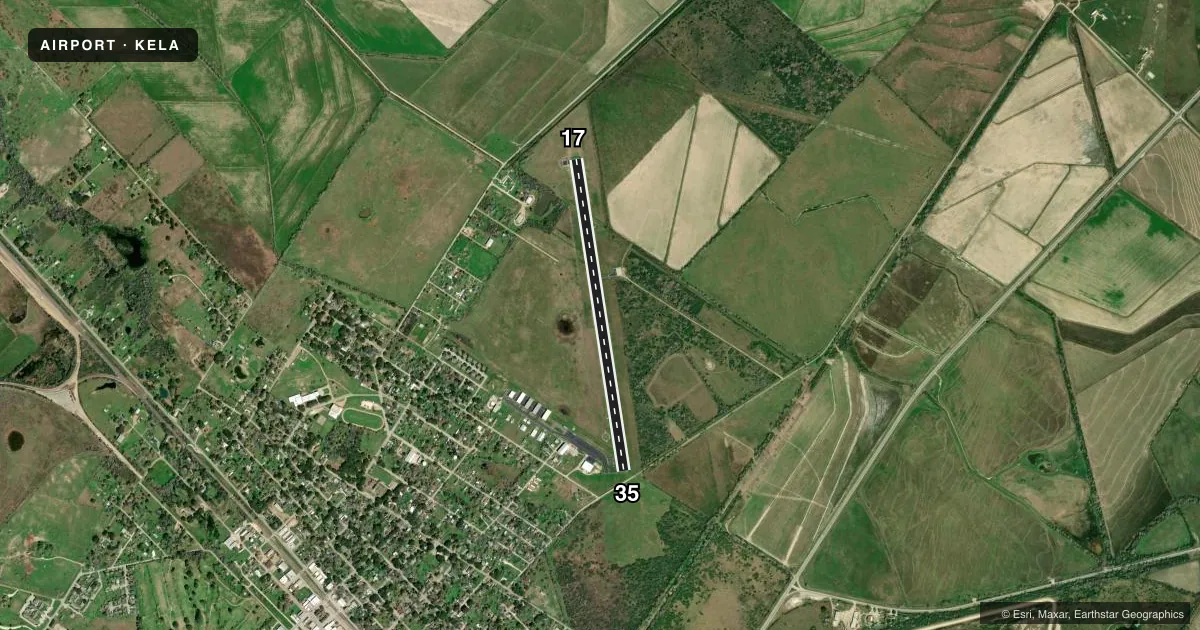
Airport sketch
Runways drawn to scale from FAA survey coordinates, rendered over satellite imagery. Not for navigation.
Approaches & charts
Services on the field
Fuel grades, oxygen, maintenance, ramp storage and lighting — as declared to the FAA by the airport operator.
Fuel & services
- Fuel
- 100LLA
- Oxygen (bottled)
- Not available
- Oxygen (bulk)
- Not available
- Other services
- AGRI,INSTR
Ramp & ground
- Transient storage
- Tie-down
- Landing fee
- No fee published
- Customs
- Not available
- Lighting schedule
- SEE RMK
- Beacon schedule
- SS-SR
- Beacon
- White / Green (civil land)(WG)
- Wind indicator
- Lighted
- Segmented circle
- Yes
Fuel & FBOs
Cheapest 100LL and Jet A on the field and nearby. Always confirm with the FBO before taxi.
Airport notes
Surface conditions, obstructions, local procedures, lighting outages and other notes published with each FAA cycle.
General notes
- FOR CD CTC HOUSTON APCH AT 281-443-5844 TO CNL IFR CALL 281-443-5888.
Lighting notes
- MIRL RWY 17/35 PRESET LOW; TO INCR INTST ACTVT - CTAF.
Other notes
- PREDATES ACT.
- 1FOR SVC AFT HRS CALL 713-502-4064
- MANAGERCITY / ARPT MGR.
VFR map & nearby airports
VFR sectional. Tap any ICAO chip to open that airport.
Key facts · KELA
Answer card- ICAO
- KELA
- Name
- EAGLE LAKE
- Location
- EAGLE LAKE, TEXAS
- Elevation
- 184.1 ft MSL
- Traffic pattern altitude
- 1,184.1 ft MSL (1,000 AGL)
- Control tower
- Non-towered (use CTAF)
- Total runways
- 1
- Longest runway
- 17/35 · 4,280 ft
- Published ILS approaches
- 0
- Published frequencies
- 3
- Magnetic variation
- 5°
- Current flight rules
- VFR
- Current wind
- 190° at 3 kt
- Favored runway now
- RWY 17
Eagle Lake Airport sits in Eagle Lake, Texas. Field elevation is 184.1 ft MSL. The airport has one runway. Runway 17/35 is 4,280 ft asphalt, with magnetic headings of 171° and 351°. There is no control tower. No ILS approaches are published.
Pattern altitude is not published. Use 1,000 ft AGL for light piston operations unless the current Chart Supplement says otherwise. The field uses CTAF 122.9. Houston Approach handles IFR services on 124.225 and 306.975. For clearance delivery, use Houston Approach at 281-443-5844. To cancel IFR, call 281-443-5888.
Eagle Lake Aviation is on the field. It carries 100LL and Jet A. Call (713) 502-4064 for current service or after-hours needs. The runway lights on 17/35 are medium intensity lights that default to low. Use the CTAF to step them up. There is also a published obstruction note near runway 35. A road sits off the right side of the runway environment. Keep that in mind on the departure end. This is a small, non-towered field with simple pavement. Plan your arrival. Self-announce clearly. Verify any current airport or operational notes before you go.