METAR & TAF 94R
94R does not publish a METAR.
Showing the nearest reporting station: KARM (WHARTON RGNL) · 7.7 NM away. Conditions at 94R may differ.
METAR · KARM
Observed 01:15Z
KARM 270115Z AUTO 17007KT 10SM CLR 29/23 A2998 RMK AO2 T02910225 TSNO
- Wind
- 170° @ 7 kt
- Visibility
- 10 SM
- Temp / Dew
- 29°C / 23°C
- Altimeter
- 29.98 inHg
- Clouds
- CLR
- Density alt
- 1,717 ft
- Ceiling
- Unlimited
- Rules
- VFR
Airport info & contacts
Manager on record, flight service, ARTCC, attendance schedule and pattern altitude — published by the FAA and refreshed every 28 days.
Location
- From city
- 5 NM SE
- VFR sectional
- HOUSTON
- ARTCC
- ZHU · HOUSTON
- NOTAM facility
- CXO (NOTAM-D)
Airport manager
- Name
- WILLIAM GAVRANOVIC, JR
- Phone
- 979-533-1531
- Address
- 5713 CR 156 RC, WHARTON TX 78488
Flight service · Hours
- FSS CXO
- MONTGOMERY COUNTY1-800-WX-BRIEF
- Attendance
- Unattended
Frequencies
Tap any row to copy the frequency to your clipboard.
Runways & pattern
Full pagePattern entry · RWY 15
RIGHT TRAFFICRunway end performance
| End | TORA | TODA | ASDA | LDA | VGSI | Approach lights | Obstruction |
|---|---|---|---|---|---|---|---|
| 33 | — | — | — | — | — | — | 45', tree, 900' from thr, 60' R of cntrln, slope 15 |
Declared distances in feet. TORA = takeoff run available, TODA = takeoff distance, ASDA = accelerate-stop, LDA = landing distance.
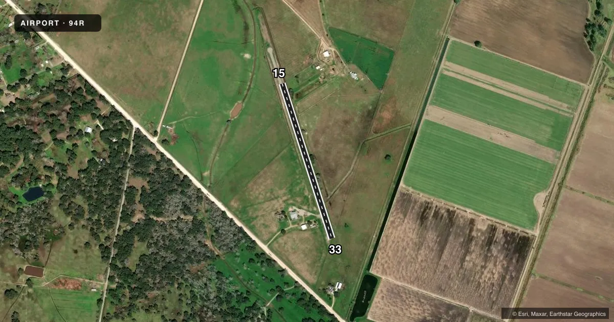
Airport sketch
Runways drawn to scale from FAA survey coordinates, rendered over satellite imagery. Not for navigation.
Approaches & charts
Services on the field
Fuel grades, oxygen, maintenance, ramp storage and lighting — as declared to the FAA by the airport operator.
Fuel & services
- Fuel
- Not available
Ramp & ground
- Transient storage
- Not published
- Landing fee
- No fee published
- Wind indicator
- Lighted
- Segmented circle
- No
Fuel & FBOs
Cheapest 100LL and Jet A on the field and nearby. Always confirm with the FBO before taxi.
Airport notes
Surface conditions, obstructions, local procedures, lighting outages and other notes published with each FAA cycle.
General notes
- ARPT CLSD 1 HR BFR SS TIL 1 HR AFT SR DLY.
- FOR CD CTC HOUSTON ARTCC AT 281-230-5622.
- ARPT PHYS ADDR 7707 FM 3012 RD.
Approach & departure obstructions
- 1515 FT TREE, 0 FT DSTC, 80 FT R.
- 334 FT FENCE ACRS RWY THR.
- 15RWY 15/33 NO MKGS.
VFR map & nearby airports
VFR sectional. Tap any ICAO chip to open that airport.
Key facts · 94R
Answer card- ICAO
- 94R
- Name
- GAV AIR
- Location
- WHARTON, TEXAS
- Elevation
- 90 ft MSL
- Traffic pattern altitude
- 1,090 ft MSL (1,000 AGL)
- Control tower
- Non-towered (use CTAF)
- Total runways
- 1
- Longest runway
- 15/33 · 2,167 ft
- Published ILS approaches
- 0
- Published frequencies
- 1
- Magnetic variation
- 6°
- Current flight rules
- VFR
- Current wind
- 170° at 7 kt
- Favored runway now
- RWY 15
GAV AIR (94R) sits in Wharton, Texas. Field elevation is 90 ft MSL. The airport has one runway. Runway 15/33 is 2,167 ft long with an asphalt-dirt surface. The runway headings are 162° and 342° magnetic. No tower is published here. CTAF is 122.9.
No ILS approaches are published. Pattern altitude is not published, so use the standard 1,000 ft AGL for light piston traffic unless the current Chart Supplement says otherwise. That puts the traffic pattern at 1,090 ft MSL based on the listed field elevation. There are no on-field FBOs listed, so plan ahead for services before you go.
The published remarks matter here. A 4 ft fence crosses the runway 33 threshold. A 15 ft tree sits near the runway 15 side. The airport is closed one hour before sunset until one hour after sunrise each day. For clearance delivery, Houston ARTCC is listed at 281-230-5622. This is a small field with a short runway. Check performance carefully, especially if you are operating a heavier aircraft or dealing with a tailwind component.