METAR & TAF 66R
Current METAR
Observed 20:55Z
K66R 242055Z AUTO 19007KT 10SM SCT044 SCT060 BKN065 33/24 A3002 RMK AO2 T03320236
- Wind
- 190° @ 7 kt
- Visibility
- 10 SM
- Temp / Dew
- 33°C / 24°C
- Altimeter
- 30.02 inHg
- Clouds
- BKN
- Density alt
- 2,336 ft
- Ceiling
- 6,500 ft AGL
- Rules
- VFR
Airport info & contacts
Manager on record, flight service, ARTCC, attendance schedule and pattern altitude — published by the FAA and refreshed every 28 days.
Location
- From city
- 3 NM S
- VFR sectional
- HOUSTON
- ARTCC
- ZHU · HOUSTON
- NOTAM facility
- CXO (NOTAM-D)
Airport manager
- Name
- TY PRAUSE
- Phone
- 979-732-2604
- Address
- 400 SPRING ST., COLUMBUS TX 78934
Flight service · Hours
- FSS CXO
- MONTGOMERY COUNTY1-800-WX-BRIEF
- Attendance
- Unattended
Frequencies
Tap any row to copy the frequency to your clipboard.
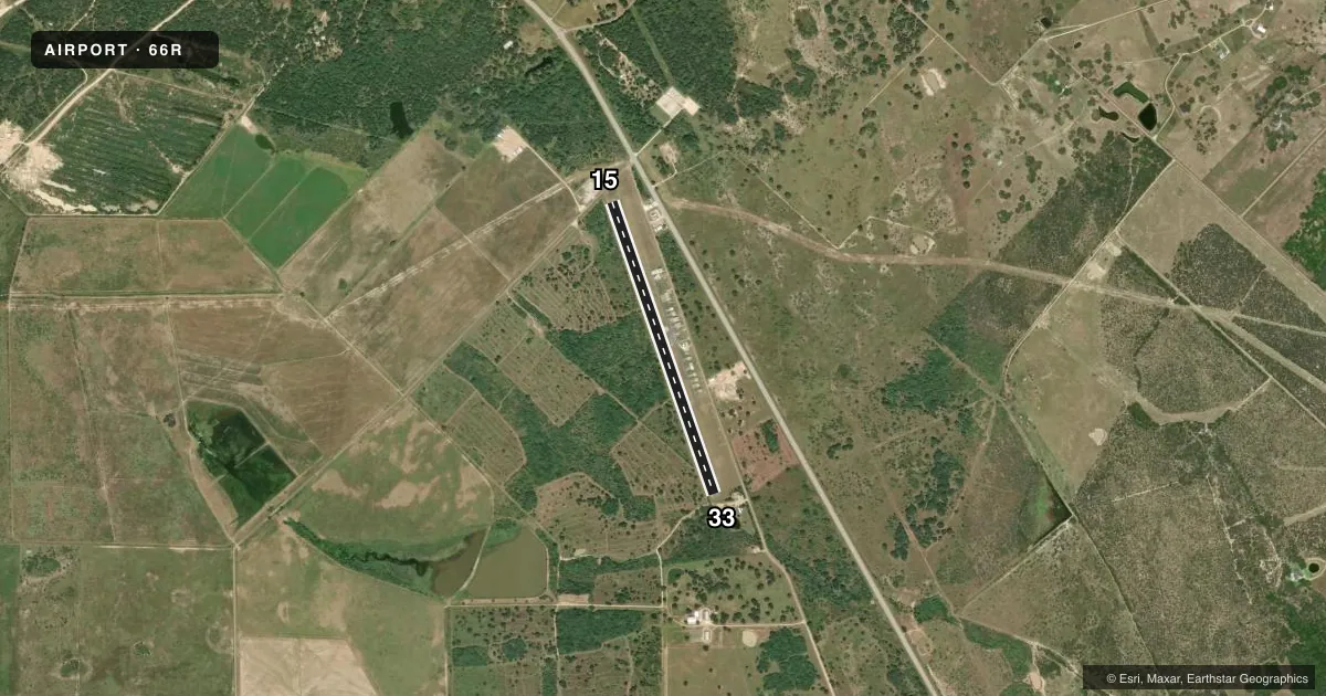
Runways & pattern
Full pagePattern entry · RWY 15
LEFT TRAFFICRunway end performance
| End | TORA | TODA | ASDA | LDA | VGSI | Approach lights | Obstruction |
|---|---|---|---|---|---|---|---|
| 15 | — | — | — | — | PAPI 2-box left | — | 15', road, 201' from thr, 135' R of cntrln, slope 0 |
| 33 | — | — | — | — | PAPI 2-box left | — | 30', trees, 201' from thr, 50' R of cntrln, slope 0 |
Declared distances in feet. TORA = takeoff run available, TODA = takeoff distance, ASDA = accelerate-stop, LDA = landing distance.
Airport sketch
Runways drawn to scale from FAA survey coordinates, rendered over satellite imagery. Not for navigation.
Approaches & charts
Services on the field
Fuel grades, oxygen, maintenance, ramp storage and lighting — as declared to the FAA by the airport operator.
Fuel & services
- Fuel
- 100LLA
- Oxygen (bottled)
- Not available
- Airframe repair
- Not available
- Power plant repair
- Not available
Ramp & ground
- Transient storage
- Tie-down
- Landing fee
- No fee published
- Lighting schedule
- SEE RMK
- Beacon schedule
- SS-SR
- Beacon
- White / Green (civil land)(WG)
- Wind indicator
- Lighted
- Segmented circle
- Yes
Fuel & FBOs
Cheapest 100LL and Jet A on the field and nearby. Always confirm with the FBO before taxi.
Airport notes
Surface conditions, obstructions, local procedures, lighting outages and other notes published with each FAA cycle.
General notes
- DEER & BIRDS ON AND INVOF ARPT.
- FOR CD CTC HOUSTON APCH AT 281-443-5844 TO CNL IFR CALL 281-443-5888.
Lighting notes
- ACTVT MIRL RY 15/33 - CTAF.
Fuel notes
- 100LLSELF SVC FUEL.
Approach & departure obstructions
- 154 FT FENCE 0-175 FT DSTC, 85 FT R.
- 334 FT FENCE 0-120 FT DSTC; 4 FT FENCE 85 FT L, 25 FT TREES 140 FT DSTC, 100 FT L.
- 15APCH RATIO 0:1 AT DSPLCD THR OVR 20 FT TREE, O FT DSTC, 120 FT R.
- 33APCH RATIO 0:1 AT DSPLCD THR OVR 20 FT TREE 85 FT L.
Other notes
- PRVDD RWY IS LCTD TO PRVD 20:1 SLOPE OVER ELECTRIC LINE OR IF THE LINE IS PLACED UNDERGROUND.
- MANAGERCOUNTY JUDGE.
VFR map & nearby airports
VFR sectional. Tap any ICAO chip to open that airport.
Key facts · 66R
Answer card- ICAO
- 66R
- Name
- ROBERT R WELLS JR
- Location
- COLUMBUS, TEXAS
- Elevation
- 242 ft MSL
- Traffic pattern altitude
- 1,242 ft MSL (1,000 AGL)
- Control tower
- Non-towered (use CTAF)
- Total runways
- 1
- Longest runway
- 15/33 · 3,800 ft
- Published ILS approaches
- 0
- Published frequencies
- 1
- Magnetic variation
- 6°
- Current flight rules
- VFR
- Current wind
- 190° at 7 kt
- Favored runway now
- RWY 15
Robert R Wells Jr Airport (66R) is in Columbus, Texas. The field elevation is 242 ft MSL. It has one runway. Runway 15/33 is 3,800 ft long with an asphalt surface. There is no control tower, so CTAF 122.9 is the working frequency. No ILS approaches are published here.
The pattern altitude is not published. Use the standard 1,000 ft AGL for light piston traffic unless the current FAA Chart Supplement says otherwise. That puts the pattern at 1,242 ft MSL based on the listed field elevation. Medium intensity runway lights on 15/33 are pilot-activated by CTAF. Self-serve 100LL is available on field through Robert R. Wells Jr. Airport. It also carries JET A Prist.
A first-time arrival should pay attention to the published obstructions. Runway 15 has a fence near the approach area and a tree close to the displaced threshold on the right side. Runway 33 has a tree and fence issues near the approach path. More trees are left of the runway. Deer, birds and ultralight activity are also reported on and near the airport. For IFR work, Houston Approach handles clearance delivery and IFR cancellation by phone. Check the current FAA Chart Supplement for any updated local procedures before you go.