METAR & TAF KGYB
Current METAR
Observed 03:15Z
KGYB 270315Z AUTO 18007KT 10SM CLR 29/23 A3001 RMK AO2 T02910230
- Wind
- 180° @ 7 kt
- Visibility
- 10 SM
- Temp / Dew
- 29°C / 23°C
- Altimeter
- 30.01 inHg
- Clouds
- CLR
- Density alt
- 2,169 ft
- Ceiling
- Unlimited
- Rules
- VFR
Airport info & contacts
Manager on record, flight service, ARTCC, attendance schedule and pattern altitude — published by the FAA and refreshed every 28 days.
Location
- From city
- 3 NM W
- VFR sectional
- HOUSTON
- ARTCC
- ZHU · HOUSTON
- NOTAM facility
- GYB (NOTAM-D)
Airport manager
- Name
- KYLE WEISS
- Phone
- 979-542-6081
- Address
- 1234 CR 206, GIDDINGS TX 78942
Flight service · Hours
- FSS CXO
- MONTGOMERY COUNTY1-800-WX-BRIEF
- Attendance
- MON-FRI · 0800-1700
Frequencies
Tap any row to copy the frequency to your clipboard.
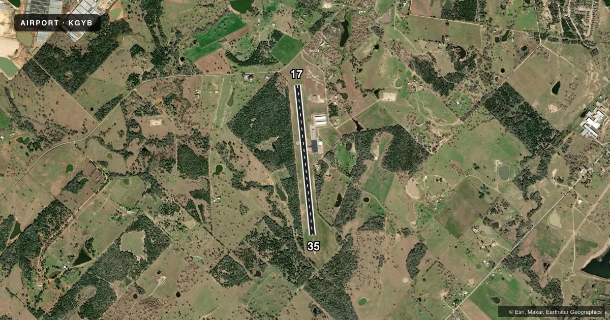
Runways & pattern
Full pagePattern entry · RWY 17
LEFT TRAFFICRunway end performance
| End | TORA | TODA | ASDA | LDA | VGSI | Approach lights | Obstruction |
|---|---|---|---|---|---|---|---|
| 17 | — | — | — | — | PAPI 2-box left(3.75°) | — | 44', trees, 520' from thr, 260' R of cntrln, slope 7 |
| 35 | — | — | — | — | PAPI 2-box left(3.4°) | — | 45', trees, 320' from thr, 256' R of cntrln, slope 2 |
Declared distances in feet. TORA = takeoff run available, TODA = takeoff distance, ASDA = accelerate-stop, LDA = landing distance.
Airport sketch
Runways drawn to scale from FAA survey coordinates, rendered over satellite imagery. Not for navigation.
Approaches & charts
Services on the field
Fuel grades, oxygen, maintenance, ramp storage and lighting — as declared to the FAA by the airport operator.
Fuel & services
- Fuel
- 100LLA
- Oxygen (bottled)
- Not available
- Oxygen (bulk)
- Not available
- Airframe repair
- Major
- Power plant repair
- Major
Ramp & ground
- Transient storage
- Tie-down
- Landing fee
- No fee published
- Customs
- Not available
- Lighting schedule
- SS-SR
- Beacon schedule
- SS-SR
- Beacon
- White / Green (civil land)(WG)
- Wind indicator
- Lighted
- Segmented circle
- Yes
Fuel & FBOs
Cheapest 100LL and Jet A on the field and nearby. Always confirm with the FBO before taxi.
Airport notes
Surface conditions, obstructions, local procedures, lighting outages and other notes published with each FAA cycle.
General notes
- DEER ON & INVOF ARPT.
- FOR CD CTC AUSTIN APCH AT 512-369-7865.
Fuel notes
- 100LL100LL & JET A 24 HR SELF SERVE.
Approach & departure obstructions
- 175 FT FENCE, 0-77 FT DSTC, 222 FT L.
VFR map & nearby airports
VFR sectional. Tap any ICAO chip to open that airport.
Key facts · KGYB
Answer card- ICAO
- KGYB
- Name
- GIDDINGS-LEE COUNTY
- Location
- GIDDINGS, TEXAS
- Elevation
- 484.1 ft MSL
- Traffic pattern altitude
- 1,484.1 ft MSL (1,000 AGL)
- Control tower
- Non-towered (use CTAF)
- Total runways
- 1
- Longest runway
- 17/35 · 4,000 ft
- Published ILS approaches
- 0
- Published frequencies
- 4
- Magnetic variation
- 6°
- Current flight rules
- VFR
- Current wind
- 180° at 7 kt
- Favored runway now
- RWY 17
Giddings-Lee County Airport (KGYB) sits in Giddings, Texas. The field elevation is 484.1 ft MSL. It has one runway. Runway 17/35 is 4,000 ft long with an asphalt surface. The airport is non-towered. Pattern altitude is not published, so light piston traffic should plan on the standard 1,000 ft AGL unless the current Chart Supplement says otherwise.
No ILS approaches are published here. Clearance delivery goes through Austin Approach at 512-369-7865. CTAF and UNICOM are both 123.05. Published remarks also note 24-hour self-serve 100LL and Jet A. That is useful for late arrivals or early departures. There is also a fence near the departure end of runway 17. Deer are reported on and near the airport. Expect wildlife vigilance on taxi, takeoff and landing.
For a first-time arrival, the main things to plan for are the non-towered environment, the single 4,000 ft runway and the wildlife risk. The runway is short enough that performance planning matters, especially on hot Texas days. Check the current FAA Chart Supplement for any updated remarks before you go.