METAR & TAF KPWG
Current METAR
Observed 12:56Z
KPWG 271256Z AUTO 19007KT 10SM CLR 26/23 A2999 RMK AO2 SLP145 T02610233
- Wind
- 190° @ 7 kt
- Visibility
- 10 SM
- Temp / Dew
- 26°C / 23°C
- Altimeter
- 29.99 inHg
- Clouds
- CLR
- Density alt
- 1,967 ft
- Ceiling
- Unlimited
- Rules
- VFR
Airport info & contacts
Manager on record, flight service, ARTCC, attendance schedule and pattern altitude — published by the FAA and refreshed every 28 days.
Location
- From city
- 4 NM W
- VFR sectional
- SAN ANTONIO
- ARTCC
- ZFW · FORT WORTH
- NOTAM facility
- PWG (NOTAM-D)
Airport manager
- Name
- BARRY LIGHTFOOT
- Phone
- 254-848-5477
- Address
- PO BOX 192, MC GREGOR TX 76657
Flight service · Hours
- FSS FTW
- FORT WORTH1-800-WX-BRIEF
- Attendance
- 0700-1900
Frequencies
Tap any row to copy the frequency to your clipboard.
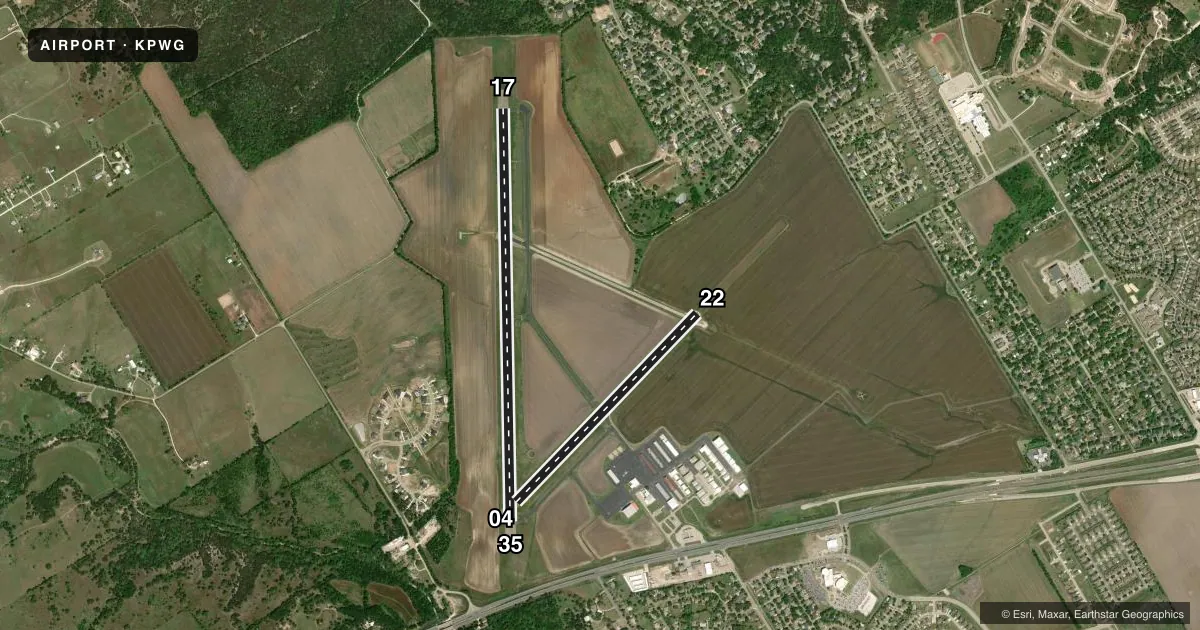
Runways & pattern
Full pagePattern entry · RWY 17
LEFT TRAFFIC| Runway | Heading (°M) | Length | Surface | Traffic |
|---|---|---|---|---|
| 17/35Favored | 173° / 353° | 5,501 ft | ASPH | Standard L |
| 04/22 | 38° / 218° | 3,484 ft | ASPH | Standard L |
Runway end performance
| End | TORA | TODA | ASDA | LDA | VGSI | Approach lights | Obstruction |
|---|---|---|---|---|---|---|---|
| 17 | — | — | — | — | PAPI 4-box left(3°) | — | 32', trees, 1100' from thr, 235' R of cntrln, slope 28 |
| 35 | — | — | — | — | PAPI 4-box left(3°) | — | 42', trees, 1200' from thr, 680' R of cntrln, slope 23 |
| 04 | — | — | — | — | — | — | 80', trees, 2650' from thr, 375' R of cntrln, slope 30 |
Declared distances in feet. TORA = takeoff run available, TODA = takeoff distance, ASDA = accelerate-stop, LDA = landing distance.
Airport sketch
Runways drawn to scale from FAA survey coordinates, rendered over satellite imagery. Not for navigation.
Approaches & charts
Services on the field
Fuel grades, oxygen, maintenance, ramp storage and lighting — as declared to the FAA by the airport operator.
Fuel & services
- Fuel
- 100LLA1+
- Oxygen (bottled)
- HIGH/LOW
- Oxygen (bulk)
- HIGH/LOW
- Airframe repair
- Major
- Power plant repair
- Major
- Other services
- AGRI,CHTR,INSTR,RNTL,SALES
Ramp & ground
- Transient storage
- Tie-down
- Hangar
- Landing fee
- No fee published
- Customs
- Not available
- Lighting schedule
- SEE RMK
- Beacon schedule
- SS-SR
- Beacon
- White / Green (civil land)(WG)
- Wind indicator
- Lighted
- Segmented circle
- Yes
Fuel & FBOs
Cheapest 100LL and Jet A on the field and nearby. Always confirm with the FBO before taxi.
Airport notes
Surface conditions, obstructions, local procedures, lighting outages and other notes published with each FAA cycle.
General notes
- CALM WIND LESS THAN 5 KNOTS USE RWY 17.
- 2550 FT MSL TWRS, 8 MILES SOUTH RWY 35 END.
- FOR CD IF UNA VIA GCO CTC FORT WORTH ARTCC AT 817-858-7584.
Lighting notes
- ACTVT REIL RWY 17 - CTAF. MIRL RWY 17/35 PRESET LOW INTST; TO INCR INTST ACTVT - CTAF.
Fuel notes
- 100LLAFT HRS FUEL CALL 254-379-8204. CALL-IN FEE. MILITARY FUEL CONTRACT.
Other notes
- THIS AIRPORT HAS BEEN SURVEYED BY THE NATIONAL GEODETIC SURVEY.
- MANAGEROR 254-848-2345. (FBO) 254-840-2855 (POLICE)
VFR map & nearby airports
VFR sectional. Tap any ICAO chip to open that airport.
Key facts · KPWG
Answer card- ICAO
- KPWG
- Name
- MC GREGOR EXEC
- Location
- WACO, TEXAS
- Elevation
- 591.7 ft MSL
- Traffic pattern altitude
- 1,591.7 ft MSL (1,000 AGL)
- Control tower
- Non-towered (use CTAF)
- Total runways
- 2
- Longest runway
- 17/35 · 5,501 ft
- Published ILS approaches
- 0
- Published frequencies
- 5
- Magnetic variation
- 6°
- Current flight rules
- VFR
- Current wind
- 190° at 7 kt
- Favored runway now
- RWY 17
Mc Gregor Exec is in Waco, Texas. Field elevation is 591.7 ft MSL. The airport has two asphalt runways. Runway 17/35 is the longest at 5,501 ft. Runway 04/22 is 3,484 ft. There is no control tower. No ILS approaches are published. Pattern altitude is not published, so use the current Chart Supplement and standard traffic pattern judgment for the aircraft you are flying.
JAG Aviation is on the field. It carries 100LL and Jet A. Call ahead if you need current fuel or ramp details. Published remarks also note that runway 17 should be used when winds are calm and below 5 knots. That is useful to know before you set up for the pattern. There are also towers about 8 miles south of the runway 35 end at 2,550 ft MSL. That matters if you are operating low in the area.
This is an uncontrolled field with CTAF and UNICOM on 123.05. Waco approach and departure frequencies are published for IFR coordination. Runway 17 has REILs on CTAF. The medium intensity runway lights on 17 and 35 start at low intensity. Use CTAF to raise them if needed. If you need clearance delivery and ground communications are not available, the Chart Supplement says to contact Fort Worth ARTCC.