METAR & TAF 7F7
7F7 does not publish a METAR.
Showing the nearest reporting station: KACT (WACO RGNL) · 21.3 NM away. Conditions at 7F7 may differ.
METAR · KACT
Observed 08:51Z
KACT 270851Z AUTO 20008KT 10SM CLR 26/22 A2995 RMK AO2 SLP133 T02610222 58003 $
- Wind
- 200° @ 8 kt
- Visibility
- 10 SM
- Temp / Dew
- 26°C / 22°C
- Altimeter
- 29.95 inHg
- Clouds
- CLR
- Density alt
- 2,225 ft
- Ceiling
- Unlimited
- Rules
- VFR
Airport info & contacts
Manager on record, flight service, ARTCC, attendance schedule and pattern altitude — published by the FAA and refreshed every 28 days.
Location
- From city
- 2 NM N
- VFR sectional
- SAN ANTONIO
- ARTCC
- ZFW · FORT WORTH
- NOTAM facility
- FTW (NOTAM-D)
Airport manager
- Name
- TIM TALLEY
- Phone
- 254-675-3771
- Address
- PO BOX 249, CLIFTON TX 76634
Flight service · Hours
- FSS FTW
- FORT WORTH1-800-WX-BRIEF
- Attendance
- MON-FRI · 0800-1630
Frequencies
Tap any row to copy the frequency to your clipboard.
Runways & pattern
Full pagePattern entry · RWY 14
LEFT TRAFFICRunway end performance
| End | TORA | TODA | ASDA | LDA | VGSI | Approach lights | Obstruction |
|---|---|---|---|---|---|---|---|
| 14 | — | — | — | — | PAPI 2-box left(3°) | — | — |
| 32 | — | — | — | — | PAPI 2-box right(3°) | — | 32', trees, 201' from thr, 115' R of cntrln, slope 0 |
Declared distances in feet. TORA = takeoff run available, TODA = takeoff distance, ASDA = accelerate-stop, LDA = landing distance.
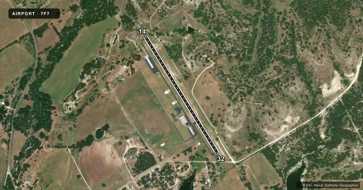
Airport sketch
Runways drawn to scale from FAA survey coordinates, rendered over satellite imagery. Not for navigation.
Approaches & charts
Services on the field
Fuel grades, oxygen, maintenance, ramp storage and lighting — as declared to the FAA by the airport operator.
Fuel & services
- Fuel
- 100LL
- Oxygen (bottled)
- Low pressure
- Airframe repair
- Major
- Power plant repair
- Major
- Other services
- AGRI,INSTR
Ramp & ground
- Transient storage
- Tie-down
- Hangar
- Landing fee
- No fee published
- Customs
- Not available
- Lighting schedule
- SEE RMK
- Beacon schedule
- SS-SR
- Beacon
- White / Green (civil land)(WG)
- Wind indicator
- Lighted
- Segmented circle
- Yes
Fuel & FBOs
Cheapest 100LL and Jet A on the field and nearby. Always confirm with the FBO before taxi.
Airport notes
Surface conditions, obstructions, local procedures, lighting outages and other notes published with each FAA cycle.
General notes
- STEEP DROP OFF NORTH OF RWY 14.
- SECURITY GATE LOCKED AFTER HRS. FOR ACCESS CONTACT 254-675-6620.
- FOR CD CTC FORT WORTH ARTCC AT 817-858-7584.
- NO LINE OF SIGHT BETWEEN RWY ENDS.
Lighting notes
- SS-SR MIRL RWY 14/32 PRESET LOW INTST; TO INCR INTST - CTAF.
Approach & departure obstructions
- 328 FT FENCE, 43-199 FT DSTC, ACRS APCH.
- 32APCH SLOPE 10:1 TO DSPLCD THR OVR 32 FT TREE, 340 FT DSTC, 115 FT L.
Other notes
- 1FOR ARPT ATTENDANT ON SAT & SUN CALL 254-978-0020 OR 254-253-0859; AFT HR FEE.
VFR map & nearby airports
VFR sectional. Tap any ICAO chip to open that airport.
Key facts · 7F7
Answer card- ICAO
- 7F7
- Name
- CLIFTON MUNI/ISENHOWER FLD
- Location
- CLIFTON, TEXAS
- Elevation
- 760 ft MSL
- Traffic pattern altitude
- 1,760 ft MSL (1,000 AGL)
- Control tower
- Non-towered (use CTAF)
- Total runways
- 1
- Longest runway
- 14/32 · 3,000 ft
- Published ILS approaches
- 0
- Published frequencies
- 2
- Magnetic variation
- 7°
- Current flight rules
- VFR
- Current wind
- 200° at 8 kt
- Favored runway now
- RWY 14
Clifton Muni/Isenhower Fld sits in Clifton, Texas at 760 ft MSL. It has one runway. Runway 14/32 is 3,000 ft of asphalt, which is the longest runway on the field. There is no control tower. CTAF and UNICOM are both 122.8. No ILS approaches are published here.
Pattern altitude is not published. Use the standard 1,000 ft AGL pattern unless local procedures or the current FAA Chart Supplement say otherwise. The field is small, so plan for self-announce traffic and close attention on the radio. Published remarks note that runway lights on 14/32 are preset to low intensity from sunset to sunrise. Use the common traffic advisory frequency to increase intensity if needed.
There are no on-field FBOs listed in the facts. For airport attendant service on weekends, call the numbers in the Chart Supplement. The security gate is locked after hours. There is also a steep drop off north of runway 14. Runway 32 has an 8-foot fence near the approach end. A tree on the 32 approach also creates a steeper-than-normal approach path. There is no line of sight between runway ends, so do not assume you can see opposite-end traffic from the runway. If you need clearance delivery, contact Fort Worth ARTCC. Check the current FAA Chart Supplement for any published noise or curfew restrictions before flying into the field.