METAR & TAF 3T8
3T8 does not publish a METAR.
Showing the nearest reporting station: KACT (WACO RGNL) · 7.8 NM away. Conditions at 3T8 may differ.
METAR · KACT
Observed 21:51Z
KACT 242151Z 18014KT 10SM CLR 34/22 A2997 RMK AO2 SLP141 T03390217 $
- Wind
- 180° @ 14 kt
- Visibility
- 10 SM
- Temp / Dew
- 34°C / 22°C
- Altimeter
- 29.97 inHg
- Clouds
- CLR
- Density alt
- 3,036 ft
- Ceiling
- Unlimited
- Rules
- VFR
Airport info & contacts
Manager on record, flight service, ARTCC, attendance schedule and pattern altitude — published by the FAA and refreshed every 28 days.
Location
- From city
- 4 NM NW
- VFR sectional
- SAN ANTONIO
- ARTCC
- ZFW · FORT WORTH
- NOTAM facility
- FTW (NOTAM-D)
Airport manager
- Name
- DONALD W. BAKER
- Phone
- 817-909-8044
- Address
- 381 BAKER RANCH ROAD, CHINA SPRING TX 76633
Flight service · Hours
- FSS FTW
- FORT WORTH1-800-WX-BRIEF
- Attendance
- Unattended
Frequencies
Tap any row to copy the frequency to your clipboard.
Runways & pattern
Full pagePattern entry · RWY 15
LEFT TRAFFICRunway end performance
| End | TORA | TODA | ASDA | LDA | VGSI | Approach lights | Obstruction |
|---|---|---|---|---|---|---|---|
| 15 | — | — | — | — | — | — | 8', fence, 160' from thr, 125' R of cntrln, slope 20 |
| 33 | — | — | — | — | — | — | 10', road, 0' from thr, 125' R of cntrln, slope 1 |
Declared distances in feet. TORA = takeoff run available, TODA = takeoff distance, ASDA = accelerate-stop, LDA = landing distance.
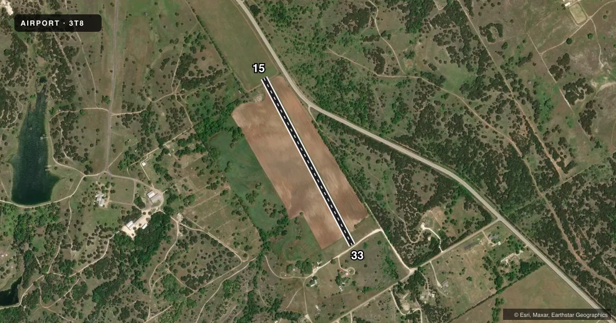
Airport sketch
Runways drawn to scale from FAA survey coordinates, rendered over satellite imagery. Not for navigation.
Approaches & charts
Services on the field
Fuel grades, oxygen, maintenance, ramp storage and lighting — as declared to the FAA by the airport operator.
Fuel & services
- Fuel
- Not available
Ramp & ground
- Transient storage
- Tie-down
- Wind indicator
- Yes
- Segmented circle
- No
Fuel & FBOs
Cheapest 100LL and Jet A on the field and nearby. Always confirm with the FBO before taxi.
Airport notes
Surface conditions, obstructions, local procedures, lighting outages and other notes published with each FAA cycle.
General notes
- DEER AND WILD HOGS ON & INVOF RY.
- FOR CD CTC FORT WORTH ARTCC AT 817-858-7584.
- 100 FT + HIGH TENSION POWER LINE (MARKED) 2500 FT NW OF RWY 15 END.
VFR map & nearby airports
VFR sectional. Tap any ICAO chip to open that airport.
Key facts · 3T8
Answer card- ICAO
- 3T8
- Name
- WILDCAT CANYON
- Location
- CHINA SPRING, TEXAS
- Elevation
- 660 ft MSL
- Traffic pattern altitude
- 1,660 ft MSL (1,000 AGL)
- Control tower
- Non-towered (use CTAF)
- Total runways
- 1
- Longest runway
- 15/33 · 2,450 ft
- Published ILS approaches
- 0
- Published frequencies
- 1
- Magnetic variation
- 7°
- Current flight rules
- VFR
- Current wind
- 180° at 14 kt
- Favored runway now
- RWY 15
Wildcat Canyon (3T8) sits in China Spring, Texas. Field elevation is 660 ft MSL. The airport has one runway. Runway 15/33 is 2,450 ft of turf, which makes it a short-field, light-aircraft strip rather than a place to plan on long pavement margins.
There is no control tower. CTAF is 122.9. No ILS approaches are published. Pattern altitude is not published. Use the standard 1,000 ft AGL pattern for light piston operations unless the current FAA Chart Supplement says otherwise. The published runway headings are 152° and 332° magnetic.
No on-field FBOs are listed. Check with the airport operator or the FBO directly by phone before you go if you need fuel or other services. The published remarks matter here. Deer and wild hogs are reported on the runway area. There is also a 100-foot high tension power line marked about 2,500 feet northwest of the runway 15 end. Clearance delivery is handled through Fort Worth ARTCC at 817-858-7584. For a first-time arrival, treat this as a small turf field with wildlife and obstacle awareness. Plan a conservative approach. Keep an eye out on rollout. Verify current details in the FAA Chart Supplement before departure.