METAR & TAF KCNW
Current METAR
Observed 23:55Z
KCNW 262355Z 15006KT 10SM CLR
- Wind
- 150° @ 6 kt
- Visibility
- 10 SM
- Temp / Dew
- —
- Altimeter
- —
- Clouds
- CLR
- Density alt
- —
- Ceiling
- Unlimited
- Rules
- VFR
Airport info & contacts
Manager on record, flight service, ARTCC, attendance schedule and pattern altitude — published by the FAA and refreshed every 28 days.
Location
- From city
- 8 NM NE
- VFR sectional
- SAN ANTONIO
- ARTCC
- ZFW · FORT WORTH
- NOTAM facility
- FTW (NOTAM-D)
Airport manager
- Name
- JOSEPH CAMPBELL
- Phone
- 254-867-2286
- Address
- 3801 CAMPUS DRIVE, WACO TX 76705
Flight service · Hours
- FSS FTW
- FORT WORTH1-800-WX-BRIEF
- Attendance
- MON-FRI · 0600-1800
Frequencies
Tap any row to copy the frequency to your clipboard.
Runways & pattern
Full pagePattern entry · RWY 17L
LEFT TRAFFIC| Runway | Heading (°M) | Length | Surface | Traffic |
|---|---|---|---|---|
| 17L/35RFavored | 174° / 354° | 8,600 ft | ASPH | 35R R |
| 17R/35L | 174° / 354° | 6,291 ft | CONC | 17R R |
Runway end performance
| End | TORA | TODA | ASDA | LDA | VGSI | Approach lights | Obstruction |
|---|---|---|---|---|---|---|---|
| 17L | — | — | — | — | PAPI 4-box right(3°) | MALSR | 44', trees, 1929' from thr, 790' R of cntrln, slope 39 |
| 35R | — | — | — | — | PAPI 4-box left(3°) | — | 67', trees, 2515' from thr, 750' R of cntrln, slope 34 |
| 35L | — | — | — | — | — | — | 48', trees, 1560' from thr, 410' R of cntrln, slope 28 |
Declared distances in feet. TORA = takeoff run available, TODA = takeoff distance, ASDA = accelerate-stop, LDA = landing distance.
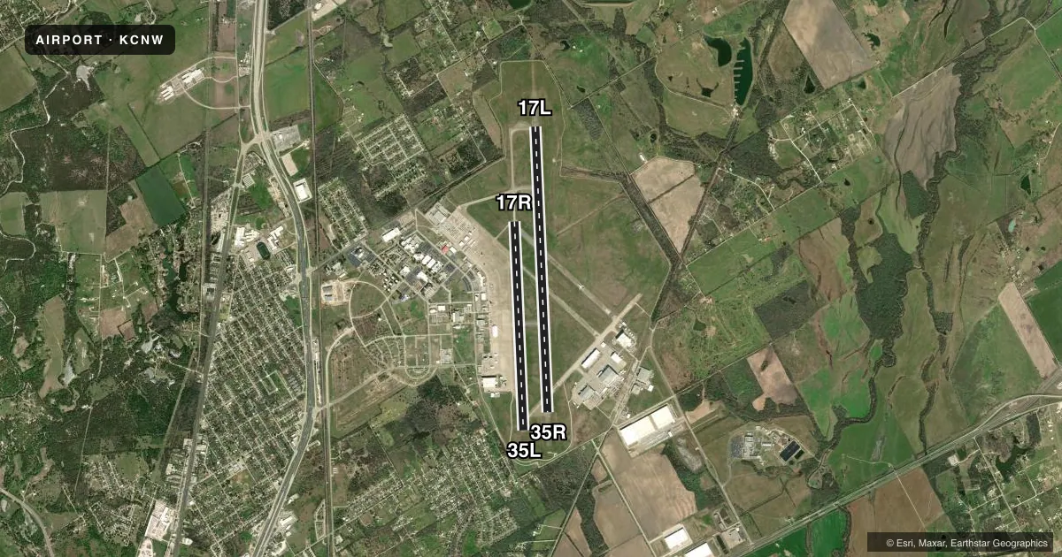
Airport sketch
Runways drawn to scale from FAA survey coordinates, rendered over satellite imagery. Not for navigation.
Approaches & charts
ILS · 1
Services on the field
Fuel grades, oxygen, maintenance, ramp storage and lighting — as declared to the FAA by the airport operator.
Fuel & services
- Fuel
- 100LLA
- Airframe repair
- Minor
- Power plant repair
- Minor
- Other services
- AMB,INSTR
Ramp & ground
- Transient storage
- Tie-down
- Landing fee
- No fee published
- Customs
- Not available
- Lighting schedule
- SEE RMK
- Beacon schedule
- SS-SR
- Beacon
- White / Green (civil land)(WG)
- Wind indicator
- Lighted
- Segmented circle
- Yes
Fuel & FBOs
Cheapest 100LL and Jet A on the field and nearby. Always confirm with the FBO before taxi.
Airport notes
Surface conditions, obstructions, local procedures, lighting outages and other notes published with each FAA cycle.
General notes
- EXTSV FLT TRNG IN CLASS D AIRSPACE SFC TO 3000 FT AGL.
- APU AVBL FOR JET ACFT.
- RWY 17R-35L NOT LGTD. MAY BE USED FOR TAXI AND HEL OPNS.
- AMGR CELL 910-578-8509.
Lighting notes
- WHEN ATCT CLSD MIRL RWY 17L/35R PRESET LOW INTST; TO INCR INTST & ACTVT MALSR RWY 17L & PAPI RWY 17L & 35R - 121.7.
Approach & departure obstructions
- 17R17R/35L GREEN CNTRLN REFLECTORS ALONG FULL LENGTH OF RWY.
- 35LGREEN CNTRLN REFLECTORS ALONG FULL LENGTH OF RWY.
VFR map & nearby airports
VFR sectional. Tap any ICAO chip to open that airport.
Key facts · KCNW
Answer card- ICAO
- KCNW
- Name
- TSTC WACO
- Location
- WACO, TEXAS
- Elevation
- 470.2 ft MSL
- Traffic pattern altitude
- 1,470.2 ft MSL (1,000 AGL)
- Control tower
- Towered · 0700-2300
- Total runways
- 2
- Longest runway
- 17L/35R · 8,600 ft
- Published ILS approaches
- 1
- Published frequencies
- 8
- Magnetic variation
- 4°
- Current flight rules
- VFR
- Current wind
- 150° at 6 kt
- Favored runway now
- RWY 17L
TSTC Waco sits in Waco, Texas. Field elevation is 470.2 ft MSL. The airport has two runways. The longest is 8,600 ft on 17L/35R. The other runway is 17R/35L at 6,291 ft. The tower is open daily from 0700 to 2300. This field has one ILS approach to runway 17L.
Pattern altitude is not published. Use 1,000 ft AGL for light piston operations unless the current Chart Supplement or tower gives you something different. Expect a busy training environment. Published remarks say there is extensive flight training in Class D airspace from the surface to 3,000 ft AGL. That matters if you are arriving VFR. Keep your spacing tight and listen carefully for tower instructions.
Servion of Waco is on the field. It carries 100LL and Jet A. The airport also notes that the auxiliary power unit is available for jet aircraft. Runway 17R/35L has green centerline reflectors along the full length, but it is not lighted and may be used for taxi and helicopter operations. When the tower is closed, 17L/35R lights come up at low intensity by default. Use 121.7 to increase intensity and activate the MALSR on 17L plus the PAPI on 17L and 35R. The airport manager phone is listed in the Chart Supplement if you need current operational details.