METAR & TAF KLXY
Current METAR
Observed 06:55Z
KLXY 270655Z AUTO 18004KT 10SM CLR 25/21 A2998 RMK AO2 T02450207 TSNO
- Wind
- 180° @ 4 kt
- Visibility
- 10 SM
- Temp / Dew
- 25°C / 21°C
- Altimeter
- 29.98 inHg
- Clouds
- CLR
- Density alt
- 1,801 ft
- Ceiling
- Unlimited
- Rules
- VFR
Airport info & contacts
Manager on record, flight service, ARTCC, attendance schedule and pattern altitude — published by the FAA and refreshed every 28 days.
Location
- From city
- 3 NM SW
- VFR sectional
- HOUSTON
- ARTCC
- ZFW · FORT WORTH
- NOTAM facility
- LXY (NOTAM-D)
Airport manager
- Name
- CHRIS SAVAGE
- Phone
- 254-562-2857
- Address
- 4819 HIGHWAY 14 N, MEXIA TX 76667
Flight service · Hours
- FSS FTW
- FORT WORTH1-800-WX-BRIEF
- Attendance
- MON-FRI · 0800-1800
Frequencies
Tap any row to copy the frequency to your clipboard.
Runways & pattern
Full pagePattern entry · RWY 18
LEFT TRAFFICRunway end performance
| End | TORA | TODA | ASDA | LDA | VGSI | Approach lights | Obstruction |
|---|---|---|---|---|---|---|---|
| 18 | — | — | — | — | PAPI 2-box left(3°) | — | — |
| 36 | — | — | — | — | PAPI 2-box left(3°) | — | 40', trees, 450' from thr, 260' R of cntrln, slope 6 |
Declared distances in feet. TORA = takeoff run available, TODA = takeoff distance, ASDA = accelerate-stop, LDA = landing distance.
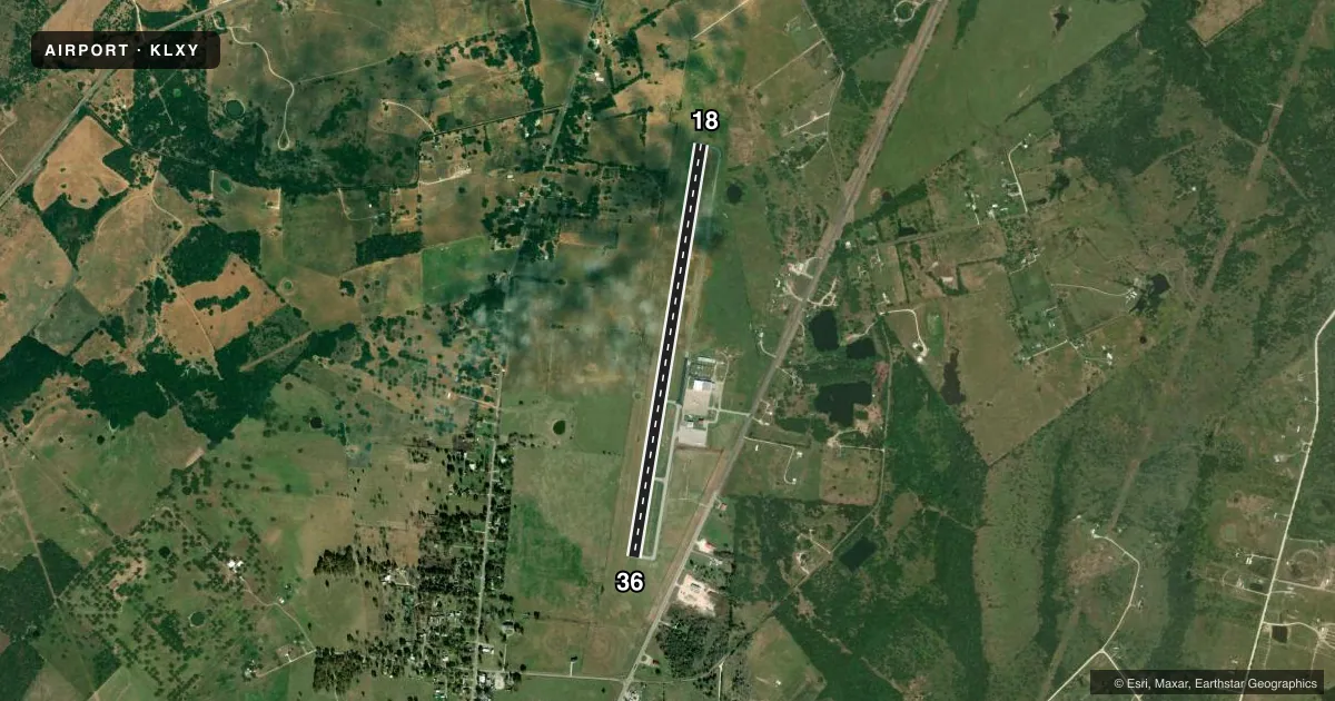
Airport sketch
Runways drawn to scale from FAA survey coordinates, rendered over satellite imagery. Not for navigation.
Approaches & charts
Services on the field
Fuel grades, oxygen, maintenance, ramp storage and lighting — as declared to the FAA by the airport operator.
Fuel & services
- Fuel
- 100LLA1+
- Oxygen (bulk)
- HIGH/LOW
- Airframe repair
- Major
- Power plant repair
- Major
- Other services
- SALES
Ramp & ground
- Transient storage
- Tie-down
- Landing fee
- No fee published
- Lighting schedule
- SEE RMK
- Beacon schedule
- SS-SR
- Beacon
- White / Green (civil land)(WG)
- Wind indicator
- Lighted
- Segmented circle
- Yes
Fuel & FBOs
Cheapest 100LL and Jet A on the field and nearby. Always confirm with the FBO before taxi.
Airport notes
Surface conditions, obstructions, local procedures, lighting outages and other notes published with each FAA cycle.
General notes
- FOR CD CTC FORT WORTH ARTCC AT 817-858-7584.
Lighting notes
- ACTVT MIRLS RWY 18/36 SS-SR - CTAF.
Fuel notes
- 100LLSELF-SERVE FUEL AVBL 24 HRS.
Approach & departure obstructions
- 18PAPI OTS
- 36PAPI OTS
Other notes
- 3EXC HOLS 0900-1500. OTR TIMES ON CALL.
- 3FOR AFT HRS ATNDT, CALL AMGR DURG ATNDD HRS.
- MANAGERFBO/AMGR.
VFR map & nearby airports
VFR sectional. Tap any ICAO chip to open that airport.
Key facts · KLXY
Answer card- ICAO
- KLXY
- Name
- MEXIA-LIMESTONE COUNTY
- Location
- MEXIA, TEXAS
- Elevation
- 544.7 ft MSL
- Traffic pattern altitude
- 1,544.7 ft MSL (1,000 AGL)
- Control tower
- Non-towered (use CTAF)
- Total runways
- 1
- Longest runway
- 18/36 · 5,000 ft
- Published ILS approaches
- 0
- Published frequencies
- 4
- Magnetic variation
- 4°
- Current flight rules
- VFR
- Current wind
- 180° at 4 kt
- Favored runway now
- RWY 18
Mexia-Limestone County Airport sits in Mexia, Texas. Field elevation is 544.7 ft MSL. The airport has one runway. Runway 18/36 is 5,000 ft long with asphalt surface. There is no control tower. Pattern altitude is not published, so use the standard 1,000 ft AGL for light piston traffic unless the current Chart Supplement says otherwise.
No ILS approaches are published here. The precision approach path indicator is out of service on both runway ends, so plan your visual descent carefully. Medium intensity runway lights on 18/36 are activated from sunset to sunrise by keying the CTAF. Self-serve 100LL is available 24 hours. Trim-Aire Aviation is on the field. It carries 100LL and Jet A. Call (254) 562-2857 for current service details.
This is an uncontrolled field with CTAF and UNICOM on 122.8. Waco Approach and Departure are on 127.65 and 352.0. For clearance delivery, contact Fort Worth ARTCC at 817-858-7584. The airport manager and FBO are available, but Wednesday attendance is limited to 0900 to 1500 except holidays. Other times are on call. If you are planning a night arrival or a first visit, verify the current Chart Supplement for any changes before you launch.