METAR & TAF KCRS
Current METAR
Observed 10:53Z
KCRS 271053Z AUTO 20008KT 10SM CLR 26/22 A2996 RMK AO2 SLP137 T02610222 $
- Wind
- 200° @ 8 kt
- Visibility
- 10 SM
- Temp / Dew
- 26°C / 22°C
- Altimeter
- 29.96 inHg
- Clouds
- CLR
- Density alt
- 1,827 ft
- Ceiling
- Unlimited
- Rules
- VFR
Airport info & contacts
Manager on record, flight service, ARTCC, attendance schedule and pattern altitude — published by the FAA and refreshed every 28 days.
Location
- From city
- 5 NM SE
- VFR sectional
- DALLAS-FT WORTH
- ARTCC
- ZFW · FORT WORTH
- NOTAM facility
- CRS (NOTAM-D)
Airport manager
- Name
- SAMUEL ZAMORA
- Phone
- 903-654-4857
- Address
- 9000 NAVARO DR., CORSICANA TX 75109
Flight service · Hours
- FSS FTW
- FORT WORTH1-800-WX-BRIEF
- Attendance
- MON-FRI · 0830-1630
- SAT · 0830-1530
Frequencies
Tap any row to copy the frequency to your clipboard.
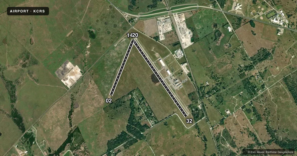
Runways & pattern
Full pagePattern entry · RWY 20
LEFT TRAFFIC| Runway | Heading (°M) | Length | Surface | Traffic |
|---|---|---|---|---|
| 14/32 | 139° / 319° | 5,004 ft | ASPH | Standard L |
| 02/20Favored | 16° / 196° | 3,200 ft | TURF | Standard L |
Runway end performance
| End | TORA | TODA | ASDA | LDA | VGSI | Approach lights | Obstruction |
|---|---|---|---|---|---|---|---|
| 14 | — | — | — | — | VASI 4-box right(3°) | — | 17', road, 480' from thr, 280' R of cntrln, slope 16 |
| 32 | — | — | — | — | PAPI 2-box left(3°) | — | 50', trees, 383' from thr, 290' R of cntrln, slope 3 |
| 02 | — | — | — | — | — | — | 45', pline, 930' from thr, 225' R of cntrln, slope 20 |
| 20 | — | — | — | — | — | — | 32', tree, 674' from thr, 170' R of cntrln, slope 21 |
Declared distances in feet. TORA = takeoff run available, TODA = takeoff distance, ASDA = accelerate-stop, LDA = landing distance.
Airport sketch
Runways drawn to scale from FAA survey coordinates, rendered over satellite imagery. Not for navigation.
Approaches & charts
Services on the field
Fuel grades, oxygen, maintenance, ramp storage and lighting — as declared to the FAA by the airport operator.
Fuel & services
- Fuel
- 100LLAMOGAS
- Oxygen (bulk)
- Not available
- Airframe repair
- Not available
- Power plant repair
- Not available
- Other services
- INSTR
Ramp & ground
- Transient storage
- Tie-down
- Hangar
- Landing fee
- No fee published
- Customs
- Not available
- Lighting schedule
- SEE RMK
- Beacon schedule
- SS-SR
- Beacon
- White / Green (civil land)(WG)
- Wind indicator
- Lighted
- Segmented circle
- Yes
Fuel & FBOs
Cheapest 100LL and Jet A on the field and nearby. Always confirm with the FBO before taxi.
Airport notes
Surface conditions, obstructions, local procedures, lighting outages and other notes published with each FAA cycle.
General notes
- RWY 02, 45 FT MKD PLINE AT 935 FT ACRS EXTDD CNTRLN.
- BIRDS & WILDLIFE ON & INVOF ARPT.
- FOR CD CTC FORT WORTH ARTCC AT 817-858-7584.
Lighting notes
- MIRL RWY 14/32 PRESET MED INTST; TO INCR INTST & ACTVT - CTAF.
Fuel notes
- 100LL100 LL AVBL SELF-SERVE ONLY.
Approach & departure obstructions
- 02RWY 2 & 20 ENDS MKD W/8 WHITE SQUARES.
- 0240 FT MKD PLINE, 918 FT DSTC, 205 FT L, OBSTN CLNC SLOPE 16:1.
Other notes
- THIS AIRPORT HAS BEEN SURVEYED BY THE NATIONAL GEODETIC SURVEY.
- MANAGERALSO 903-654-4878. 430-236-9042, AMGR CELL.
VFR map & nearby airports
VFR sectional. Tap any ICAO chip to open that airport.
Key facts · KCRS
Answer card- ICAO
- KCRS
- Name
- C DAVID CAMPBELL FLD-CORSICANA MUNI
- Location
- CORSICANA, TEXAS
- Elevation
- 448.6 ft MSL
- Traffic pattern altitude
- 1,448.6 ft MSL (1,000 AGL)
- Control tower
- Non-towered (use CTAF)
- Total runways
- 2
- Longest runway
- 14/32 · 5,004 ft
- Published ILS approaches
- 0
- Published frequencies
- 2
- Magnetic variation
- 6°
- Current flight rules
- VFR
- Current wind
- 200° at 8 kt
- Favored runway now
- RWY 20
C David Campbell Fld-Corsicana Muni sits in Corsicana, Texas. Field elevation is 448.6 ft MSL. The airport has two runways. The longest is runway 14/32 at 5,004 ft. Runway 02/20 is turf and measures 3,200 ft. There is no control tower. CTAF and UNICOM are both 122.8. No ILS approaches are published, so plan with the current chart and your own approach setup.
Pattern altitude is not published. Use 1,000 ft AGL for light piston traffic unless the current FAA Chart Supplement says otherwise. The on-field FBO is Corsicana Municipal Airport. It carries 100LL and Jet A. 100LL is self-serve only. For a first visit, pay attention to the runway 02 notes. There is a marked power line 918 ft from the threshold and 205 ft left of centerline. Another marked power line crosses the extended centerline 935 ft beyond runway 02. Birds and wildlife are also reported on and near the field. Runway 14/32 has preset medium intensity lights. Use the CTAF to increase intensity and activate them. For clearance delivery, contact Fort Worth ARTCC.