METAR & TAF F41
F41 does not publish a METAR.
Showing the nearest reporting station: KJWY (MID-WAY RGNL) · 14.8 NM away. Conditions at F41 may differ.
METAR · KJWY
Observed 20:55Z
KJWY 262055Z AUTO 20009KT 10SM CLR 36/19 A2998 RMK AO2 T03600186 56019 $
- Wind
- 200° @ 9 kt
- Visibility
- 10 SM
- Temp / Dew
- 36°C / 19°C
- Altimeter
- 29.98 inHg
- Clouds
- CLR
- Density alt
- 3,066 ft
- Ceiling
- Unlimited
- Rules
- VFR
Airport info & contacts
Manager on record, flight service, ARTCC, attendance schedule and pattern altitude — published by the FAA and refreshed every 28 days.
Location
- From city
- 2 NM W
- VFR sectional
- DALLAS-FT WORTH
- ARTCC
- ZFW · FORT WORTH
- NOTAM facility
- FTW (NOTAM-D)
Airport manager
- Name
- ANDREA WECKMUELLER-BEHRINGER
- Phone
- 972-875-4279
- Address
- 107 N SHERMAN ST, P O BOX 220, ENNIS TX 75119-0220
Flight service · Hours
- FSS FTW
- FORT WORTH1-800-WX-BRIEF
- Attendance
- MON-FRI · 0800-1700
Frequencies
Tap any row to copy the frequency to your clipboard.
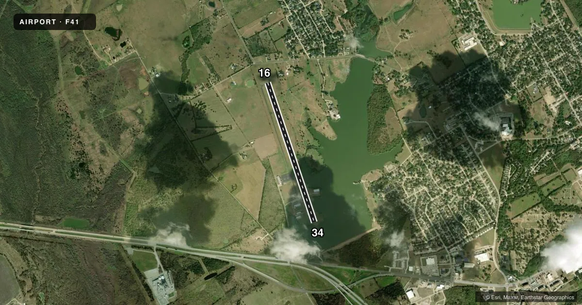
Runways & pattern
Full pagePattern entry · RWY 16
RIGHT TRAFFICRunway end performance
| End | TORA | TODA | ASDA | LDA | VGSI | Approach lights | Obstruction |
|---|---|---|---|---|---|---|---|
| 16 | — | — | — | — | PAPI 2-box left(3°) | — | 5', gnd, 201' from thr, 86' R of cntrln, slope 0 |
| 34 | — | — | — | — | PAPI 2-box left(3°) | — | 27', pline, 1125' from thr, 0' R of cntrln, slope 34 |
Declared distances in feet. TORA = takeoff run available, TODA = takeoff distance, ASDA = accelerate-stop, LDA = landing distance.
Airport sketch
Runways drawn to scale from FAA survey coordinates, rendered over satellite imagery. Not for navigation.
Approaches & charts
Services on the field
Fuel grades, oxygen, maintenance, ramp storage and lighting — as declared to the FAA by the airport operator.
Fuel & services
- Fuel
- 100LLA
- Oxygen (bottled)
- Not available
- Oxygen (bulk)
- Not available
- Airframe repair
- Major
- Power plant repair
- Major
- Other services
- PAJA
Ramp & ground
- Transient storage
- Tie-down
- Landing fee
- No fee published
- Customs
- Not available
- Lighting schedule
- SEE RMK
- Beacon schedule
- SS-SR
- Beacon
- White / Green (civil land)(WG)
- Wind indicator
- Lighted
- Segmented circle
- Yes
Fuel & FBOs
Cheapest 100LL and Jet A on the field and nearby. Always confirm with the FBO before taxi.
Airport notes
Surface conditions, obstructions, local procedures, lighting outages and other notes published with each FAA cycle.
General notes
- BIRDS ON AND INVOF ARPT.
- FOR CD CTC LONE STAR APCH AT 972-615-2799.
Lighting notes
- ACTVT REIL RWY 16 & 34; PAPI RWY 16 & 34; MIRL RWY 16/34, PRESET LOW INTST - CTAF.
Fuel notes
- 100LLFUEL SELF SERVE.
Approach & departure obstructions
- 16RISING GROUND 0 TO 5 FT FROM 0-199 FT DSTC, 88 FT L.
- 3420 FT BRUSH, 0-130 FT DSTC, ACRS APCH.
- 34APCH SLOPE 25:1 TO DSPLCD THR OVR 15 FT BRUSH, 382 FT DSTC.
Other notes
- MANAGERCITY/ARPT MGR.
- 16/34SFC CRACKING, LOOSE STONES.
VFR map & nearby airports
VFR sectional. Tap any ICAO chip to open that airport.
Key facts · F41
Answer card- ICAO
- F41
- Name
- ENNIS MUNI
- Location
- ENNIS, TEXAS
- Elevation
- 500.3 ft MSL
- Traffic pattern altitude
- 1,500.3 ft MSL (1,000 AGL)
- Control tower
- Non-towered (use CTAF)
- Total runways
- 1
- Longest runway
- 16/34 · 4,012 ft
- Published ILS approaches
- 0
- Published frequencies
- 3
- Magnetic variation
- 3°
- Current flight rules
- VFR
- Current wind
- 200° at 9 kt
- Favored runway now
- RWY 16
Ennis Muni sits in Ennis, Texas. Field elevation is 500.3 ft MSL. The airport has one runway. Runway 16/34 is 4,012 ft long on asphalt. There is no control tower. Lone Star Approach handles APCH and DEP on 125.2 and 343.65. CTAF is 122.9.
No ILS approaches are published here. Pattern altitude is not published, so use the current Chart Supplement or local procedures before you go. For light piston traffic, pilots often use a standard 1,000 ft AGL pattern when nothing else is published. Confirm before flight. Hammock Aviation Services is on the field. It carries 100LL and Jet A with Prist. Self-serve 100LL is published. The field also has runway end identifier lights, PAPI on both ends and medium intensity runway lights that are controlled by CTAF and preset to low intensity.
There are a few things to brief before arrival. Published remarks note rising ground and brush near runway 16. Brush also affects the approach to runway 34. There is also a displaced threshold note. The runway surface has cracking and loose stones. Birds are also reported on and near the airport. If you need clearance delivery, contact Lone Star Approach at the published phone number before departure. This is a non-towered field, so keep your radio work tight and verify the latest runway and lighting notes before you launch.