METAR & TAF KINJ
Current METAR
Observed 11:55Z
KINJ 271155Z AUTO 17005KT 10SM CLR 24/22 A2996 RMK AO2 T02390218 10284 20238
- Wind
- 170° @ 5 kt
- Visibility
- 10 SM
- Temp / Dew
- 24°C / 22°C
- Altimeter
- 29.96 inHg
- Clouds
- CLR
- Density alt
- 1,881 ft
- Ceiling
- Unlimited
- Rules
- VFR
Airport info & contacts
Manager on record, flight service, ARTCC, attendance schedule and pattern altitude — published by the FAA and refreshed every 28 days.
Location
- From city
- 5 NM N
- VFR sectional
- DALLAS-FT WORTH
- ARTCC
- ZFW · FORT WORTH
- NOTAM facility
- INJ (NOTAM-D)
Airport manager
- Name
- JOHN GRAHAM
- Phone
- 254-582-3731
- Address
- 1000 AIRPORT BLVD, SUITE 101, HILLSBORO TX 76645
Flight service · Hours
- FSS FTW
- FORT WORTH1-800-WX-BRIEF
- Attendance
- MON-SAT · 0800-1700
Frequencies
Tap any row to copy the frequency to your clipboard.
Runways & pattern
Full pagePattern entry · RWY 16
LEFT TRAFFICRunway end performance
| End | TORA | TODA | ASDA | LDA | VGSI | Approach lights | Obstruction |
|---|---|---|---|---|---|---|---|
| 16 | — | — | — | — | PAPI 2-box left(3°) | — | — |
| 34 | — | — | — | — | PAPI 2-box left(3°) | — | — |
Declared distances in feet. TORA = takeoff run available, TODA = takeoff distance, ASDA = accelerate-stop, LDA = landing distance.
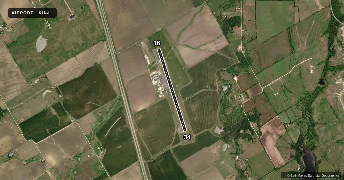
Airport sketch
Runways drawn to scale from FAA survey coordinates, rendered over satellite imagery. Not for navigation.
Approaches & charts
Services on the field
Fuel grades, oxygen, maintenance, ramp storage and lighting — as declared to the FAA by the airport operator.
Fuel & services
- Fuel
- 100LLA1+
- Airframe repair
- Major
- Power plant repair
- Major
- Other services
- AGRI,INSTR,PAJA
Ramp & ground
- Transient storage
- Tie-down
- Hangar
- Lighting schedule
- SEE RMK
- Beacon schedule
- SS-SR
- Beacon
- White / Green (civil land)(WG)
- Wind indicator
- Lighted
- Segmented circle
- Yes
Fuel & FBOs
Cheapest 100LL and Jet A on the field and nearby. Always confirm with the FBO before taxi.
Airport notes
Surface conditions, obstructions, local procedures, lighting outages and other notes published with each FAA cycle.
General notes
- NOISE SENSITIVE AREA: EXTEND PATTERN ON TKOF AND LNDG RWY 16 TO AVOID FLYING OVER HOUSES TO THE SE & EAST OF ARPT.
- SKYDIVING ACTVTY INVOF ARPT.
- FOR CD CTC FORT WORTH ARTCC AT 817-858-7584.
Lighting notes
- MIRL RWY 16/34 SS-SR PRESET LOW INTST; TO INCR INTST - CTAF.
Fuel notes
- 100LLFUEL 24 HR SELF SERVE.
VFR map & nearby airports
VFR sectional. Tap any ICAO chip to open that airport.
Key facts · KINJ
Answer card- ICAO
- KINJ
- Name
- HILLSBORO MUNI
- Location
- HILLSBORO, TEXAS
- Elevation
- 685.7 ft MSL
- Traffic pattern altitude
- 1,685.7 ft MSL (1,000 AGL)
- Control tower
- Non-towered (use CTAF)
- Total runways
- 1
- Longest runway
- 16/34 · 3,998 ft
- Published ILS approaches
- 0
- Published frequencies
- 3
- Magnetic variation
- 6°
- Current flight rules
- VFR
- Current wind
- 170° at 5 kt
- Favored runway now
- RWY 16
Hillsboro Muni (KINJ) sits in Hillsboro, Texas. Field elevation is 685.7 ft MSL. The airport has one runway. Runway 16/34 is 3,998 ft asphalt. That is the longest runway here. There is no control tower, so use CTAF 122.9 for local traffic calls. Waco approach and departure are on 127.65 and 352.0. No ILS approaches are published.
Pattern altitude is not published. Use the standard 1,000 ft AGL pattern unless current local guidance says otherwise. The airport sits in a busy training and transit area. Skydiving activity is in the vicinity. Runway 16 departures and arrivals need extra attention because the published noise-sensitive area calls for an extended pattern to avoid houses southeast and east of the field.
The on-field FBO is Hillsboro Municipal Airport. It carries 100LL and Jet A Prist. 100LL is available as 24-hour self-serve fuel. Runway 16/34 has medium intensity lights that come up at low intensity from sunset to sunrise. Use CTAF if you need to increase them. For clearance delivery, Fort Worth ARTCC can be reached at 817-858-7584. If you are planning a night or IFR arrival, verify the current Chart Supplement and get the latest local picture before you launch.