METAR & TAF KMNZ
Current METAR
Observed 14:55Z
KMNZ 271455Z AUTO 20010KT 8SM CLR 29/22 A2999 RMK AO2
- Wind
- 200° @ 10 kt
- Visibility
- 8 SM
- Temp / Dew
- 29°C / 22°C
- Altimeter
- 29.99 inHg
- Clouds
- CLR
- Density alt
- 3,211 ft
- Ceiling
- Unlimited
- Rules
- VFR
Airport info & contacts
Manager on record, flight service, ARTCC, attendance schedule and pattern altitude — published by the FAA and refreshed every 28 days.
Location
- From city
- 2 NM S
- VFR sectional
- SAN ANTONIO
- ARTCC
- ZFW · FORT WORTH
- NOTAM facility
- FTW (NOTAM-D)
Airport manager
- Name
- DEBBIE GRIEVE
- Phone
- 254-386-3939
- Address
- 200 E. MAIN, HAMILTON TX 76531
Flight service · Hours
- FSS FTW
- FORT WORTH1-800-WX-BRIEF
- Attendance
- INTMT
Frequencies
Tap any row to copy the frequency to your clipboard.
Runways & pattern
Full pagePattern entry · RWY 18
LEFT TRAFFICRunway end performance
| End | TORA | TODA | ASDA | LDA | VGSI | Approach lights | Obstruction |
|---|---|---|---|---|---|---|---|
| 18 | — | — | — | — | PAPI 2-box left(3°) | — | — |
| 36 | — | — | — | — | PAPI 2-box left(3°) | — | — |
Declared distances in feet. TORA = takeoff run available, TODA = takeoff distance, ASDA = accelerate-stop, LDA = landing distance.
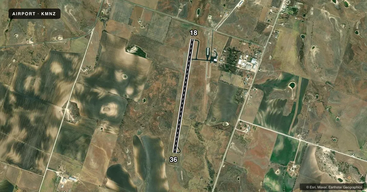
Airport sketch
Runways drawn to scale from FAA survey coordinates, rendered over satellite imagery. Not for navigation.
Approaches & charts
Services on the field
Fuel grades, oxygen, maintenance, ramp storage and lighting — as declared to the FAA by the airport operator.
Fuel & services
- Fuel
- 100LLA
- Oxygen (bottled)
- Not available
- Oxygen (bulk)
- Not available
- Airframe repair
- Not available
- Power plant repair
- Not available
- Other services
- GLD
Ramp & ground
- Transient storage
- Tie-down
- Landing fee
- No fee published
- Customs
- Not available
- Lighting schedule
- SEE RMK
- Beacon schedule
- SS-SR
- Beacon
- White / Green (civil land)(WG)
- Wind indicator
- Lighted
- Segmented circle
- Yes
Fuel & FBOs
Cheapest 100LL and Jet A on the field and nearby. Always confirm with the FBO before taxi.
Airport notes
Surface conditions, obstructions, local procedures, lighting outages and other notes published with each FAA cycle.
General notes
- GLIDER OPNS INVOF ARPT.
- FOR CD CTC FORT WORTH ARTCC AT 817-858-7584.
Lighting notes
- MIRL RWY 18/36 SS-SR PRESET LOW INTST; TO INCR INTST ACTVT - CTAF.
Fuel notes
- 100LLFUEL 24 HRS SELF-SERVE. FOR AFTR HRS ATNDT 254-784-5923.
Other notes
- GLDGLIDER TOW AVBL.
VFR map & nearby airports
VFR sectional. Tap any ICAO chip to open that airport.
Key facts · KMNZ
Answer card- ICAO
- KMNZ
- Name
- HAMILTON MUNI
- Location
- HAMILTON, TEXAS
- Elevation
- 1,304.8 ft MSL
- Traffic pattern altitude
- 2,304.8 ft MSL (1,000 AGL)
- Control tower
- Non-towered (use CTAF)
- Total runways
- 1
- Longest runway
- 18/36 · 5,012 ft
- Published ILS approaches
- 0
- Published frequencies
- 4
- Magnetic variation
- 7°
- Current flight rules
- VFR
- Current wind
- 200° at 10 kt
- Favored runway now
- RWY 18
Hamilton Muni sits in Hamilton, Texas. The field elevation is 1,304.8 ft MSL. It has one runway. Runway 18/36 is 5,012 ft long with an asphalt surface. The airport is not towered. Pattern altitude is not published, so use the standard 1,000 ft AGL for light piston traffic unless the current Chart Supplement says otherwise.
No ILS approaches are published here. The airport uses CTAF 122.7 for local traffic. UNICOM is also 122.7. For clearance delivery, Fort Worth ARTCC is listed in the remarks. The runway lights on 18/36 are preset to low intensity from sunset to sunrise. Use the CTAF to increase intensity if needed.
Hamilton Municipal Airport is the on-field FBO. It carries 100LL and Jet A Prist. 100LL is available 24 hours self-serve. Glider operations are in the vicinity of the airport. Glider tow is also available. That matters on arrival and departure. Expect to keep a sharp lookout for tow traffic and gliders near the pattern. If you are planning a night or low-visibility arrival, verify the lighting setup and current airport status before you go.