METAR & TAF KSEP
Current METAR
Observed 09:55Z
KSEP 270955Z AUTO 00000KT 10SM SCT110 22/18 A3001 RMK AO2 T02210176
- Wind
- 000° @ 0 kt
- Visibility
- 10 SM
- Temp / Dew
- 22°C / 18°C
- Altimeter
- 30.01 inHg
- Clouds
- SCT
- Density alt
- 2,367 ft
- Ceiling
- Unlimited
- Rules
- VFR
Airport info & contacts
Manager on record, flight service, ARTCC, attendance schedule and pattern altitude — published by the FAA and refreshed every 28 days.
Location
- From city
- 1 NM E
- VFR sectional
- DALLAS-FT WORTH
- ARTCC
- ZFW · FORT WORTH
- NOTAM facility
- SEP (NOTAM-D)
Airport manager
- Name
- SEAN CLEMMONS
- Phone
- 254-552-1224
- Address
- 1050 AIRPORT ROAD, STEPHENVILLE TX 76401
Flight service · Hours
- FSS FTW
- FORT WORTH1-800-WX-BRIEF
- Attendance
- MON-FRI · 0800-1700
- SAT · 0900-1330
Frequencies
Tap any row to copy the frequency to your clipboard.
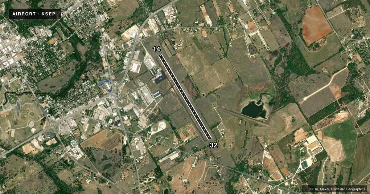
Runways & pattern
Full pagePattern entry · RWY 14
LEFT TRAFFICRunway end performance
| End | TORA | TODA | ASDA | LDA | VGSI | Approach lights | Obstruction |
|---|---|---|---|---|---|---|---|
| 14 | — | — | — | — | PAPI 2-box left | — | 40', tree, 915' from thr, 0' R of cntrln, slope 17 |
| 32 | — | — | — | — | PAPI 2-box left | — | 12', road, 201' from thr, 250' R of cntrln, slope 0 |
Declared distances in feet. TORA = takeoff run available, TODA = takeoff distance, ASDA = accelerate-stop, LDA = landing distance.
Airport sketch
Runways drawn to scale from FAA survey coordinates, rendered over satellite imagery. Not for navigation.
Approaches & charts
Services on the field
Fuel grades, oxygen, maintenance, ramp storage and lighting — as declared to the FAA by the airport operator.
Fuel & services
- Fuel
- 100LLA+
- Oxygen (bottled)
- Not available
- Oxygen (bulk)
- Not available
- Airframe repair
- Major
- Power plant repair
- Major
- Other services
- INSTR,PAJA,RNTL
Ramp & ground
- Transient storage
- Tie-down
- Landing fee
- No fee published
- Customs
- Not available
- Lighting schedule
- SS-SR
- Beacon schedule
- SS-SR
- Beacon
- White / Green (civil land)(WG)
- Wind indicator
- Lighted
- Segmented circle
- Yes
Fuel & FBOs
Cheapest 100LL and Jet A on the field and nearby. Always confirm with the FBO before taxi.
Airport notes
Surface conditions, obstructions, local procedures, lighting outages and other notes published with each FAA cycle.
General notes
- FOR CD CTC FORT WORTH ARTCC AT 817-858-7584.
- SKYDIVING ACTVTY ON AND INVOF ARPT.
- PRKG AT SELF-SVC FUEL PUMPS FOR RFLG ACFT ONLY. UNATNDD ACFT AT FUEL PUMPS PROHIBITED.
- RWY 14 CALM WIND RWY.
- DEER INVOF ARPT.
- ACFT NOT VSB FM OPPOSITE END OF RWY.
Fuel notes
- 100LL100LL SELF-SERVE ONLY
Approach & departure obstructions
- 3230 FT TREES, 193 FT DSTC, 245 FT R.
- 14PAPI OTS INDEFLY.
- 32PAPI OTS INDEFLY.
- 14CONTROLLING OBSTRUCTION EXCEEDS A 45 DEGREE SLOPE
Other notes
- THIS AIRPORT HAS BEEN SURVEYED BY THE NATIONAL GEODETIC SURVEY.
- MANAGERAMGR CELL: 254-964-6804
VFR map & nearby airports
VFR sectional. Tap any ICAO chip to open that airport.
Key facts · KSEP
Answer card- ICAO
- KSEP
- Name
- STEPHENVILLE CLARK RGNL
- Location
- STEPHENVILLE, TEXAS
- Elevation
- 1,321.4 ft MSL
- Traffic pattern altitude
- 2,321.4 ft MSL (1,000 AGL)
- Control tower
- Non-towered (use CTAF)
- Total runways
- 1
- Longest runway
- 14/32 · 4,209 ft
- Published ILS approaches
- 0
- Published frequencies
- 2
- Magnetic variation
- 7°
- Current flight rules
- VFR
- Current wind
- 000° at 0 kt
- Favored runway now
- –
Stephenville Clark Rgnl is in Stephenville, Texas. The field elevation is 1,321.4 ft MSL. It has one runway, 14/32, which is 4,209 ft long. There is no control tower. CTAF and UNICOM are both 122.8. No ILS approaches are published here.
Pattern altitude is not published. Use the standard 1,000 ft AGL for light piston operations unless local guidance says otherwise. Stephenville Aviation is on the field. It carries 100LL and Jet A Prist. 100LL is self-serve only. Parking unattended aircraft at the self-serve fuel pumps is prohibited.
A few operational items matter here. Skydiving and parachute activity occur on and near the airport. Deer are present in the area. There are trees and brush near the runway ends. That includes an obstruction near runway 32 and brush near runway 14. The PAPI is out of service indefinitely at both ends. Runway 14 is preferred with calm winds. For clearance delivery, contact Fort Worth ARTCC. If you are new to the field, plan for a non-towered arrival. Keep your scan active for parachute traffic. Treat the runway environment with care.