METAR & TAF F23
F23 does not publish a METAR.
Showing the nearest reporting station: KETN (EASTLAND MUNI) · 6.9 NM away. Conditions at F23 may differ.
METAR · KETN
Observed 03:55Z
KETN 270355Z AUTO 18003KT 10SM CLR 25/19 A2999 RMK AO2 T02470189
- Wind
- 180° @ 3 kt
- Visibility
- 10 SM
- Temp / Dew
- 25°C / 19°C
- Altimeter
- 29.99 inHg
- Clouds
- CLR
- Density alt
- 2,936 ft
- Ceiling
- Unlimited
- Rules
- VFR
Airport info & contacts
Manager on record, flight service, ARTCC, attendance schedule and pattern altitude — published by the FAA and refreshed every 28 days.
Location
- From city
- 2 NM S
- VFR sectional
- DALLAS-FT WORTH
- ARTCC
- ZFW · FORT WORTH
- NOTAM facility
- FTW (NOTAM-D)
Airport manager
- Name
- JARED CALVERT
- Phone
- 254-433-1267
- Address
- 1420 ODDIE ST, RANGER TX 76470
Flight service · Hours
- FSS FTW
- FORT WORTH1-800-WX-BRIEF
- Attendance
- DALGT
Frequencies
Tap any row to copy the frequency to your clipboard.
Runways & pattern
Full pagePattern entry · RWY 19
LEFT TRAFFICRunway end performance
| End | TORA | TODA | ASDA | LDA | VGSI | Approach lights | Obstruction |
|---|---|---|---|---|---|---|---|
| 01 | — | — | — | — | — | — | 20', trees, 200' from thr, 135' R of cntrln, slope 10 |
| 19 | — | — | — | — | — | — | 16', trees, 30' from thr, 76' R of cntrln, slope 1 |
Declared distances in feet. TORA = takeoff run available, TODA = takeoff distance, ASDA = accelerate-stop, LDA = landing distance.
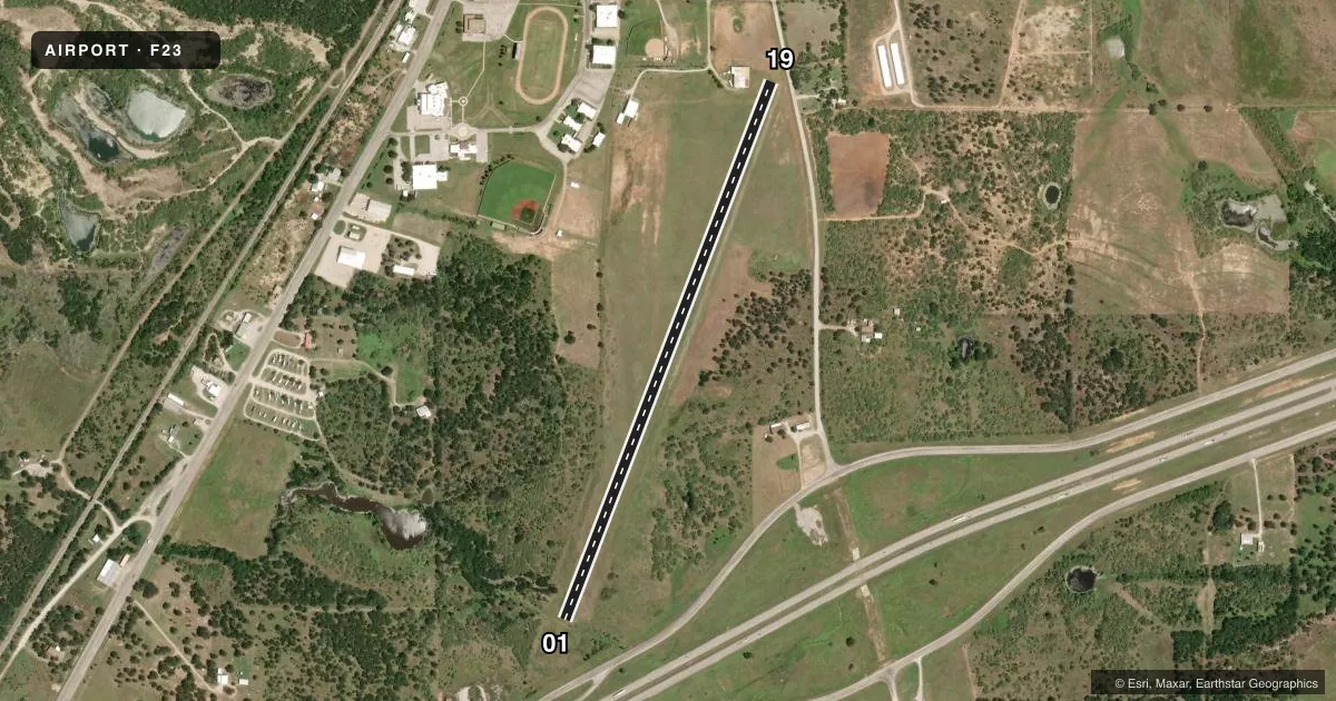
Airport sketch
Runways drawn to scale from FAA survey coordinates, rendered over satellite imagery. Not for navigation.
Approaches & charts
Services on the field
Fuel grades, oxygen, maintenance, ramp storage and lighting — as declared to the FAA by the airport operator.
Fuel & services
- Fuel
- Not available
Ramp & ground
- Transient storage
- Tie-down
- Hangar
- Landing fee
- No fee published
- Customs
- Not available
- Wind indicator
- Yes
- Segmented circle
- No
Fuel & FBOs
Cheapest 100LL and Jet A on the field and nearby. Always confirm with the FBO before taxi.
Airport notes
Surface conditions, obstructions, local procedures, lighting outages and other notes published with each FAA cycle.
General notes
- PEDESTRIAN TFC ON FLD AT TIMES.
- RWY 01 & 19 THR MKD BY WHITE TIRES.
- DEER ON & INVOF ARPT.
- FOR CD CTC FORT WORTH ARTCC AT 817-858-7584.
Other notes
- PRE-DATES THE ACT.
VFR map & nearby airports
VFR sectional. Tap any ICAO chip to open that airport.
Key facts · F23
Answer card- ICAO
- F23
- Name
- RANGER MUNI
- Location
- RANGER, TEXAS
- Elevation
- 1,470 ft MSL
- Traffic pattern altitude
- 2,470 ft MSL (1,000 AGL)
- Control tower
- Non-towered (use CTAF)
- Total runways
- 1
- Longest runway
- 01/19 · 3,415 ft
- Published ILS approaches
- 0
- Published frequencies
- 1
- Magnetic variation
- 7°
- Current flight rules
- VFR
- Current wind
- 180° at 3 kt
- Favored runway now
- RWY 19
Ranger Muni sits in Ranger, Texas. The field elevation is 1,470 ft MSL. It has one runway. The longest is runway 01/19 at 3,415 ft on turf. This is an uncontrolled field. CTAF is 122.9. No ILS approaches are published.
Pattern altitude is not published. Use the standard 1,000 ft AGL pattern unless the current FAA Chart Supplement says otherwise. That puts the light-piston pattern at about 2,470 ft MSL based on field elevation. The runway thresholds are marked by white tires. Deer are reported on and near the airport. Pedestrian traffic can also be on the field at times. Plan your arrival with that in mind.
There are no on-field FBOs listed. Contact the airport operator directly before arrival if you need local services. For clearance delivery, contact Fort Worth ARTCC at 817-858-7584. The field pre-dates the ACT, so expect a simple setup rather than a modern towered environment. Check the current FAA Chart Supplement for any published noise or operating restrictions before flying in.