METAR & TAF KMKN
Current METAR
Observed 16:35Z
KMKN 271635Z AUTO 10SM CLR 33/22 A3000 RMK AO2 T03330221
- Wind
- Calm
- Visibility
- 10 SM
- Temp / Dew
- 33°C / 22°C
- Altimeter
- 30.00 inHg
- Clouds
- CLR
- Density alt
- 3,780 ft
- Ceiling
- Unlimited
- Rules
- VFR
Airport info & contacts
Manager on record, flight service, ARTCC, attendance schedule and pattern altitude — published by the FAA and refreshed every 28 days.
Location
- From city
- 2 NM NE
- VFR sectional
- SAN ANTONIO
- ARTCC
- ZFW · FORT WORTH
- NOTAM facility
- MKN (NOTAM-D)
Airport manager
- Name
- ROBERT COBB
- Phone
- 325-330-0289
- Address
- 101 E. GRAND AVE, COMANCHE TX 76442
Flight service · Hours
- FSS FTW
- FORT WORTH1-800-WX-BRIEF
- Attendance
- Unattended
Frequencies
Tap any row to copy the frequency to your clipboard.
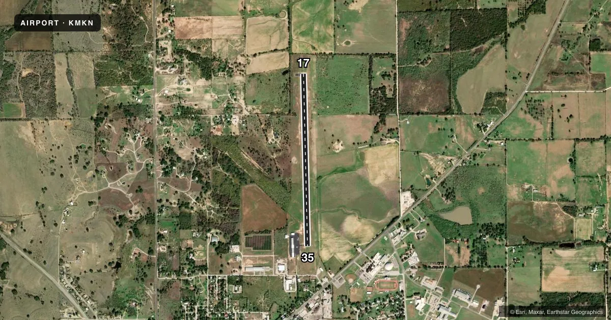
Runways & pattern
Full pagePattern entry · RWY 17
LEFT TRAFFICRunway end performance
| End | TORA | TODA | ASDA | LDA | VGSI | Approach lights | Obstruction |
|---|---|---|---|---|---|---|---|
| 17 | — | — | — | — | PAPI 2-box left(4°) | — | — |
| 35 | — | — | — | — | PAPI 2-box left(4°) | — | 58', tree, 1067' from thr, 250' R of cntrln, slope 14 |
Declared distances in feet. TORA = takeoff run available, TODA = takeoff distance, ASDA = accelerate-stop, LDA = landing distance.
Airport sketch
Runways drawn to scale from FAA survey coordinates, rendered over satellite imagery. Not for navigation.
Approaches & charts
Services on the field
Fuel grades, oxygen, maintenance, ramp storage and lighting — as declared to the FAA by the airport operator.
Fuel & services
- Fuel
- 100LLA
Ramp & ground
- Transient storage
- Tie-down
- Landing fee
- No fee published
- Customs
- Not available
- Lighting schedule
- SEE RMK
- Beacon schedule
- SS-SR
- Beacon
- White / Green (civil land)(WG)
- Wind indicator
- Lighted
- Segmented circle
- Yes
Fuel & FBOs
Cheapest 100LL and Jet A on the field and nearby. Always confirm with the FBO before taxi.
Airport notes
Surface conditions, obstructions, local procedures, lighting outages and other notes published with each FAA cycle.
General notes
- COURTESY CAR AVBL UPON REQ.
- DEER & WILDLIFE ON & INVOF ARPT.
- FOR CD CTC FORT WORTH ARTCC AT 817-858-7584.
Lighting notes
- DUSK-DAWN. MIRL RWY 17/35 PRESET LOW INTST; TO INCR INTST ACTVT - CTAF.
Fuel notes
- 100LLSELF SVC FUEL.
Approach & departure obstructions
- 354 FT GAS VALVE 50 FT FM THR 195 FT RIGHT.
Other notes
- MANAGERMGR CELL.
VFR map & nearby airports
VFR sectional. Tap any ICAO chip to open that airport.
Key facts · KMKN
Answer card- ICAO
- KMKN
- Name
- COMANCHE COUNTY-CITY
- Location
- COMANCHE, TEXAS
- Elevation
- 1,386.6 ft MSL
- Traffic pattern altitude
- 2,386.6 ft MSL (1,000 AGL)
- Control tower
- Non-towered (use CTAF)
- Total runways
- 1
- Longest runway
- 17/35 · 4,497 ft
- Published ILS approaches
- 0
- Published frequencies
- 2
- Magnetic variation
- 6°
- Current flight rules
- VFR
- Current wind
- Calm / unavailable
- Favored runway now
- –
Comanche County-City Airport sits in Comanche, Texas. The field elevation is 1,386.6 ft MSL. It has one runway. Runway 17/35 is 4,497 ft long and asphalt. There is no control tower. CTAF and UNICOM are both 123.075.
No ILS approaches are published here. The pattern altitude is not published, so use the standard 1,000 ft AGL for light piston operations unless the current Chart Supplement says otherwise. The airport sits in central Texas terrain with some elevation. Expect density altitude to matter on warm days. Deer and wildlife are reported on and near the airport. Keep a sharp scan on taxi, takeoff and landing.
The on-field FBO is Comanche County-City Airport. It carries 100LL and Jet A. Self-serve 100LL is available. A courtesy car is available upon request. The published remarks also note a 4-foot gas valve near the threshold of runway 35, 50 feet from the threshold and 195 feet right of centerline. At dusk to dawn, the runway lights on 17/35 are preset to low intensity. Use the CTAF to raise the lights if needed. For clearance delivery, contact Fort Worth ARTCC. If you need current operating details, call the airport operator or the FBO directly by phone.