METAR & TAF KBWD
Current METAR
Observed 16:35Z
KBWD 271635Z AUTO 19007KT 10SM CLR 32/22 A2997 RMK AO2 T03190216 $
- Wind
- 190° @ 7 kt
- Visibility
- 10 SM
- Temp / Dew
- 32°C / 22°C
- Altimeter
- 29.97 inHg
- Clouds
- CLR
- Density alt
- 3,698 ft
- Ceiling
- Unlimited
- Rules
- VFR
Airport info & contacts
Manager on record, flight service, ARTCC, attendance schedule and pattern altitude — published by the FAA and refreshed every 28 days.
Location
- From city
- 5 NM N
- VFR sectional
- SAN ANTONIO
- ARTCC
- ZFW · FORT WORTH
- NOTAM facility
- BWD (NOTAM-D)
Airport manager
- Name
- KYLE WHITLEY
- Phone
- 325-643-1482
- Address
- BOX 1389, BROWNWOOD TX 76801
Flight service · Hours
- FSS FTW
- FORT WORTH1-800-WX-BRIEF
- Attendance
- MON-FRI · 0700-1700
- SAT-SUN · 0700-1500
Frequencies
Tap any row to copy the frequency to your clipboard.
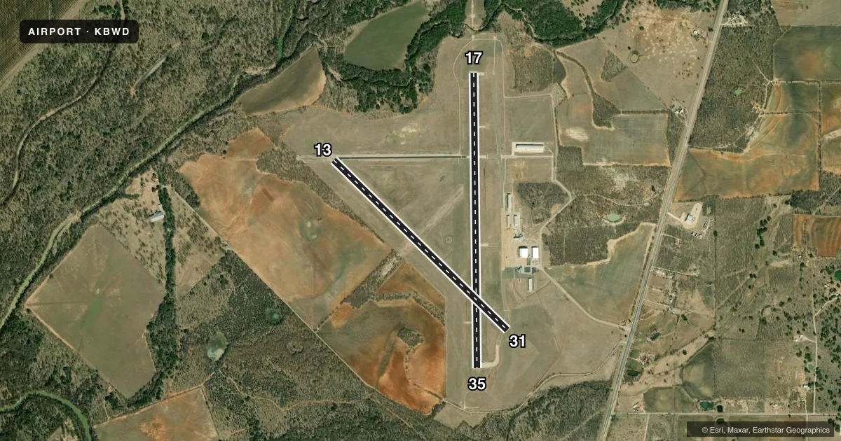
Runways & pattern
Full pagePattern entry · RWY 17
LEFT TRAFFIC| Runway | Heading (°M) | Length | Surface | Traffic |
|---|---|---|---|---|
| 17/35Favored | 175° / 355° | 5,599 ft | ASPH | Standard L |
| 13/31 | 130° / 310° | 4,608 ft | ASPH | Standard L |
Runway end performance
| End | TORA | TODA | ASDA | LDA | VGSI | Approach lights | Obstruction |
|---|---|---|---|---|---|---|---|
| 17 | — | — | — | — | PAPI 4-box left(3°) | MALS | 33', trees, 1185' from thr, 290' R of cntrln, slope 29 |
| 35 | — | — | — | — | PAPI 4-box left(3°) | — | 27', trees, 1100' from thr, 0' R of cntrln, slope 33 |
| 31 | — | — | — | — | — | — | 52', trees, 1450' from thr, 250' R of cntrln, slope 24 |
Declared distances in feet. TORA = takeoff run available, TODA = takeoff distance, ASDA = accelerate-stop, LDA = landing distance.
Airport sketch
Runways drawn to scale from FAA survey coordinates, rendered over satellite imagery. Not for navigation.
Approaches & charts
ILS · 1
Services on the field
Fuel grades, oxygen, maintenance, ramp storage and lighting — as declared to the FAA by the airport operator.
Fuel & services
- Fuel
- 100LLA
- Airframe repair
- Major
- Power plant repair
- Major
- Other services
- AFRT,CARGO,INSTR
Ramp & ground
- Transient storage
- Tie-down
- Hangar
- Landing fee
- No fee published
- Customs
- Not available
- Lighting schedule
- SEE RMK
- Beacon schedule
- SS-SR
- Beacon
- White / Green (civil land)(WG)
- Wind indicator
- Lighted
- Segmented circle
- Yes
Fuel & FBOs
Cheapest 100LL and Jet A on the field and nearby. Always confirm with the FBO before taxi.
Airport notes
Surface conditions, obstructions, local procedures, lighting outages and other notes published with each FAA cycle.
General notes
- FOR CD IF UNA TO CTC ON FSS FREQ, CTC FORT WORTH ARTCC AT 817-858-7584.
Lighting notes
- ACTVT MALS RWY 17; MIRL RWY 13/31 & 17/35 - CTAF.
Fuel notes
- 100LLFUEL 24 HRS SELF SVC. FOR FUEL SVC WHEN UNATNDD CALL 325-643-1482.
Other notes
- REPAIRS 325-643-1482
VFR map & nearby airports
VFR sectional. Tap any ICAO chip to open that airport.
Key facts · KBWD
Answer card- ICAO
- KBWD
- Name
- BROWNWOOD RGNL
- Location
- BROWNWOOD, TEXAS
- Elevation
- 1,386.7 ft MSL
- Traffic pattern altitude
- 2,386.7 ft MSL (1,000 AGL)
- Control tower
- Non-towered (use CTAF)
- Total runways
- 2
- Longest runway
- 17/35 · 5,599 ft
- Published ILS approaches
- 1
- Published frequencies
- 2
- Magnetic variation
- 4°
- Current flight rules
- VFR
- Current wind
- 190° at 7 kt
- Favored runway now
- RWY 17
Brownwood Rgnl sits in Brownwood, Texas. Field elevation is 1,386.7 ft MSL. The airport has two asphalt runways. The longest is 5,599 ft on 17/35. This is an uncontrolled field with CTAF and UNICOM both on 122.8. The ILS is published for runway 17.
Pattern altitude is not published. Use the standard 1,000 ft AGL for light piston traffic unless the current Chart Supplement says otherwise. The field is in central Texas, so expect warm weather performance changes in the summer. Watch your takeoff and landing numbers. The published remarks also note 24-hour self-serve 100LL. If no one is around for fuel service, call the airport at (325) 643-1482. Repairs are also available through that number.
Brownwood Regional Airport is the on-field FBO. It carries 100LL and Jet A. For a first look, runway 17 has a published lighting note. The approach lighting system on 17 is reported as malfunctioning. Medium intensity runway lights are available on both runways and are controlled by CTAF. If you need clearance delivery and cannot raise Flight Service, the remarks direct you to Fort Worth Center. Check the current Chart Supplement before departure for any changes to procedures or lighting status.