METAR & TAF T37
T37 does not publish a METAR.
Showing the nearest reporting station: KMNZ (HAMILTON MUNI) · 27.5 NM away. Conditions at T37 may differ.
METAR · KMNZ
Observed 16:15Z
KMNZ 271615Z AUTO 18010KT 8SM CLR 32/22 A3000 RMK AO2
- Wind
- 180° @ 10 kt
- Visibility
- 8 SM
- Temp / Dew
- 32°C / 22°C
- Altimeter
- 30.00 inHg
- Clouds
- CLR
- Density alt
- 3,748 ft
- Ceiling
- Unlimited
- Rules
- VFR
Airport info & contacts
Manager on record, flight service, ARTCC, attendance schedule and pattern altitude — published by the FAA and refreshed every 28 days.
Location
- From city
- 2 NM SW
- VFR sectional
- SAN ANTONIO
- ARTCC
- ZFW · FORT WORTH
- NOTAM facility
- FTW (NOTAM-D)
Airport manager
- Name
- ROBERT LINDSEY
- Phone
- 325-648-3186
- Address
- PO BOX 450, GOLDTHWAITE TX 76844-0450
Flight service · Hours
- FSS FTW
- FORT WORTH1-800-WX-BRIEF
- Attendance
- 0800-1700
Frequencies
Tap any row to copy the frequency to your clipboard.
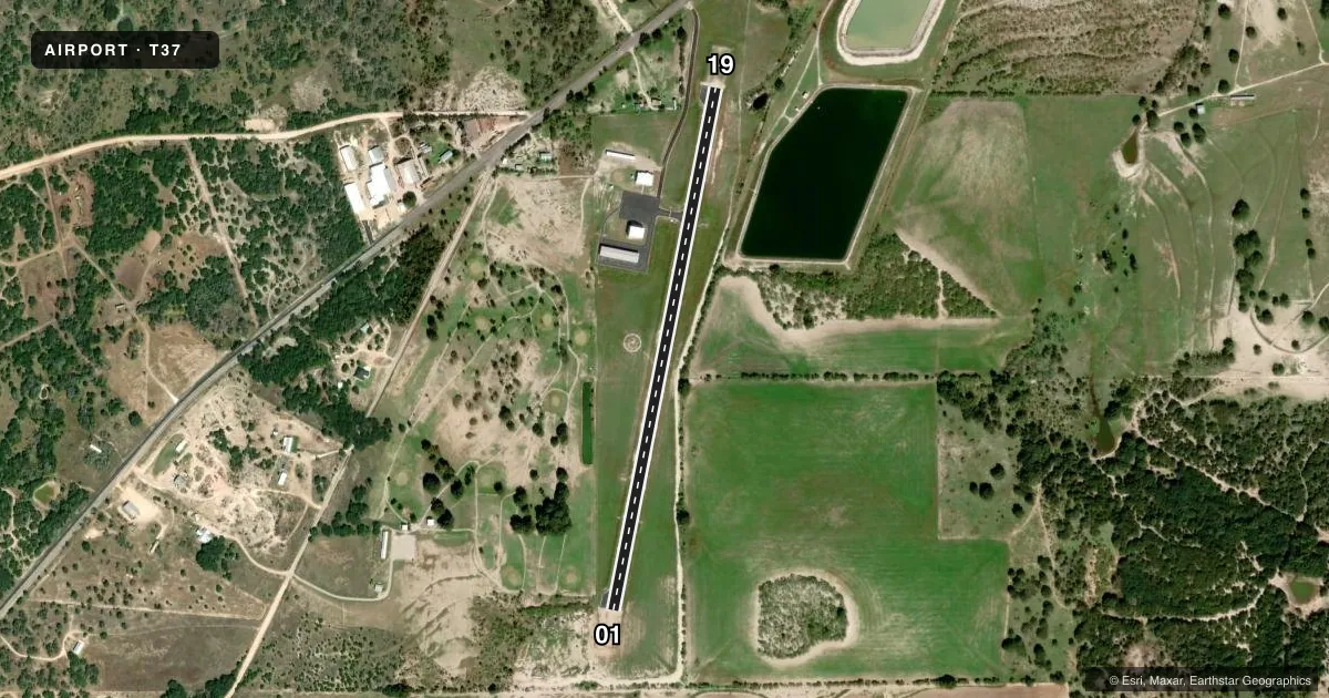
Runways & pattern
Full pagePattern entry · RWY 19
LEFT TRAFFICRunway end performance
| End | TORA | TODA | ASDA | LDA | VGSI | Approach lights | Obstruction |
|---|---|---|---|---|---|---|---|
| 01 | — | — | — | — | PAPI 2-box left(3°) | — | 26', trees, 510' from thr, 75' R of cntrln, slope 11 |
| 19 | — | — | — | — | PAPI 2-box left(3°) | — | 45', tree, 1140' from thr, 35' R of cntrln, slope 20 |
Declared distances in feet. TORA = takeoff run available, TODA = takeoff distance, ASDA = accelerate-stop, LDA = landing distance.
Airport sketch
Runways drawn to scale from FAA survey coordinates, rendered over satellite imagery. Not for navigation.
Approaches & charts
Services on the field
Fuel grades, oxygen, maintenance, ramp storage and lighting — as declared to the FAA by the airport operator.
Fuel & services
- Fuel
- Not available
Ramp & ground
- Transient storage
- Hangar
- Lighting schedule
- SEE RMK
- Beacon schedule
- SS-SR
- Beacon
- White / Green (civil land)(WG)
- Wind indicator
- Lighted
- Segmented circle
- Yes
Fuel & FBOs
Cheapest 100LL and Jet A on the field and nearby. Always confirm with the FBO before taxi.
Airport notes
Surface conditions, obstructions, local procedures, lighting outages and other notes published with each FAA cycle.
General notes
- DEER ON & INVOF ARPT.
- FOR CD CTC FORT WORTH ARTCC AT 817-858-7584.
Lighting notes
- MIRLS RWY 01/19 PRE-SET LOW INTST; TO INCR INTST AND ACTVT - CTAF.
Other notes
- PRVDD VFR OPNS.
- MANAGERCITY / ARPT MGR.
VFR map & nearby airports
VFR sectional. Tap any ICAO chip to open that airport.
Key facts · T37
Answer card- ICAO
- T37
- Name
- GOLDTHWAITE MUNI
- Location
- GOLDTHWAITE, TEXAS
- Elevation
- 1,457.6 ft MSL
- Traffic pattern altitude
- 2,457.6 ft MSL (1,000 AGL)
- Control tower
- Non-towered (use CTAF)
- Total runways
- 1
- Longest runway
- 01/19 · 3,200 ft
- Published ILS approaches
- 0
- Published frequencies
- 1
- Magnetic variation
- 4°
- Current flight rules
- VFR
- Current wind
- 180° at 10 kt
- Favored runway now
- RWY 19
Goldthwaite Muni is in Goldthwaite, Texas. The field elevation is 1,457.6 ft MSL. It has one runway, 01/19, at 3,200 ft asphalt. There is no control tower. CTAF is 122.9.
No ILS approaches are published here. The pattern altitude is not published in the facts, so use the standard 1,000 ft AGL pattern unless the current Chart Supplement says otherwise. Light piston pilots should plan for a simple VFR stop. The airport remarks note that the runway lights on 01 and 19 are preset to low intensity. Use the CTAF to increase intensity and activate them. Deer are reported on and near the airport. Keep a sharp scan on taxi, takeoff and landing. For clearance delivery, contact Fort Worth ARTCC at 817-858-7584. There are no on-field FBOs listed in the facts, so verify fuel and services with the airport operator before arrival.