METAR & TAF KGDJ
Current METAR
Observed 22:15Z
KGDJ 132215Z AUTO 18013G17KT 10SM FEW050 34/21 A2987 RMK AO2
- Wind
- 180° @ 13G17 kt
- Visibility
- 10 SM
- Temp / Dew
- 34°C / 21°C
- Altimeter
- 29.87 inHg
- Clouds
- FEW
- Density alt
- 3,378 ft
- Ceiling
- Unlimited
- Rules
- VFR
Airport info & contacts
Manager on record, flight service, ARTCC, attendance schedule and pattern altitude — published by the FAA and refreshed every 28 days.
Location
- From city
- 2 NM W
- VFR sectional
- DALLAS-FT WORTH
- ARTCC
- ZFW · FORT WORTH
- NOTAM facility
- GDJ (NOTAM-D)
Airport manager
- Name
- CODY J. MATHIS, C.M.
- Phone
- 817-579-8533
- Address
- 840 ARCHER CT, GRANBURY TX 76048
Flight service · Hours
- FSS FTW
- FORT WORTH1-800-WX-BRIEF
- Attendance
- 0700-1900
Frequencies
Tap any row to copy the frequency to your clipboard.
Runways & pattern
Full pagePattern entry · RWY 19
RIGHT TRAFFICRunway end performance
| End | TORA | TODA | ASDA | LDA | VGSI | Approach lights | Obstruction |
|---|---|---|---|---|---|---|---|
| 01 | — | — | — | — | PAPI 2-box left(3°) | — | 40', pole, 1500' from thr, 85' R of cntrln, slope 32 |
| 19 | — | — | — | — | PAPI 2-box left(3°) | — | — |
Declared distances in feet. TORA = takeoff run available, TODA = takeoff distance, ASDA = accelerate-stop, LDA = landing distance.
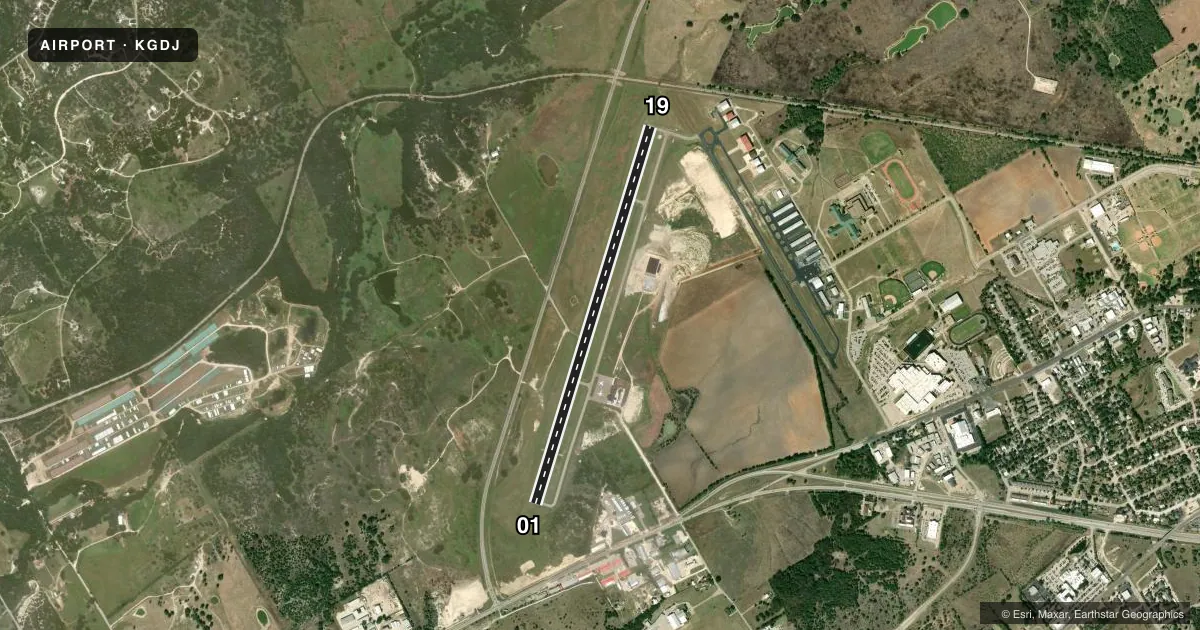
Airport sketch
Runways drawn to scale from FAA survey coordinates, rendered over satellite imagery. Not for navigation.
Approaches & charts
Services on the field
Fuel grades, oxygen, maintenance, ramp storage and lighting — as declared to the FAA by the airport operator.
Fuel & services
- Fuel
- 100LLA+
- Oxygen (bottled)
- Not available
- Oxygen (bulk)
- Not available
- Airframe repair
- Major
- Power plant repair
- Major
- Other services
- AVNCS,INSTR,RNTL
Ramp & ground
- Transient storage
- Tie-down
- Hangar
- Landing fee
- No fee published
- Lighting schedule
- SEE RMK
- Beacon schedule
- SS-SR
- Beacon
- White / Green (civil land)(WG)
- Wind indicator
- Lighted
- Segmented circle
- Yes
Fuel & FBOs
Cheapest 100LL and Jet A on the field and nearby. Always confirm with the FBO before taxi.
Airport notes
Surface conditions, obstructions, local procedures, lighting outages and other notes published with each FAA cycle.
General notes
- FOR CD CTC FORT WORTH ARTCC AT 817-858-7584.
- WILDLIFE ON AND INVOF ARPT.
Lighting notes
- MIRL RWY 01/19 PRESET LOW INTST; TO INCR INTST ACTVT - CTAF.
Fuel notes
- 100LLFUEL 24 HR SELF SERVE.
- A+FOR JET A+ AFT HRS CALL 817-529-4913.
VFR map & nearby airports
VFR sectional. Tap any ICAO chip to open that airport.
Key facts · KGDJ
Answer card- ICAO
- KGDJ
- Name
- GRANBURY RGNL
- Location
- GRANBURY, TEXAS
- Elevation
- 835.2 ft MSL
- Traffic pattern altitude
- 1,835.2 ft MSL (1,000 AGL)
- Control tower
- Non-towered (use CTAF)
- Total runways
- 1
- Longest runway
- 01/19 · 5,201 ft
- Published ILS approaches
- 0
- Published frequencies
- 2
- Magnetic variation
- 3°
- Current flight rules
- VFR
- Current wind
- 180° at 13 kt
- Favored runway now
- RWY 19
Granbury Rgnl sits in Granbury, Texas. The field elevation is 835.2 ft MSL. It has one runway, 01/19, at 5,201 ft. There is no control tower. CTAF and UNICOM are both 123.0. No ILS approaches are published here.
Pattern altitude is not published. Use the standard 1,000 ft AGL for light piston traffic unless the current FAA Chart Supplement says otherwise. The runway lights on 01/19 are medium intensity lights set to low by default. Use the CTAF to step them up when needed. Wildlife is reported on and near the airport. That matters for taxi, takeoff and landing rolls.
Granbury Regional Airport is on the field. It carries AVGAS 100LL, Jet A and Jet A Prist. 100LL is available 24 hours self-serve. For Jet A plus after hours, call the number in the Chart Supplement or the FBO directly. For clearance delivery, contact Fort Worth ARTCC at the published number before departure if you need it. First-time arrivals should plan for non-towered traffic, watch for wildlife and verify any current airport notes before flying in.