METAR & TAF KRPH
Current METAR
Observed 13:15Z
KRPH 271315Z AUTO 00000KT 10SM CLR 27/21 A2995 RMK AO2 T02650208 $
- Wind
- 000° @ 0 kt
- Visibility
- 10 SM
- Temp / Dew
- 27°C / 21°C
- Altimeter
- 29.95 inHg
- Clouds
- CLR
- Density alt
- 2,795 ft
- Ceiling
- Unlimited
- Rules
- VFR
Airport info & contacts
Manager on record, flight service, ARTCC, attendance schedule and pattern altitude — published by the FAA and refreshed every 28 days.
Location
- From city
- 2 NM E
- VFR sectional
- DALLAS-FT WORTH
- ARTCC
- ZFW · FORT WORTH
- NOTAM facility
- RPH (NOTAM-D)
Airport manager
- Name
- SCOTT BELL
- Phone
- 940-456-5901
- Address
- 1810 4TH STREET, GRAHAM TX 76450
Flight service · Hours
- FSS FTW
- FORT WORTH1-800-WX-BRIEF
- Attendance
- MON-FRI · 0800-1700
Frequencies
Tap any row to copy the frequency to your clipboard.
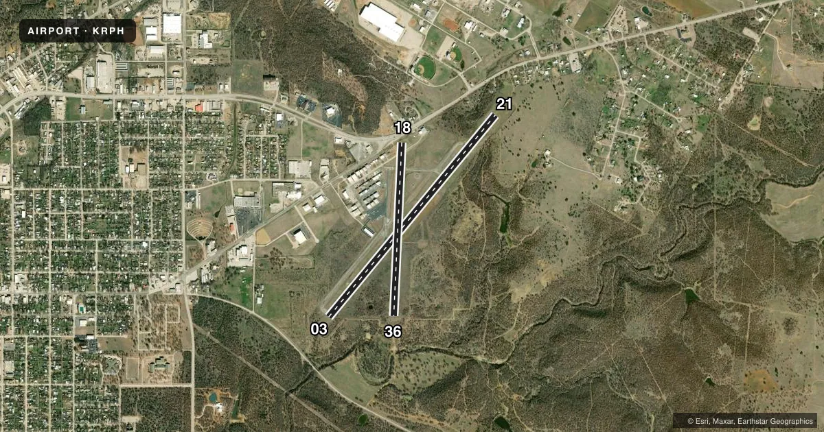
Runways & pattern
Full pagePattern entry · RWY 03
LEFT TRAFFIC| Runway | Heading (°M) | Length | Surface | Traffic |
|---|---|---|---|---|
| 03/21 | 33° / 213° | 5,001 ft | ASPH | Standard L |
| 18/36 | 176° / 356° | 3,317 ft | ASPH | Standard L |
Runway end performance
| End | TORA | TODA | ASDA | LDA | VGSI | Approach lights | Obstruction |
|---|---|---|---|---|---|---|---|
| 03 | — | — | — | — | PAPI 2-box left(3°) | — | 42', pline, 1636' from thr, 500' R of cntrln, slope 34 |
| 21 | — | — | — | — | PAPI 2-box right(3°) | — | 25', trees, 260' from thr, 192' R of cntrln, slope 2 |
| 18 | — | — | — | — | — | — | 15', road, 200' from thr, 0' R of cntrln, slope 0 |
Declared distances in feet. TORA = takeoff run available, TODA = takeoff distance, ASDA = accelerate-stop, LDA = landing distance.
Airport sketch
Runways drawn to scale from FAA survey coordinates, rendered over satellite imagery. Not for navigation.
Approaches & charts
Services on the field
Fuel grades, oxygen, maintenance, ramp storage and lighting — as declared to the FAA by the airport operator.
Fuel & services
- Fuel
- 100LLA+
- Oxygen (bottled)
- Not available
- Oxygen (bulk)
- Not available
- Airframe repair
- Major
- Power plant repair
- Major
Ramp & ground
- Transient storage
- Tie-down
- Hangar
- Landing fee
- No fee published
- Customs
- Not available
- Lighting schedule
- SEE RMK
- Beacon schedule
- SS-SR
- Beacon
- White / Green (civil land)(WG)
- Wind indicator
- Lighted
- Segmented circle
- Yes
Fuel & FBOs
Cheapest 100LL and Jet A on the field and nearby. Always confirm with the FBO before taxi.
Airport notes
Surface conditions, obstructions, local procedures, lighting outages and other notes published with each FAA cycle.
General notes
- WILDLIFE ON & INVOF ARPT.
- FOR CD CTC FORT WORTH ARTCC AT 817-858-7584.
Lighting notes
- MIRL RWY 03/21 SS-SR PRESET TO LOW, TO INCR INTST ACTVT - CTAF.
Approach & departure obstructions
- 1819 FT RD, 62 FT DSTC, 7 FT FENCE 0 FT DSTC.
- 2132 FT TREE, 190 FT DSTC, 230 FT R.
- 18OBSTN CNTRLN SLOPE 37:1 TO DTHR.
Other notes
- MANAGERSBELL@GRAHAMTEXAS.NET
VFR map & nearby airports
VFR sectional. Tap any ICAO chip to open that airport.
Key facts · KRPH
Answer card- ICAO
- KRPH
- Name
- GRAHAM MUNI
- Location
- GRAHAM, TEXAS
- Elevation
- 1,122.8 ft MSL
- Traffic pattern altitude
- 2,122.8 ft MSL (1,000 AGL)
- Control tower
- Non-towered (use CTAF)
- Total runways
- 2
- Longest runway
- 03/21 · 5,001 ft
- Published ILS approaches
- 0
- Published frequencies
- 2
- Magnetic variation
- 7°
- Current flight rules
- VFR
- Current wind
- 000° at 0 kt
- Favored runway now
- –
Graham Muni is in Graham, Texas. The field elevation is 1,122.8 ft MSL. It has two asphalt runways. The longest is 5,001 ft on runway 03/21. The shorter runway is 18/36 at 3,317 ft. There is no control tower. CTAF and UNICOM are both 122.975.
No ILS approaches are published here. Pattern altitude is not published, so plan on the standard 1,000 ft AGL for light piston traffic unless the current FAA Chart Supplement says otherwise. The on-field FBO is Graham Municipal Airport. It carries 100LL and Jet A Prist. Call the FBO directly at (940) 549-6150 for current service details.
The published remarks matter here. There are several obstructions near the runways, including trees near 03 and 21, a pole line near 03, a road and fence near 18. Wildlife is also reported on and near the airport. Runway 03/21 lighting is preset to low from sunset to sunrise. Use the CTAF to increase intensity if needed. For hangar availability, call ahead at 940-456-4320. This is a non-towered field with a relatively high elevation for North Texas. Check density altitude and runway performance before you go. If you need clearance delivery, Fort Worth ARTCC is listed in the remarks.