METAR & TAF KCOT
Current METAR
Observed 12:53Z
KCOT 271253Z AUTO 13008KT 9SM CLR 26/22 A2995 RMK AO2 SLP132 T02560222
- Wind
- 130° @ 8 kt
- Visibility
- 9 SM
- Temp / Dew
- 26°C / 22°C
- Altimeter
- 29.95 inHg
- Clouds
- CLR
- Density alt
- 1,871 ft
- Ceiling
- Unlimited
- Rules
- VFR
Airport info & contacts
Manager on record, flight service, ARTCC, attendance schedule and pattern altitude — published by the FAA and refreshed every 28 days.
Location
- From city
- 1 NM NE
- VFR sectional
- SAN ANTONIO
- ARTCC
- ZHU · HOUSTON
- NOTAM facility
- COT (NOTAM-D)
Airport manager
- Name
- E T PAGE III
- Phone
- 830-879-3858
- Address
- 550 AIRPORT ROAD, COTULLA TX 78014
Flight service · Hours
- FSS SJT
- SAN ANGELO1-800-WX-BRIEF
- Attendance
- 0800-1800
Frequencies
Tap any row to copy the frequency to your clipboard.
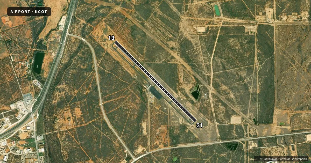
Runways & pattern
Full pagePattern entry · RWY 13
LEFT TRAFFICRunway end performance
| End | TORA | TODA | ASDA | LDA | VGSI | Approach lights | Obstruction |
|---|---|---|---|---|---|---|---|
| 13 | — | — | — | — | PAPI 4-box left(3°) | — | — |
| 31 | — | — | — | — | PAPI 4-box left(3°) | — | 12', gnd, 500' from thr, 250' R of cntrln, slope 25 |
Declared distances in feet. TORA = takeoff run available, TODA = takeoff distance, ASDA = accelerate-stop, LDA = landing distance.
Airport sketch
Runways drawn to scale from FAA survey coordinates, rendered over satellite imagery. Not for navigation.
Approaches & charts
Services on the field
Fuel grades, oxygen, maintenance, ramp storage and lighting — as declared to the FAA by the airport operator.
Fuel & services
- Fuel
- 100LLA+
- Oxygen (bottled)
- High pressure
- Oxygen (bulk)
- Not available
- Airframe repair
- Minor
- Power plant repair
- Minor
Ramp & ground
- Transient storage
- Tie-down
- Hangar
- Landing fee
- No fee published
- Customs
- Not available
- Lighting schedule
- SEE RMK
- Beacon schedule
- SS-SR
- Beacon
- White / Green (civil land)(WG)
- Wind indicator
- Lighted
- Segmented circle
- Yes
Fuel & FBOs
Cheapest 100LL and Jet A on the field and nearby. Always confirm with the FBO before taxi.
Airport notes
Surface conditions, obstructions, local procedures, lighting outages and other notes published with each FAA cycle.
General notes
- AMGR LIVES ON ARPT.
- RENTAL CARS AVBL.
- FOR CD IF UNA TO CTC ON FSS FREQ, CTC HOUSTON ARTCC AT 281-230-5622.
Lighting notes
- DUSK-DAWN. MIRL RWY 13/31 PRESET LOW INTST; TO INCR INTST ACTVT - CTAF.
Fuel notes
- 100LLFUEL & SVC AVBL ON CALL AFT HRS 830-879-3858.
Other notes
- RAMP FEE WAIVED WITH MINIMUM FUEL PURCHASE.
- 1ARPT UNATNDD CHRISTMAS.
VFR map & nearby airports
VFR sectional. Tap any ICAO chip to open that airport.
Key facts · KCOT
Answer card- ICAO
- KCOT
- Name
- COTULLA-LA SALLE COUNTY
- Location
- COTULLA, TEXAS
- Elevation
- 474.3 ft MSL
- Traffic pattern altitude
- 1,474.3 ft MSL (1,000 AGL)
- Control tower
- Non-towered (use CTAF)
- Total runways
- 1
- Longest runway
- 13/31 · 6,005 ft
- Published ILS approaches
- 0
- Published frequencies
- 2
- Magnetic variation
- 6°
- Current flight rules
- VFR
- Current wind
- 130° at 8 kt
- Favored runway now
- RWY 13
Cotulla-La Salle County Airport sits in Cotulla, Texas. Field elevation is 474.3 ft MSL. The airport has one runway. Runway 13/31 is 6,005 ft long with asphalt pavement. There is no control tower. CTAF and UNICOM are both 122.7. No ILS approaches are published here.
Pattern altitude is not published. Use the standard 1,000 ft AGL for light piston traffic unless the current Chart Supplement says otherwise. That puts the pattern at about 1,474.3 ft MSL. Page Aviation is on the field. It carries 100LL and Jet A. Ramp fee is waived with a minimum fuel purchase. Fuel and service are available after hours by calling the FBO. Runway lights on 13/31 are preset to low intensity from dusk to dawn. Use the CTAF to increase intensity.
This is an unattended field on Christmas. The airport manager lives on the airport. If you need clearance delivery and cannot reach Flight Service, Houston ARTCC is listed as a backup contact. Check the current Chart Supplement before departure for any changes to lighting, services, or local procedures.