METAR & TAF 23R
23R does not publish a METAR.
Showing the nearest reporting station: KCVB (CASTROVILLE MUNI) · 13.1 NM away. Conditions at 23R may differ.
METAR · KCVB
Observed 13:15Z
KCVB 271315Z AUTO 10004KT 10SM BKN014 25/23 A2998 RMK AO2
- Wind
- 100° @ 4 kt
- Visibility
- 10 SM
- Temp / Dew
- 25°C / 23°C
- Altimeter
- 29.98 inHg
- Clouds
- BKN
- Density alt
- 1,996 ft
- Ceiling
- 1,400 ft AGL
- Rules
- MVFR
Airport info & contacts
Manager on record, flight service, ARTCC, attendance schedule and pattern altitude — published by the FAA and refreshed every 28 days.
Location
- From city
- 2 NM W
- VFR sectional
- SAN ANTONIO
- ARTCC
- ZHU · HOUSTON
- NOTAM facility
- SJT (NOTAM-D)
Airport manager
- Name
- DONALD L JORDAN
- Phone
- 830-663-2804
- Address
- 303 S TEEL DR, DEVINE TX 78016
Flight service · Hours
- FSS SJT
- SAN ANGELO1-800-WX-BRIEF
- Attendance
- MON-FRI · DAWN-DUSK
Frequencies
Tap any row to copy the frequency to your clipboard.
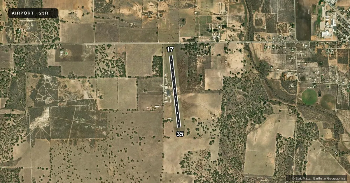
Runways & pattern
Full pagePattern entry · RWY 17
LEFT TRAFFICRunway end performance
| End | TORA | TODA | ASDA | LDA | VGSI | Approach lights | Obstruction |
|---|---|---|---|---|---|---|---|
| 17 | — | — | — | — | PAPI 2-box left(3°) | — | 15', road, 570' from thr, 0' R of cntrln, slope 24 |
| 35 | — | — | — | — | PAPI 2-box left(3°) | — | 70', trees, 1675' from thr, 0' R of cntrln, slope 21 |
Declared distances in feet. TORA = takeoff run available, TODA = takeoff distance, ASDA = accelerate-stop, LDA = landing distance.
Airport sketch
Runways drawn to scale from FAA survey coordinates, rendered over satellite imagery. Not for navigation.
Approaches & charts
Services on the field
Fuel grades, oxygen, maintenance, ramp storage and lighting — as declared to the FAA by the airport operator.
Fuel & services
- Fuel
- 100LL
- Oxygen (bottled)
- Not available
- Oxygen (bulk)
- Not available
- Airframe repair
- Major
- Power plant repair
- Major
- Other services
- INSTR
Ramp & ground
- Transient storage
- Tie-down
- Landing fee
- No fee published
- Customs
- Not available
- Lighting schedule
- SEE RMK
- Beacon schedule
- SS-SR
- Beacon
- White / Green (civil land)(WG)
- Wind indicator
- Lighted
- Segmented circle
- Yes
Fuel & FBOs
Cheapest 100LL and Jet A on the field and nearby. Always confirm with the FBO before taxi.
Airport notes
Surface conditions, obstructions, local procedures, lighting outages and other notes published with each FAA cycle.
General notes
- DEER ON & INVOF ARPT.
- FOR CD CTC HOUSTON ARTCC AT 281-230-5622.
Lighting notes
- MIRL RWY 17/35 PRESET LOW INTST; TO INCR INTST ACTVT - CTAF.
Other notes
- MANAGERCITY/AIRPORT MANAGER.
VFR map & nearby airports
VFR sectional. Tap any ICAO chip to open that airport.
Key facts · 23R
Answer card- ICAO
- 23R
- Name
- DEVINE MUNI
- Location
- DEVINE, TEXAS
- Elevation
- 702.2 ft MSL
- Traffic pattern altitude
- 1,702.2 ft MSL (1,000 AGL)
- Control tower
- Non-towered (use CTAF)
- Total runways
- 1
- Longest runway
- 17/35 · 3,399 ft
- Published ILS approaches
- 0
- Published frequencies
- 1
- Magnetic variation
- 7°
- Current flight rules
- MVFR
- Current wind
- 100° at 4 kt
- Favored runway now
- RWY 17
Devine Muni is in Devine, Texas. The field elevation is 702.2 ft MSL. It has one runway, 17/35, which is 3,399 ft long. There is no control tower. CTAF is 122.9.
No ILS approaches are published here. The runway lights on 17/35 are medium intensity lights preset to low. Use the CTAF to increase intensity. Deer are reported on and near the airport, so a careful scan on taxi, takeoff and landing makes sense. For clearance delivery, Houston ARTCC handles it by phone at 281-230-5622.
Pattern altitude is not published. Use the standard 1,000 ft AGL pattern unless the current Chart Supplement says otherwise. That puts the pattern at about 1,702 ft MSL based on the listed field elevation. Check the current Chart Supplement before flight for any updates to procedures or remarks. With one asphalt runway and no tower, expect to self-announce. Manage spacing closely if traffic is using both directions on 17/35.