METAR & TAF KSKF
Current METAR
Observed 14:15Z
KSKF 271415Z AUTO 16006KT 8SM OVC013 27/23 A2996 RMK AO2 CIG 011 RWY34 SLP136 $
- Wind
- 160° @ 6 kt
- Visibility
- 8 SM
- Temp / Dew
- 27°C / 23°C
- Altimeter
- 29.96 inHg
- Clouds
- OVC
- Density alt
- 2,247 ft
- Ceiling
- 1,300 ft AGL
- Rules
- MVFR
Airport info & contacts
Manager on record, flight service, ARTCC, attendance schedule and pattern altitude — published by the FAA and refreshed every 28 days.
Location
- From city
- 4 NM SW
- VFR sectional
- SAN ANTONIO
- ARTCC
- ZHU · HOUSTON
- NOTAM facility
- SKF (NOTAM-D)
Airport manager
- Name
- DESIREE CURTIS
- Phone
- 210-925-5879
- Address
- 907 BILLY MITCHELL BLVD, SAN ANTONIO TX 78226-9805
Flight service · Hours
- FSS SJT
- SAN ANGELO1-800-WX-BRIEF
- Attendance
- ALL
Frequencies
Tap any row to copy the frequency to your clipboard.
Runways & pattern
Full pagePattern entry · RWY 16
LEFT TRAFFICRunway end performance
| End | TORA | TODA | ASDA | LDA | VGSI | Approach lights | Obstruction |
|---|---|---|---|---|---|---|---|
| 16 | — | — | — | — | PAPI 4-box left(3°) | ALSF1 | — |
| 34 | — | — | — | — | PAPI 4-box right(3°) | ALSF1 | — |
Declared distances in feet. TORA = takeoff run available, TODA = takeoff distance, ASDA = accelerate-stop, LDA = landing distance.
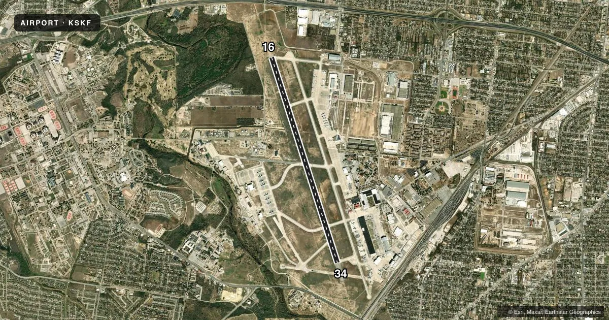
Airport sketch
Runways drawn to scale from FAA survey coordinates, rendered over satellite imagery. Not for navigation.
Approaches & charts
ILS · 2
Services on the field
Fuel grades, oxygen, maintenance, ramp storage and lighting — as declared to the FAA by the airport operator.
Fuel & services
- Fuel
- 100LLA+
- Oxygen (bottled)
- Not available
- Oxygen (bulk)
- HIGH/LOW
- Airframe repair
- Major
- Power plant repair
- Major
- Other services
- CARGO
Ramp & ground
- Transient storage
- Tie-down
- Customs
- Not available
- Lighting schedule
- SS-SR
- Beacon schedule
- SS-SR
- Beacon
- White / Green (civil land)(WG)
- Wind indicator
- Yes
- Segmented circle
- No
Fuel & FBOs
Cheapest 100LL and Jet A on the field and nearby. Always confirm with the FBO before taxi.
Airport notes
Surface conditions, obstructions, local procedures, lighting outages and other notes published with each FAA cycle.
General notes
- CAUTION: PROBABILITY OF HYDROPLANING AT ALL SPEEDS ENTIRE RWY.
- ANG: OPR 1345-2230Z++ TUE-SAT. PPR FOR USE OF ANG RAMP, DSN 945-5934, C210-925-5934.
- AFRC: PPR FOR USE OF AFRC RAMP, DSN 945-4330, C210-925-4330.
- ACFT WITH WING SPAN LARGER THAN 93 FT NOT AUTHORIZED IN ARM/DEARM PADS.
- CSTMS/AG/IMG: CSTMS, PLANT QUARANTINE AND IMG AVBL, CTC AMOPS BY FONE PATCH OR PTD RDO 2 HR BEFORE ARR. ALL PERS, EXCLD ACTIVE US MIL, MUST CLEAR IMG INBD.
- BEARING STRENGTH RWY 16/34 - ST175 SBTT590 DDT870 TRT580.
- MISC: ACFT WITH CODE 6 AND ABV CTC AMOPS FONE PATCH/PTD WITH BLOCK TIME AT LEAST 1 HR BEFORE LDG.
- A-GEAR: BAK-12A(B) CABLES RAISED BY BAK-14 DEVICE O/R TO CTL TWR. POTENTIAL FOR HOOK SKIP AT BAK-12 CABLE SYS DUE TO IRREG EDGES AND UNEVEN DEPTHS WI 200 FT OF ARRESTING SYS
- MISC: OFFICIAL POINT OF OBSERVATION DOES NOT ALLOW A CLEAR UNOBSTRUCTED VIEW OF RWY. WX TECHNICIAN VIEW FROM N TO SE IS PARTIALLY OBSTRUCTED BY TREES, BLDGS, & HANGARS. TECHNICIAN RELIES ON COOPERATIVE WX WATCH WITH TWR. HIGH INTENSITY SECURITY LGTS HINDER ABILITY TO DETERMINE SKY COND AT NIGHT.
- RSTD: TRAN ACFT EXP DELAYS AND MAY BE LTD TO ONE APCH TO A FULL STOP FOR HOME STN FORMAL TRNG UNIT OPS AND TACTICAL ARR AND DEP TRNG MON-FRI 1500-0400Z ++.
- CIVILIAN RAMP LCTD NE OF RY. GA RAMP ACCESS VIA TWYS A1, B AND C.
- CUSTOMS/AG/IMG RQR 72 HRS PN CTC FBO. J8-ATLANTIC AVN, 1200-0600Z++, 2 HR PN FOR DEFUELING AND RESERVICE.
- RSTD: QUIET HRS 0500-1200++ DLY DEP AND FULL STOP LDG ONLY.
- MILITARY SERVICE: FUEL- A++, A+. MIL FUEL UNAVBL SAT 0400-1200Z++.
- WARNING: LARGE SUCCESSIVE FLOCKS OF CATTLE EGRETS, 5 TO 50 IN NO., HAVE BEEN OBSERVED FLYING BLW 300 FT AGL ACROSS N END OF RWY EV MORNING AT SR FOR UP TO 2 HRS, RETURNING WITHIN 2 HR OF SS. BASH PH II IN EFF 1 MAR-30 NOV. CAUTION: NORTH END UNDERRUN/OVRN 147' PAVED, 853' UNPAVED. RUNWAY AND MAJORITY OF TAXIWAY PAVEMENT SHOULDERS EXCEED STANDARD DIMENSIONS AND ARE NOT MARKED WITH YELLOW CHEVRON DECEPTIVE SURFACE MARKINGS TO INDICATE UNUSABLE.
- USER FEES APPLICABLE TO CIVIL ACFT.
- MILITARY SERVICE: TRAN ALERT - OPR 1130-0430Z++ MON-FRI, 1330-0230Z++ SAT-SUN, CLSD FEDERAL HOL; OT 2 HR PN RQR CTC AMOPS. 1 HR PN FOR ALL ACFT SVC; CTC AMOPS DSN 945-6803,C210-925-6803 OR PTD TO AVOID DELAYS. UNA TO SUPPORT TRAN ACFT LCL SORTIES.
- MILITARY SERVICE: JASU -(A/M32A-86D, A/M32A-95 LASS).
- MILITARY SERVICE: FLUID - SP PRESAIR LHOX LOX LHNIT.
- MILITARY SERVICE: OIL - O-133-148-156; SOAP - AVBL 2000-0600Z++ MON; 1230-0600Z++ TUE-THUR; 1230 - 2230Z++ FRI.
- MILITARY-MISC: USAF TRAN ACFT WILL USE TRAN ALERT SVC AND PARK ON MIL RAMP. NON-USAF TRAN ACFT MAY PRK AT MIL RAMP OR ATLANTIC AVIATION FBO ON CIV RAMP; FOR QNS CTC AFLD MGMT OPNS C210-925-6803.
- CONTACT PORT SAN ANTONIO OPS 210-362-7837/7838.
- SERVICE-LGT: RWY 34 PAPI LCTD NSTD ON RGT (EAST) SIDE OF RWY 34.
- ACFT ARR BTN 0500-1200Z++ EXP FULL STOP LDG. NO AFTER BURNER TKOF DUR THESE TIMES WO PRIOR COORD AND APVL.
- PORT OPERATIONS 210-362-7875.
- CAUTION: HVY RUBBER DEPOSITS OBSCURING RWY MRKGS AT TDZS
- TWY G WEST OF TWY H IS FOR 149FW USE.
- RSTD:REQ FOR PPR WILL BE TAKEN NO EARLIER THAN 7 DAYS PRIOR TO PLANNED MISSION. AT LEAST 24 HR PN RQRD FOR PPR, EXC MEDEVAC, DV AND OTHER ACFT ON A CASE BY CASE BASIS APVD BY DO. CTC BASE OPS DSN 945-6803, C210-925-6803. PPR GOOD FOR +1/-1 HR PPR BLOCK TIME. COORD OF PPR OUTSIDE OF BLOCK TIME BY FONE IS RQRD.
- MISC: RWY COND CODE (RWYCC) NOT RPRTD.
- MISC: LTD CLASSIFIED MTRLS STORAGE: EXCESS AND TS MTRLS MUST GO TO 433 AW/CP.
- APN PSA RAMP CLSD IN BOTH DRCTNS AT TWY B AT APN ENTRANCE TO TWY C TO ALL ACFT UNLESS UNDER TOW.
- MISC: TACAN CK POINT/ALTM SIGN ON TWY F AND B SITED OPPOSITE DRCTN OF TACAN.
- SERVICE-LGT: TWY F: NO TWY END LGTS.
- CAUTION: INST HOLD LINE MRK FADED ON TWY F.
- RWY: ALL RWY GROOVED.
- AIRPORT REMARKS: AERODROME CLSD DLY FM 2300L-0700L. ONLY PRE-APVD ACFT WITH 24-48 HRS NOTICE ARE PMTD TO ARR/DEP DURG CLOSURE HRS. CTC ARPT MGMT FOR PRE-APVL CDN AT COMM/DSN 210-925-6803/945-6803.
- CAUTION: FIRST 960 FT X 150 FT RWY 16, FIRST 1022 FT X 150 FT RWY 34 GROOVED CONC. RWY 16/34 MID ROLLOUT 9568 FT X 75 FT GROOVED CONC. MID ROLLOUT 37.5 FT INWARD FM RWY SIDE STRIPE/EDGE MRKGS UNGROOVED. FRICTION INADQT DUE TO RUBBER BUILDUP AT RWY TDZ. CONDS WORSEN WHEN RSCD WET.
Lighting notes
- OTS.
Fuel notes
- 100LLACFT USING AVGAS SELF-SERVE: DO NOT DEVIATE FM TAX LNS TO/FM AVGAS SELF-SERVE TO ENSURE SAFE DSTC FM OTR OPNS. 100LL FUEL IS SELF SERVE AT PORT SAN ANTONIO AND FULL SERVICE AT FBO.
Arresting gear
- 16_BAK-12BAK-14 BAK-12A(B) (1853').
- 34_BAK-12BAK-14 BAK-12A(B) (1677') HOOK MB100 (60' OVRN).
Other notes
- LANDING FEE FOR ALL ACFT EXCLUDING U.S. MIL AND ACFT LESS THAN 12,500LBS. INVOICED BY PSA AIRPORT DEPARTMENT, IAW JUA
- RECTANGULAR 1700 FT MSL, CONVL 2200 FT MSL, FTR TYPE/OVERHEAD 2700FT MSL. AETC ACFT EXP REDUCED RWY SEPARATION DAY/VFR. TRAN FTR ACFT MUST NOTIFY TWR ON INITIAL CTC OF REDUCED SEPARATION IS NOT DESIRED.
- CSTMS; PLANT QUARANTINE & IMG SVC AVBL CTC BASE OPNS 2 HRS PN. ALL PSNL MUST CLEAR IMG INBD.
- MANAGERFOR CIVILIAN OPERATIONS, CONTACT PORT OPERATIONS 210-362-7875.
VFR map & nearby airports
VFR sectional. Tap any ICAO chip to open that airport.
Key facts · KSKF
Answer card- ICAO
- KSKF
- Name
- KELLY FLD
- Location
- SAN ANTONIO, TEXAS
- Elevation
- 690.6 ft MSL
- Traffic pattern altitude
- 1,690.6 ft MSL (1,000 AGL)
- Control tower
- Towered · 24
- Total runways
- 1
- Longest runway
- 16/34 · 11,550 ft
- Published ILS approaches
- 2
- Published frequencies
- 16
- Magnetic variation
- 4°
- Current flight rules
- MVFR
- Current wind
- 160° at 6 kt
- Favored runway now
- RWY 16
KELLY FLD sits in San Antonio, Texas. Field elevation is 690.6 ft MSL. The airport has one runway, 16/34, at 11,550 ft of concrete. The tower is open 24 hours. Two ILS approaches are published, one for runway 16 and one for runway 34. Pattern altitude is not published. Use the standard 1,000 ft AGL pattern for light piston aircraft unless ATC gives you something different. That puts you at about 1,691 ft MSL.
Atlantic Aviation is on field. It carries 100LL and Jet A. Call (210) 921-6100 for current service details.
This is a joint-use field with military activity. Expect a more structured environment than a typical GA airport. The published remarks also note a daily closure from 2300 local to 0700 local. Only pre-approved aircraft with 24 to 48 hours notice may arrive or depart during that window. Customs, plant quarantine and immigration are available. Plan to coordinate 2 hours before arrival if you need those services. The field also has a landing fee for most aircraft, with exemptions listed in the Chart Supplement. One more thing to watch is the published cable hazard near the Baker-12A system. If you are new to the airport, brief the current Chart Supplement and call the airport operator or Atlantic Aviation before departure.